The
Great Kantō earthquake struck the
Kantō plain on the
Japanese main island of
Honshū at 11:58:44 am JST (2:58:44
UTC) on Saturday, September 1, 1923. Varied accounts indicate the duration of the earthquake was between four and 10 minutes.
This was the deadliest earthquake in Japanese history, and at the time
was the most powerful earthquake ever recorded in the region. The
2011 Tōhoku earthquake later surpassed that record, at magnitude 9.0.
This earthquake devastated
Tokyo, the port city of
Yokohama, and the surrounding prefectures of
Chiba,
Kanagawa, and
Shizuoka, and caused widespread damage throughout the Kantō region. The power was so great in
Kamakura, over 60 km (37 mi) from the epicenter, it moved the
Great Buddha statue, which weighs about 93 short tons (84,000 kg), almost two feet.
Estimated casualties totaled about 142,800 deaths, including about
40,000 who went missing and were presumed dead. The damage from this
natural disaster was the greatest sustained by
prewar Japan. In 1960, the government of Japan declared September 1, the anniversary of the quake, as an annual "Disaster Prevention Day".
According to the Japanese construction company
Kajima Kobori Research's conclusive report of September 2004, 105,385 deaths were confirmed in the 1923 quake.
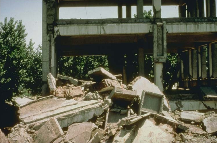
Damage and deaths
Because the earthquake struck at lunchtime when many people were
cooking meals over fire, many people died as a result of the many large
fires that broke out. Some fires developed into
firestorms that swept across cities. Many people died when their feet became stuck in melting
tarmac. The single greatest loss of life was caused by a firestorm-induced
fire whirl
that engulfed open space at the Rikugun Honjo Hifukusho (formerly the
Army Clothing Depot) in downtown Tokyo, where about 38,000 people were
incinerated after taking shelter there following the earthquake. The
earthquake broke
water mains
all over the city, and putting out the fires took nearly two full days
until late in the morning of September 3. An estimated 140,000 people
were killed and 447,000 houses were destroyed by the fire alone.
A strong
typhoon struck
Tokyo Bay at about the same time as the earthquake. Some scientists, including C.F. Brooks of the
United States Weather Bureau, suggested the opposing energy exerted by a sudden decrease of
atmospheric pressure coupled with a sudden increase of sea pressure by a
storm surge on an already-stressed
earthquake fault, known as the Sagami Trough, may have triggered the earthquake. Winds from the typhoon caused fires off the coast of
Noto Peninsula in
Ishikawa Prefecture to spread rapidly.
The
Emperor and
Empress were staying at
Nikko when the earthquake struck Tokyo, and were never in any danger.
Many homes were buried or swept away by
landslides in the mountainous and hilly coastal areas in western
Kanagawa Prefecture, killing about 800 people. A collapsing mountainside in the village of Nebukawa, west of
Odawara, pushed the entire village and a passenger train carrying over 100 passengers, along with the railway station, into the sea.
A
tsunami with waves up to 10 m (33 ft) high struck the coast of
Sagami Bay,
Boso Peninsula,
Izu Islands, and the east coast of
Izu Peninsula within minutes. The tsunami killed many, including about 100 people along Yui-ga-hama Beach in
Kamakura and an estimated 50 people on the
Enoshima
causeway. Over 570,000 homes were destroyed, leaving an estimated 1.9
million homeless. Evacuees were transported by ship from Kanto to as
far as
Kobe in Kansai. The damage is estimated to have exceeded USD$1 billion (or about $13,475 billion today). There were 57 aftershocks.
Altogether, the earthquake and typhoon killed an estimated 99,300 people, and another 43,500 went missing.
Postquake massacre of ethnic minorities and political opponents
The
Home Ministry declared
martial law, and ordered all sectional police chiefs to make maintenance of order and security a top priority. A rumor spread was that
Koreans were taking advantage of the disaster, committing arson and robbery, and were in possession of bombs.
Anti-Korean sentiment was heightened by fear of the
Korean independence movement, partisans of which were responsible for assassinations of top Japanese officials and other terrorist activity.
In the confusion after the quake, mass murder of Koreans by mobs
occurred in urban Tokyo and Yokohama, fueled by rumors of rebellion and
sabotage.
The government reported 2613 Koreans were killed by mobs in Tokyo and
Yokohama in the first week of September. Independent reports said the
number killed was far higher. Some newspapers reported the rumors as
fact, including the allegation that Koreans were poisoning wells. The
numerous fires and cloudy well water, a little-known effect of a large
quake, all seemed to confirm the rumors of the panic-stricken survivors
who were living amidst the rubble.
Vigilante groups set up roadblocks in cities, and tested residents with a
shibboleth
for supposedly Korean-accented Japanese: deporting, beating, or
killing those who failed. Army and police personnel colluded in the
vigilante killings in some areas. Of the 3,000 Koreans taken into
custody at the Army Cavalry Regiment base in
Narashino,
Chiba Prefecture, 10% were killed at the base, or after being released
into nearby villages. Moreover, anyone mistakenly identified as Korean,
such as Chinese,
Okinawans, and Japanese speakers of some regional dialects, suffered the same fate. About 700 Chinese, mostly from
Wenzhou, were killed. A monument commemorating this was built in 1993 in Wenzhou.
In response, the government called upon the
Japanese Army
and the police to detain Koreans to defuse the situation; 23.715
Koreans were detained across Japan, 12.000 in Tokyo alone. The chief of
police of
Tsurumi (or
Kawasaki
by some accounts) is reported to have publicly drunk the well water to
disprove the rumor that Koreans had been poisoning wells. In some
towns, even police stations into which Korean people had escaped were
attacked by mobs, whereas in other neighbourhoods, residents took steps
to protect them. The Army distributed flyers denying the rumor and
warning civilians against attacking Koreans, but in many cases
vigilante activity only ceased as a result of Army operations against
it. As Allen notes, the Japanese colonial occupation of Korea provided
the backdrop to this extreme example of the explosion of racial
prejudice into violence, based on a history of antagonism. To be a
Korean in 1923 Japan was to be not only despised, but also threatened
and possibly killed.
Amidst the mob violence against Koreans in the Kantō Region, regional
police and the Imperial Army used the pretext of civil unrest to
liquidate political dissidents.
Socialists such as
Hirasawa Keishichi,
anarchists such as
Sakae Osugi and
Noe Ito, and the Chinese communal leader,
Ou Kiten,
were abducted and killed by local police and Imperial Army, who
claimed the radicals intended to use the crisis as an opportunity to
overthrow the Japanese government.
The importance of obtaining and providing accurate information
following natural disasters has been emphasized in Japan ever since.
Earthquake preparation literature in modern Japan almost always directs
citizens to carry a portable radio and use it to listen to reliable
information, and not to be misled by rumors in the event of a large
earthquake.
Aftermath
Following the devastation of the earthquake, some in the government
considered the possibility of moving the capital elsewhere. Proposed
sites for the new capital were even discussed.
Japanese commentators interpreted the disaster as an act of divine (
Kami)
punishment to admonish the Japanese people for their self-centered,
immoral, and extravagant lifestyles. In the long run, the response to
the disaster was a strong sense that Japan had been given an
unparalleled opportunity to rebuild the city, and to rebuild Japanese
values. In reconstructing the city, the nation, and the Japanese people,
the earthquake fostered a culture of catastrophe and reconstruction
that amplified discourses of moral degeneracy and national renovation in
interwar Japan.
After the earthquake,
Gotō Shimpei organized a reconstruction plan of Tokyo with modern networks of
roads,
trains, and public services.
Parks
were placed all over Tokyo as refuge spots, and public buildings were
constructed with stricter standards than private buildings to
accommodate refugees. However, the outbreak of
World War II and subsequent destruction severely limited resources.
Frank Lloyd Wright received credit for designing the
Imperial Hotel, Tokyo,
to withstand the quake, although in fact the building was damaged by
the shock. The destruction of the US embassy caused Ambassador
Cyrus Woods
to relocate the embassy to the hotel. Wright's structure withstood the
anticipated earthquake stresses, and the hotel remained in use until
1968.
The unfinished
battlecruiser Amagi was in drydock being converted into an
aircraft carrier in
Yokosuka in compliance with the
Washington Naval Treaty of 1922. However, the earthquake damaged the
Amagi beyond repair, leading it to be scrapped, and the unfinished fast battleship
Kaga was converted into an aircraft carrier in its place.
In contrast to London, where typhoid fever had been steadily declining
since the 1870s, the rate in Tokyo remained high, more so in the
upper-class residential northern and western districts than in the
densely populated working-class eastern district. An explanation is the
decline of waste disposal, which became particularly serious in the
northern and western districts when traditional methods of waste
disposal collapsed due to urbanization. The 1923 earthquake led to
record-high morbidity due to unsanitary conditions following the
earthquake, and it prompted the establishment of antityphoid measures
and the building of urban infrastructure.
Memory
Beginning in 1960, every September 1 is designated as
Disaster Prevention Day
to commemorate the earthquake and remind people of the importance of
preparation, as September and October are the middle of the typhoon
season. Schools and public and private organizations host disaster
drills. Tokyo is located near a
fault zone beneath the
Izu peninsula
which, on average, causes a major earthquake about once every 70 years,
and is also located near the Sagami Trough, a large subduction zone
that threatens to create a massive earthquake that, in the darkest case,
would kill millions in the Kanto Region. Every year on this date,
schools across Japan take a moment of silence at the precise time the
earthquake hit in memory of the lives lost.
Some discreet memorials are located in
Yokoamicho Park in
Sumida Ward,
at the site of the open space in which an estimated 38,000 people were
killed by a single firestorm. The park houses a Buddhist-style
memorial hall/museum, a memorial bell donated by Taiwanese Buddhists, a
memorial to the victims of
World War II Tokyo air raids, and a memorial to the Korean victims of the vigilante killings.