Mostrar mensagens com a etiqueta crise sísmica. Mostrar todas as mensagens

segunda-feira, dezembro 16, 2024

A crise sísmica de New Madrid, nos Estados Unidos, começou há 213 anos

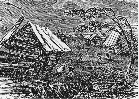
The Great Earthquake at New Madrid, a 19th-century woodcut from Devens' Our First Century (1877)
      
The 1811–1812 New Madrid earthquakes were an intense intraplate earthquake series beginning with an initial earthquake of moment magnitude (7,5 -7,9) on December 16, 1811 followed by a moment magnitude 7,4 aftershock on the same day. They remain the most powerful earthquakes to hit the contiguous United States east of the Rocky Mountains in recorded history. They, as well as the seismic zone of their occurrence, were named for the Mississippi River town of New Madrid, then part of the Louisiana Territory, now within Missouri.
There are estimates that the earthquakes were felt strongly over roughly 130,000 square kilometers, and moderately across nearly 3 million square kilometers. The 1906 San Francisco earthquake, by comparison, was felt moderately over roughly 16,000 km2.
  
New Madrid fault and earthquake-prone region considered at high risk today
  
 The three earthquakes and their major aftershocks
  • December 16, 1811, 08.15 UTC (2:15 a.m.); (M 7,5 -7,9) epicenter in northeast Arkansas. It caused only slight damage to manmade structures, mainly because of the sparse population in the epicentral area. The future location of Memphis, Tennessee, experienced level IX shaking on the Mercalli intensity scale. A seismic seiche propagated upriver, and Little Prairie (a village that was on the site of the former Fort San Fernando, near the site of present-day Caruthersville, Missouri) was heavily damaged by soil liquefaction.
  • December 16, 1811 (aftershock), 14.15 UTC (8:15 a.m.); (M 7,4) epicenter in northeast Arkansas. This shock followed the first earthquake by five hours and was similar in intensity.
  • January 23, 1812, 15.00 UTC (9:00 a.m.); (M 7,3 -7,6) epicenter in the Missouri Bootheel. The meizoseismal area was characterized by general ground warping, ejections, fissuring, severe landslides, and caving of stream banks. Johnson and Schweig attributed this earthquake to a rupture on the New Madrid North Fault. This may have placed strain on the Reelfoot Fault.
  • February 7, 1812, 09.45 UTC (3:45 a.m.); (M 7,5 -8,0) epicenter near New Madrid, Missouri. New Madrid was destroyed. In St. Louis, Missouri, many houses were severely damaged, and their chimneys were toppled. This shock was definitively attributed to the Reelfoot Fault by Johnston and Schweig. Uplift along a segment of this reverse fault created temporary waterfalls on the Mississippi at Kentucky Bend, created waves that propagated upstream, and caused the formation of Reelfoot Lake by obstructing streams in what is now Lake County, Tennessee.
Susan Hough, a seismologist of the United States Geological Survey (USGS), has estimated the earthquakes' magnitudes as around magnitude 7.
There were many more aftershocks including one magnitude 7 aftershock to December 16, 1811 earthquake which occurred on December 17, 1811 at 0600 UTC (12:00 a.m.) and one magnitude 7 aftershock to February 7, 1812 earthquake which occurred on the same day at 0440 UTC (10:40 p.m.).
  
Eyewitness accounts
John Bradbury, a Fellow of the Linnean Society, was on the Mississippi on the night of December 15, 1811, and describes the tremors in great detail in his Travels in the Interior of America in the Years 1809, 1810 and 1811, published in 1817.
After supper, we went to sleep as usual: about ten o'clock, and in the night I was awakened by the most tremendous noise, accompanied by an agitation of the boat so violent, that it appeared in danger of upsetting ... I could distinctly see the river as if agitated by a storm; and although the noise was inconceivably loud and terrific, I could distinctly hear the crash of falling trees, and the screaming of the wild fowl on the river, but found that the boat was still safe at her moorings.
By the time we could get to our fire, which was on a large flag in the stern of the boat, the shock had ceased; but immediately the perpendicular banks, both above and below us, began to fall into the river in such vast masses, as nearly to sink our boat by the swell they occasioned ... At day-light we had counted twenty-seven shocks.
Eliza Bryan in New Madrid, Territory of Missouri, wrote the following eyewitness account in March 1812.
On the 16th of December, 1811, about two o'clock, a.m., we were visited by a violent shock of an earthquake, accompanied by a very awful noise resembling loud but distant thunder, but more hoarse and vibrating, which was followed in a few minutes by the complete saturation of the atmosphere, with sulphurious vapor, causing total darkness. The screams of the affrighted inhabitants running to and fro, not knowing where to go, or what to do—the cries of the fowls and beasts of every species—the cracking of trees falling, and the roaring of the Mississippi— the current of which was retrograde for a few minutes, owing as is supposed, to an irruption in its bed— formed a scene truly horrible.
John Reynolds (February 26, 1788 – May 8, 1865) who was the 4th governor of Illinois, among other political posts, mentions the earthquake in his biography My Own Times: Embracing Also the History of My Life (1855):
On the night of 16th November [sic], 1811, an earthquake occurred, that produced great consternation amongst the people. The centre of the violence was in New Madrid, Missouri, but the whole valley of the Mississippi was violently agitated. Our family all were sleeping in a log cabin, and my father leaped out of bed crying aloud "the Indians are on the house" ... We laughed at the mistake of my father, but soon found out it was worse than the Indians. Not one in the family knew at the time that it was an earthquake. The next morning another shock made us acquainted with it, so we decided it was an earthquake. The cattle came running home bellowing with fear, and all animals were terribly alarmed on the occasion. Our house cracked and quivered, so we were fearful it would fall to the ground. In the American Bottom many chimneys were thrown down, and the church bell in Cahokia sounded by the agitation of the building. It is said the shock of an earthquake was felt in Kaskaskia in 1804, but I did not perceive it. The shocks continued for years in Illinois, and some have experienced it this year, 1855.
The Shaker diarist Samuel Swan McClelland described the effects of the earthquake on the Shaker settlement at West Union (Busro), Indiana, where the earthquakes contributed to the temporary abandonment of the westernmost Shaker community.
     
Reelfoot Rift
    
Geologic setting
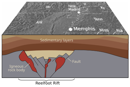
The underlying cause of the earthquakes is not well understood, but modern faulting seems to be related to an ancient geologic feature buried under the Mississippi River alluvial plain, known as the Reelfoot Rift. The New Madrid Seismic Zone (NMSZ) is made up of reactivated faults that formed when what is now North America began to split or rift apart during the breakup of the supercontinent Rodinia in the Neoproterozoic Era (about 750 million years ago). Faults were created along the rift and igneous rocks formed from magma that was being pushed towards the surface. The resulting rift system failed but has remained as an aulacogen (a scar or zone of weakness) deep underground.
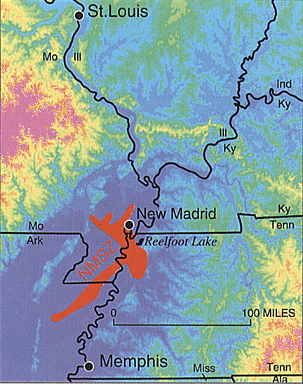
In recent decades minor earthquakes have continued. The epicenters of over 4,000 earthquakes can be identified from seismic measurements taken since 1974. It can be seen that they originate from the seismic activity of the Reelfoot Rift. The zone which is colored in red on the map is called the New Madrid Seismic Zone. New forecasts estimate a 7 to 10 percent chance, in the next 50 years, of a repeat of a major earthquake like those that occurred in 1811–1812, which likely had magnitudes of between 7,6 and 8,0. There is a 25 to 40 percent chance, in a 50-year time span, of a magnitude 6,0 or greater earthquake.
In a report filed in November 2008, the U.S. Federal Emergency Management Agency warned that a serious earthquake in the New Madrid Seismic Zone could result in "the highest economic losses due to a natural disaster in the United States," further predicting "widespread and catastrophic" damage across Alabama, Arkansas, Illinois, Indiana, Kentucky, Mississippi, Missouri, and particularly Tennessee, where a 7,7 magnitude quake or greater would cause damage to tens of thousands of structures affecting water distribution, transportation systems, and other vital infrastructure.
    
4000 earthquake reports since 1974
      

segunda-feira, março 04, 2024

Crise sísmico-vulcânica na Terceira (Vulcão de Santa Bárbara) - ponto da situação...

  
CRISE SISMOVULCÂNICA DA TERCEIRA E ESTRUTURAS ADJACENTES
- VULCÃO DE SANTA BÁRBARA – V2


O Instituto de Vulcanologia da Universidade dos Açores (IVAR), com base na informação obtida através da rede de monitorização gerida pelo Centro de Informação e Vigilância Sismovulcânica dos Açores (CIVISA), informa que a crise sismovulcânica que se vem registando na ilha Terceira desde o dia 24 de junho de 2022 se mantém. 

A atividade sísmica registada no âmbito desta crise tem-se centrado com maior incidência dentro do perímetro do Vulcão de Santa Bárbara e sido caracterizada pela ocorrência de microssismos. Até à data, o evento mais energético ocorreu no dia 30 de abril, pelas 07:17 horas, atingiu a magnitude de 3,6 na Escala de Richter e teve epicentro a cerca de 2 km a E da Serreta, tendo sido sentido na ilha Terceira com intensidade máxima de V na Escala de Mercalli Modificada. 

A sismicidade registada tem abrangido igualmente, embora com menor frequência, o Sistema Vulcânico Fissural da Terceira, de direção aproximada NW-SE, num troço que atravessa a Serra de Santa Bárbara em direção às Furnas do Enxofre. Pontualmente, continua a registar-se alguma atividade sísmica noutras estruturas ativas da ilha Terceira e nos sistemas submarinos adjacentes, sendo de realçar que nos últimos dias, em particular desde 10 de junho, têm sido registados vários microssismos com epicentro na zona de Angra do Heroísmo, ao longo de um alinhamento de direção aproximada NE-SW que se estende desde sul de S. Mateus até à parte central da ilha, e que poderá ter continuidade até às Lajes. 

Até ao momento, com a rede de monitorização existente e o programa de recolha de amostras em curso, não foram detetadas variações significativas em termos de deformação crustal, nem obtidos resultados anómalos ao nível das análises a gases e águas, continuando a decorrer as campanhas de amostragem, o processamento e reprocessamento de dados e a avaliação permanente da situação. 

O facto de a sismicidade se encontrar claramente acima dos valores de referência e estar localizada num aparelho vulcânico com atividade eruptiva histórica justificam a situação de Alerta V2 no Vulcão de Santa Bárbara. 

O fenómeno que está a afetar a ilha Terceira não se pode dissociar do incremento da atividade sismovulcânica que se tem verificado na região dos Açores e, em particular, no Grupo Central, desde o início de 2022, e o padrão de atividade observado indicia a possibilidade de continuarem a ocorrer eventos sentidos pela população, que podem, eventualmente, atingir magnitudes e intensidades superiores às registadas até à data. 

Caso a situação descrita se altere ou sejam obtidos dados que permitam novas interpretações, serão produzidas novas informações. 
 

sábado, dezembro 16, 2023

A estranha crise sísmica de New Madrid começou há 212 anos

The Great Earthquake at New Madrid, a 19th-century woodcut from Devens' Our First Century (1877)
      
The 1811–1812 New Madrid earthquakes were an intense intraplate earthquake series beginning with an initial earthquake of moment magnitude (7,5 -7,9) on December 16, 1811 followed by a moment magnitude 7,4 aftershock on the same day. They remain the most powerful earthquakes to hit the contiguous United States east of the Rocky Mountains in recorded history. They, as well as the seismic zone of their occurrence, were named for the Mississippi River town of New Madrid, then part of the Louisiana Territory, now within Missouri.
There are estimates that the earthquakes were felt strongly over roughly 130,000 square kilometers, and moderately across nearly 3 million square kilometers. The 1906 San Francisco earthquake, by comparison, was felt moderately over roughly 16,000 km2.
  
New Madrid fault and earthquake-prone region considered at high risk today
  
 The three earthquakes and their major aftershocks
  • December 16, 1811, 08.15 UTC (2:15 a.m.); (M 7,5 -7,9) epicenter in northeast Arkansas. It caused only slight damage to manmade structures, mainly because of the sparse population in the epicentral area. The future location of Memphis, Tennessee, experienced level IX shaking on the Mercalli intensity scale. A seismic seiche propagated upriver, and Little Prairie (a village that was on the site of the former Fort San Fernando, near the site of present-day Caruthersville, Missouri) was heavily damaged by soil liquefaction.
  • December 16, 1811 (aftershock), 14.15 UTC (8:15 a.m.); (M 7,4) epicenter in northeast Arkansas. This shock followed the first earthquake by five hours and was similar in intensity.
  • January 23, 1812, 15.00 UTC (9:00 a.m.); (M 7,3 -7,6) epicenter in the Missouri Bootheel. The meizoseismal area was characterized by general ground warping, ejections, fissuring, severe landslides, and caving of stream banks. Johnson and Schweig attributed this earthquake to a rupture on the New Madrid North Fault. This may have placed strain on the Reelfoot Fault.
  • February 7, 1812, 09.45 UTC (3:45 a.m.); (M 7,5 -8,0) epicenter near New Madrid, Missouri. New Madrid was destroyed. In St. Louis, Missouri, many houses were severely damaged, and their chimneys were toppled. This shock was definitively attributed to the Reelfoot Fault by Johnston and Schweig. Uplift along a segment of this reverse fault created temporary waterfalls on the Mississippi at Kentucky Bend, created waves that propagated upstream, and caused the formation of Reelfoot Lake by obstructing streams in what is now Lake County, Tennessee.
Susan Hough, a seismologist of the United States Geological Survey (USGS), has estimated the earthquakes' magnitudes as around magnitude 7.
There were many more aftershocks including one magnitude 7 aftershock to December 16, 1811 earthquake which occurred on December 17, 1811 at 0600 UTC (12:00 a.m.) and one magnitude 7 aftershock to February 7, 1812 earthquake which occurred on the same day at 0440 UTC (10:40 p.m.).
  
Eyewitness accounts
John Bradbury, a Fellow of the Linnean Society, was on the Mississippi on the night of December 15, 1811, and describes the tremors in great detail in his Travels in the Interior of America in the Years 1809, 1810 and 1811, published in 1817.
After supper, we went to sleep as usual: about ten o'clock, and in the night I was awakened by the most tremendous noise, accompanied by an agitation of the boat so violent, that it appeared in danger of upsetting ... I could distinctly see the river as if agitated by a storm; and although the noise was inconceivably loud and terrific, I could distinctly hear the crash of falling trees, and the screaming of the wild fowl on the river, but found that the boat was still safe at her moorings.
By the time we could get to our fire, which was on a large flag in the stern of the boat, the shock had ceased; but immediately the perpendicular banks, both above and below us, began to fall into the river in such vast masses, as nearly to sink our boat by the swell they occasioned ... At day-light we had counted twenty-seven shocks.
Eliza Bryan in New Madrid, Territory of Missouri, wrote the following eyewitness account in March 1812.
On the 16th of December, 1811, about two o'clock, a.m., we were visited by a violent shock of an earthquake, accompanied by a very awful noise resembling loud but distant thunder, but more hoarse and vibrating, which was followed in a few minutes by the complete saturation of the atmosphere, with sulphurious vapor, causing total darkness. The screams of the affrighted inhabitants running to and fro, not knowing where to go, or what to do—the cries of the fowls and beasts of every species—the cracking of trees falling, and the roaring of the Mississippi— the current of which was retrograde for a few minutes, owing as is supposed, to an irruption in its bed— formed a scene truly horrible.
John Reynolds (February 26, 1788 – May 8, 1865) who was the 4th governor of Illinois, among other political posts, mentions the earthquake in his biography My Own Times: Embracing Also the History of My Life (1855):
On the night of 16th November [sic], 1811, an earthquake occurred, that produced great consternation amongst the people. The centre of the violence was in New Madrid, Missouri, but the whole valley of the Mississippi was violently agitated. Our family all were sleeping in a log cabin, and my father leaped out of bed crying aloud "the Indians are on the house" ... We laughed at the mistake of my father, but soon found out it was worse than the Indians. Not one in the family knew at the time that it was an earthquake. The next morning another shock made us acquainted with it, so we decided it was an earthquake. The cattle came running home bellowing with fear, and all animals were terribly alarmed on the occasion. Our house cracked and quivered, so we were fearful it would fall to the ground. In the American Bottom many chimneys were thrown down, and the church bell in Cahokia sounded by the agitation of the building. It is said the shock of an earthquake was felt in Kaskaskia in 1804, but I did not perceive it. The shocks continued for years in Illinois, and some have experienced it this year, 1855.
The Shaker diarist Samuel Swan McClelland described the effects of the earthquake on the Shaker settlement at West Union (Busro), Indiana, where the earthquakes contributed to the temporary abandonment of the westernmost Shaker community.
     
Reelfoot Rift
    
Geologic setting
The underlying cause of the earthquakes is not well understood, but modern faulting seems to be related to an ancient geologic feature buried under the Mississippi River alluvial plain, known as the Reelfoot Rift. The New Madrid Seismic Zone (NMSZ) is made up of reactivated faults that formed when what is now North America began to split or rift apart during the breakup of the supercontinent Rodinia in the Neoproterozoic Era (about 750 million years ago). Faults were created along the rift and igneous rocks formed from magma that was being pushed towards the surface. The resulting rift system failed but has remained as an aulacogen (a scar or zone of weakness) deep underground.
In recent decades minor earthquakes have continued. The epicenters of over 4,000 earthquakes can be identified from seismic measurements taken since 1974. It can be seen that they originate from the seismic activity of the Reelfoot Rift. The zone which is colored in red on the map is called the New Madrid Seismic Zone. New forecasts estimate a 7 to 10 percent chance, in the next 50 years, of a repeat of a major earthquake like those that occurred in 1811–1812, which likely had magnitudes of between 7,6 and 8,0. There is a 25 to 40 percent chance, in a 50-year time span, of a magnitude 6,0 or greater earthquake.
In a report filed in November 2008, the U.S. Federal Emergency Management Agency warned that a serious earthquake in the New Madrid Seismic Zone could result in "the highest economic losses due to a natural disaster in the United States," further predicting "widespread and catastrophic" damage across Alabama, Arkansas, Illinois, Indiana, Kentucky, Mississippi, Missouri, and particularly Tennessee, where a 7,7 magnitude quake or greater would cause damage to tens of thousands of structures affecting water distribution, transportation systems, and other vital infrastructure.
    
4000 earthquake reports since 1974
      

quinta-feira, abril 13, 2023

A falha de New Madrid está outra vez a mexer...?!?

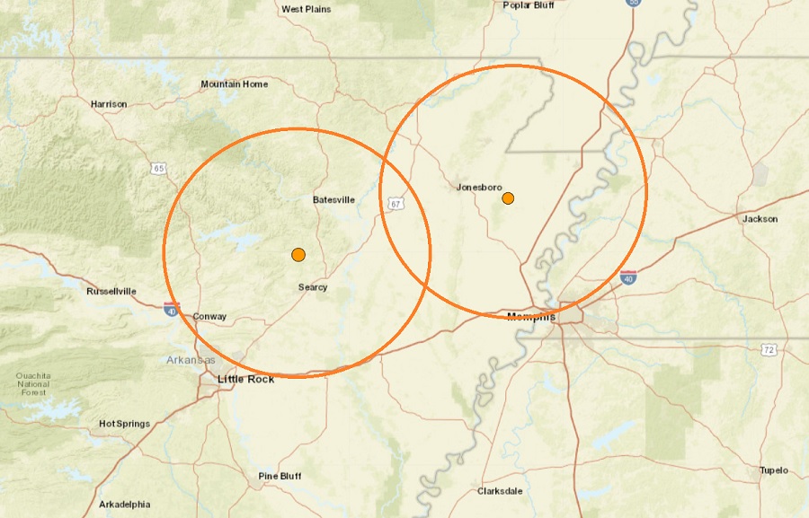
The epicenter of both earthquake to hit Arkansas today is at the orange dot located within the broader orange circle


Pair of Weak Earthquakes Rattle Arkansas, Not Far from New Madrid Fault Zone


The New Madrid Seismic zone remains active and another large earthquake strong enough to shake the entire eastern United States continues to loom


sábado, março 04, 2023

A crise sísmico-vulcânica em S. Jorge - ponto da situação...


O Centro de Informação e Vigilância Sismovulcânica dos Açores (CIVISA) informa que a atividade sismovulcânica que se tem vindo a registar na ilha de S. Jorge desde as 16.05 (hora local = UTC-1) do dia 19 de março de 2022 continua acima do normal, estendendo-se, grosso modo, ao longo de uma faixa com direção WNW-ESE, desde a Ponta dos Rosais até à zona do Norte Pequeno – Silveira.

Até ao momento, foram registados aproximadamente 56.801 eventos de baixa magnitude e de origem tectónica. Entre as 00.00 e as 10.00 de hoje foram contabilizados aproximadamente 2 sismos. O sismo mais energético desta crise ocorreu no dia 29 de março de 2022, às 21.56 (hora local = UTC), teve epicentro a cerca de 2 km a SSW de Velas e uma magnitude 3,8 (Richter). Até ao momento foram identificados cerca de 347 sismos sentidos pela população.​

Globalmente, a atividade sísmica das últimas semanas apresenta uma ligeira tendência decrescente, por vezes interrompida por pequenos períodos de maior frequência e/ou energia libertada, situando-se presentemente os hipocentros, no geral, a profundidades superiores a 5 km.

No âmbito da monitorização geodésica, os dados existentes desde o início de abril não evidenciam deformação significativa na zona epicentral.

As campanhas de medição de gases e temperatura no solo que se vêm desenvolvendo desde o início desta crise na área epicentral não resultaram, até à data, na identificação de anomalias resultantes da atividade sismovulcânica, mantendo-se os levantamentos de campo.

As campanhas de hidrogeoquímica nas águas subterrâneas dos dois furos de captação monitorizados (Queimada II e Ribeira do Nabo - IROA) não têm revelado variações significativas que possam ser associadas à crise sismovulcânica em curso.

A integração da informação disponível permite concluir que as estruturas tectónicas onde se desenvolveram as erupções históricas de 1580 e 1808, e a crise sismovulcânica de 1964, no Sistema Vulcânico Fissural de Manadas, foram reativadas, sendo de admitir que no início do fenómeno ocorreu uma intrusão magmática em profundidade.

A diminuição da atividade sísmica, ainda que de forma lenta, e a observação de tal padrão ao longo das últimas semanas, assim como a ausência de outros sinais anómalos ao nível da deformação, dos gases e das águas, levaram o CIVISA a determinar, no dia 9 de junho de 2022, às 09:20, a descida do Nível de Alerta Científico de V4 para V3 na ilha de S. Jorge. A atividade sísmica continua, no entanto, muito acima dos valores de referência para a região, pelo que se mantém a possibilidade de se registarem eventos sentidos e não se pode excluir a eventual ocorrência de sismos de magnitude mais elevada.

O CIVISA mantém os níveis de monitorização na ilha de S. Jorge e está a providenciar o reforço da rede de observação sismovulcânica permanente, no sentido de, caso o padrão de atividade se inverta, poder detetar sinais precursores de uma nova situação pré-eruptiva.

Alertas anteriores:
Alerta V2 – Dia 20 de março de 2022 às 00.40;
Alerta V3 – Dia 20 de março de 2022 às 02.40;
Alerta V4 – Dia 23 de março de 2022 às 15.30;
Alerta V3 – Dia 09 de junho de 2022, às 09.20.

O CIVISA retirou igualmente o alerta para o Centro de Controlo Aéreo de Santa Maria (ACC Santa Maria), para o Volcanic Ash Advisory Centre (VAAC) de Toulouse e para o Instituto Português do Mar e da Atmosfera (IPMA).


in CIVISA

sexta-feira, dezembro 16, 2022

A crise sísmica de New Madrid começou há 211 anos

The Great Earthquake at New Madrid, a 19th-century woodcut from Devens' Our First Century (1877)
      
The 1811–1812 New Madrid earthquakes were an intense intraplate earthquake series beginning with an initial earthquake of moment magnitude (7,5 -7,9) on December 16, 1811 followed by a moment magnitude 7,4 aftershock on the same day. They remain the most powerful earthquakes to hit the contiguous United States east of the Rocky Mountains in recorded history. They, as well as the seismic zone of their occurrence, were named for the Mississippi River town of New Madrid, then part of the Louisiana Territory, now within Missouri.
There are estimates that the earthquakes were felt strongly over roughly 130,000 square kilometers, and moderately across nearly 3 million square kilometers. The 1906 San Francisco earthquake, by comparison, was felt moderately over roughly 16,000 km2.
  
New Madrid fault and earthquake-prone region considered at high risk today
  
 The three earthquakes and their major aftershocks
  • December 16, 1811, 08.15 UTC (2:15 a.m.); (M 7,5 -7,9) epicenter in northeast Arkansas. It caused only slight damage to manmade structures, mainly because of the sparse population in the epicentral area. The future location of Memphis, Tennessee, experienced level IX shaking on the Mercalli intensity scale. A seismic seiche propagated upriver, and Little Prairie (a village that was on the site of the former Fort San Fernando, near the site of present-day Caruthersville, Missouri) was heavily damaged by soil liquefaction.
  • December 16, 1811 (aftershock), 14.15 UTC (8:15 a.m.); (M 7,4) epicenter in northeast Arkansas. This shock followed the first earthquake by five hours and was similar in intensity.
  • January 23, 1812, 15.00 UTC (9:00 a.m.); (M 7,3 -7,6) epicenter in the Missouri Bootheel. The meizoseismal area was characterized by general ground warping, ejections, fissuring, severe landslides, and caving of stream banks. Johnson and Schweig attributed this earthquake to a rupture on the New Madrid North Fault. This may have placed strain on the Reelfoot Fault.
  • February 7, 1812, 09.45 UTC (3:45 a.m.); (M 7,5 -8,0) epicenter near New Madrid, Missouri. New Madrid was destroyed. In St. Louis, Missouri, many houses were severely damaged, and their chimneys were toppled. This shock was definitively attributed to the Reelfoot Fault by Johnston and Schweig. Uplift along a segment of this reverse fault created temporary waterfalls on the Mississippi at Kentucky Bend, created waves that propagated upstream, and caused the formation of Reelfoot Lake by obstructing streams in what is now Lake County, Tennessee.
Susan Hough, a seismologist of the United States Geological Survey (USGS), has estimated the earthquakes' magnitudes as around magnitude 7.
There were many more aftershocks including one magnitude 7 aftershock to December 16, 1811 earthquake which occurred on December 17, 1811 at 0600 UTC (12:00 a.m.) and one magnitude 7 aftershock to February 7, 1812 earthquake which occurred on the same day at 0440 UTC (10:40 p.m.).
  
Eyewitness accounts
John Bradbury, a Fellow of the Linnean Society, was on the Mississippi on the night of December 15, 1811, and describes the tremors in great detail in his Travels in the Interior of America in the Years 1809, 1810 and 1811, published in 1817.
After supper, we went to sleep as usual: about ten o'clock, and in the night I was awakened by the most tremendous noise, accompanied by an agitation of the boat so violent, that it appeared in danger of upsetting ... I could distinctly see the river as if agitated by a storm; and although the noise was inconceivably loud and terrific, I could distinctly hear the crash of falling trees, and the screaming of the wild fowl on the river, but found that the boat was still safe at her moorings.
By the time we could get to our fire, which was on a large flag in the stern of the boat, the shock had ceased; but immediately the perpendicular banks, both above and below us, began to fall into the river in such vast masses, as nearly to sink our boat by the swell they occasioned ... At day-light we had counted twenty-seven shocks.
Eliza Bryan in New Madrid, Territory of Missouri, wrote the following eyewitness account in March 1812.
On the 16th of December, 1811, about two o'clock, a.m., we were visited by a violent shock of an earthquake, accompanied by a very awful noise resembling loud but distant thunder, but more hoarse and vibrating, which was followed in a few minutes by the complete saturation of the atmosphere, with sulphurious vapor, causing total darkness. The screams of the affrighted inhabitants running to and fro, not knowing where to go, or what to do—the cries of the fowls and beasts of every species—the cracking of trees falling, and the roaring of the Mississippi— the current of which was retrograde for a few minutes, owing as is supposed, to an irruption in its bed— formed a scene truly horrible.
John Reynolds (February 26, 1788 – May 8, 1865) who was the 4th governor of Illinois, among other political posts, mentions the earthquake in his biography My Own Times: Embracing Also the History of My Life (1855):
On the night of 16th November [sic], 1811, an earthquake occurred, that produced great consternation amongst the people. The centre of the violence was in New Madrid, Missouri, but the whole valley of the Mississippi was violently agitated. Our family all were sleeping in a log cabin, and my father leaped out of bed crying aloud "the Indians are on the house" ... We laughed at the mistake of my father, but soon found out it was worse than the Indians. Not one in the family knew at the time that it was an earthquake. The next morning another shock made us acquainted with it, so we decided it was an earthquake. The cattle came running home bellowing with fear, and all animals were terribly alarmed on the occasion. Our house cracked and quivered, so we were fearful it would fall to the ground. In the American Bottom many chimneys were thrown down, and the church bell in Cahokia sounded by the agitation of the building. It is said the shock of an earthquake was felt in Kaskaskia in 1804, but I did not perceive it. The shocks continued for years in Illinois, and some have experienced it this year, 1855.
The Shaker diarist Samuel Swan McClelland described the effects of the earthquake on the Shaker settlement at West Union (Busro), Indiana, where the earthquakes contributed to the temporary abandonment of the westernmost Shaker community.
     
Reelfoot Rift
    
Geologic setting
The underlying cause of the earthquakes is not well understood, but modern faulting seems to be related to an ancient geologic feature buried under the Mississippi River alluvial plain, known as the Reelfoot Rift. The New Madrid Seismic Zone (NMSZ) is made up of reactivated faults that formed when what is now North America began to split or rift apart during the breakup of the supercontinent Rodinia in the Neoproterozoic Era (about 750 million years ago). Faults were created along the rift and igneous rocks formed from magma that was being pushed towards the surface. The resulting rift system failed but has remained as an aulacogen (a scar or zone of weakness) deep underground.
In recent decades minor earthquakes have continued. The epicenters of over 4,000 earthquakes can be identified from seismic measurements taken since 1974. It can be seen that they originate from the seismic activity of the Reelfoot Rift. The zone which is colored in red on the map is called the New Madrid Seismic Zone. New forecasts estimate a 7 to 10 percent chance, in the next 50 years, of a repeat of a major earthquake like those that occurred in 1811–1812, which likely had magnitudes of between 7,6 and 8,0. There is a 25 to 40 percent chance, in a 50-year time span, of a magnitude 6,0 or greater earthquake.
In a report filed in November 2008, the U.S. Federal Emergency Management Agency warned that a serious earthquake in the New Madrid Seismic Zone could result in "the highest economic losses due to a natural disaster in the United States," further predicting "widespread and catastrophic" damage across Alabama, Arkansas, Illinois, Indiana, Kentucky, Mississippi, Missouri, and particularly Tennessee, where a 7,7 magnitude quake or greater would cause damage to tens of thousands of structures affecting water distribution, transportation systems, and other vital infrastructure.
    
4000 earthquake reports since 1974
      

domingo, junho 12, 2022

A crise sísmico-vulcânica em S. Jorge - baixou o risco de erupção

Atividade Sísmica na ilha de S. Jorge - atualização

09.06.2022 - 13.20


O Centro de Informação e Vigilância Sismovulcânica dos Açores (CIVISA) informa que a crise sismovulcânica que se tem vindo a registar na ilha de S. Jorge desde as 16:05 (hora local = UTC-1) do dia 19 de março continua acima do normal, estendendo-se, grosso modo, ao longo de uma faixa com direção WNW-ESE, desde a Ponta dos Rosais até à zona do Norte Pequeno – Silveira.

Até ao momento (10:00 hora local = UTC), foram registados aproximadamente 37.411 eventos de baixa magnitude e de origem tectónica. O sismo mais energético desta crise ocorreu no dia 29 de março, às 21:56 (hora local = UTC), teve epicentro a cerca de 2 km a SSW de Velas e uma magnitude 3,8 (Richter). Até ao momento foram identificados cerca de 287 sismos sentidos pela população.
 
Globalmente, a atividade sísmica das últimas semanas apresenta uma ligeira tendência decrescente, por vezes interrompida por pequenos períodos de maior frequência e/ou energia libertada, situando-se presentemente os hipocentros, no geral, a profundidades superiores a 5 km.
 
No âmbito da monitorização geodésica, os dados existentes desde o início de abril não evidenciam deformação significativa na zona epicentral.
 
As campanhas de medição de gases e temperatura no solo que se vêm desenvolvendo desde o início desta crise na área epicentral não resultaram, até à data, na identificação de anomalias resultantes da atividade sismovulcânica, mantendo-se os levantamentos de campo.
 
As campanhas de hidrogeoquímica nas águas subterrâneas dos dois furos de captação monitorizados (Queimada II e Ribeira do Nabo - IROA) não têm revelado variações significativas que possam ser associadas à crise sismovulcânica em curso.
 
A integração da informação disponível permite concluir que as estruturas tectónicas onde se desenvolveram as erupções históricas de 1580 e 1808, e a crise sismovulcânica de 1964, no Sistema Vulcânico Fissural de Manadas, foram reativadas, sendo de admitir que no início do fenómeno ocorreu uma intrusão magmática em profundidade. 
 
A diminuição da atividade sísmica, ainda que de forma lenta, e a observação de tal padrão ao longo das últimas semanas, assim como a ausência de outros sinais anómalos ao nível da deformação, dos gases e das águas, levaram o CIVISA a determinar a descida do Nível de Alerta Científico de V4 para V3 na ilha de S. Jorge. A atividade sísmica continua, no entanto, muito acima dos valores de referência para a região, pelo que se mantém a possibilidade de se registarem eventos sentidos e não se pode excluir a eventual ocorrência de sismos de magnitude mais elevada.
 
O CIVISA mantém os níveis de monitorização na ilha de S. Jorge e está a providenciar o reforço da rede de observação sismovulcânica permanente, no sentido de, caso o padrão de atividade se inverta, poder detetar sinais precursores de uma nova situação pré-eruptiva.

Alertas anteriores:
Alerta V4 – Dia 23 de março às 15h30;
Alerta V3 – Dia 20 de março às 02h40;
Alerta V2 – Dia 20 de março às 00h40.


O CIVISA retirou igualmente o alerta para o Centro de Controlo Aéreo de Santa Maria (ACC Santa Maria), para o Volcanic Ash Advisory Centre (VAAC) de Toulouse e para o Instituto Português do Mar e da Atmosfera (IPMA).


in CIVISA

sábado, maio 14, 2022

E a crise sísmico-vulcânica em S. Jorge continua...


Sismos sentidos na ilha de São Jorge (ponto de situação, 13-05-2022, 22:00) 
 

O Centro de Informação e Vigilância Sismovulcânica dos Açores (CIVISA) informa que atividade sísmica que se tem vindo a registar desde as 16:05 (hora local = UTC-1) do dia 19 de março na ilha de São Jorge, mais concretamente ao longo de uma faixa com direção WNW-ESE, desde a Ponta dos Rosais até à zona do Norte Pequeno - Silveira, continua acima do normal.


O sismo mais energético ocorreu no dia 29 de março, às 21:56 (hora local = UTC) e teve magnitude 3,8 (Richter).

Até ao momento foram identificados cerca de 273 sismos sentidos pela população. Desde as 10:00 às 22:00 do dia 13 de maio não foi sentido nenhum sismo.

O CIVISA continua a acompanhar o evoluir da situação


in CIVISA

quarta-feira, abril 13, 2022

A crise sísmico-vulcânica em S. Jorge continua...


São Jorge 

Sismos sentidos na ilha de São Jorge - ponto de situação, 13.04.2022, 10.00 horas 


O Centro de Informação e Vigilância Sismovulcânica dos Açores (CIVISA) informa que atividade sísmica que se tem vindo a registar desde as 16:05 (hora local = UTC-1) do dia 19 de março na ilha de São Jorge, mais concretamente ao longo de uma faixa com direção WNW-ESE, desde a Ponta dos Rosais até à zona do Norte Pequeno - Silveira, continua acima do normal.


O sismo mais energético ocorreu no dia 29 de março, às 21.56 (hora local) e teve magnitude 3,8 (Richter).

Até ao momento foram identificados cerca de 244 sismos sentidos pela população. Desde as 20.00 do dia 12 de abril às 10.00 horas do dia 13 de abril, foram sentidos 2 sismos:
 
 
Dia Hora local Mag. Epicentro Int. (EMM) Freguesia
12.04 20.41 2,3 8 km WSW Velas III Urzelina (Velas, S. Jorge)
13.04 08.15 2,3 7 km WSW Velas III/IV Santo Amaro (Velas, S. Jorge)
III Rosais (Velas, S. Jorge)
 
O CIVISA continua a acompanhar o evoluir da situação.


in CIVISA

domingo, abril 03, 2022

A crise sísmico-vulcânica em S. Jorge - notícia interessante com erro grave no título

São Jorge já registou quase 25 mil sismos. Geólogos apanharam susto e recearam a “destruição total”


Foram registados quase 25 mil sismos na ilha de São Jorge, nos Açores, desde o início da crise sismo-vulcânica. 221 destes foram sentidos pela população que continua a preparar-se para o pior. Nos últimos dias, os geólogos apanharam um susto e temeram a “destruição total” nas Velas.

O presidente do Centro de Informação e Vigilância Sismo-vulcânica dos Açores (CIVISA), Rui Marques, revela aos jornalistas que “foram registados 24.919 sismos até às 10:30″ horas desta sexta-feira desde 19 de março passado, quando começou a crise sismo-vulcânica.

Rui Marques diz que a população sentiu 221 desse total de sismos e que, desde a meia-noite até às 10 horas de sexta-feira, mais nenhum foi sentido pelos residentes.

Este responsável refere que a média é agora de “800 sismos por dia”, o que “ainda é uma frequência diária muitíssimo acima do que é normal nos Açores”.

A maior parte da sismicidade na ilha de São Jorge situa-se “no sistema fissural vulcânico de Manadas”, entre a vila de Velas e a Fajã do Ouvidor, explica ainda Rui Marques.

Na Ponta dos Rosais foram registados sete eventos, “com menor profundidade”, diz também.

O presidente do CIVISA repara que, para já, “é difícil perceber” a ligação entre a zona das Velas onde a crise sísmica tem tido maior frequência e os “sete eventos da Ponta dos Rosais”.

“De forma preventiva”, foi determinada a interdição do Farol dos Rosais, como explica à Lusa o presidente da Proteção Civil açoriana, Eduardo Faria. Os agricultores que usam os terrenos para a pastagem de animais “já foram avisados” de que não é aconselhável passar ou permanecer naquela zona, nota este responsável.

Eduardo Faria também frisa que, na quinta-feira, houve uma “significativa redução da quantidade de sismos”, numa “alteração de padrão” para a qual não “há, para já, nenhuma explicação”.


Erupção terrestre pode “causar a destruição total”

Na quarta-feira, os geólogos que têm observado os sismos que estão a ocorrer em São Jorge apanharam um susto, mas “foi falso alarme”, como assume o professor de Geologia na Faculdade de Ciências da Universidade de Lisboa (FCUL), José Madeira, em declarações ao Nascer do Sol.

Houve receios de uma erupção depois de se ter sentido o sismo mais forte desde o início da crise, de magnitude 3.8 na escala de Richter.

“Parecia que a coisa ia começar a propagar-se para a superfície, mas foi falso alarme”, destaca José Moreira.

Esse sismo “causou uma perturbação do sistema”, “mas entretanto houve uma certa diminuição da frequência dos sismos, que já voltaram à profundidade inicial, entre os 10 e os 13 km”, salienta o também investigador do Instituto D. Luiz.

Continuam em cima da mesa três hipóteses: a crise sísmica passar simplesmente, haver um sismo mais forte e que cause danos ou ocorrer uma erupção vulcânica.

No caso de haver erupção, pode ser terrestre ou marítima, a maior ou menor profundidade. Se surgir a menos de 200 metros de profundidade, “aí o principal perigo é a grande produção de cinzas vulcânicas“, explica José Moreira ao Nascer do Sol.

Essa situação pode “justificar uma evacuação da zona mais próxima do centro eruptivo”, diz.

Em caso de erupção terrestre, se “houver derrame lávico nas vertentes sobranceiras” a Velas, “aí pode mesmo causar a destruição total desta”, aponta ainda o professor de Geologia.


Já foi concluído o plano de retirada da população

Mais de 2500 pessoas já saíram de Velas e já está concluído o plano de retirada da população para o caso de haver um episódio de maior magnitude – sismo ou erupção vulcânica, como explica o presidente da Proteção Civil açoriana.

“Estão definidos todos os caminhos de evacuação“, aponta Eduardo Faria.

Este responsável também nota que estão a ser feitos “refrescamentos de ações de formação” aos operacionais no terreno para atuação em situações de catástrofe.

Por outro lado, o “campo militar está completamente autónomo, com capacidade total”, acrescenta Eduardo Faria.

Foi ainda feita uma reunião com as forças de segurança sobre as zonas de triagem e acolhimento de população, caso seja necessário fazer uma evacuação.

São Jorge continua com um nível de alerta vulcânico V4 (ameaça de erupção) de um total de sete, em que V0 significa “estado de repouso” e V6 “erupção em curso”.

Segundo os dados provisórios dos Censos 2021, a ilha de São Jorge tem 8.373 habitantes, dos quais 4.936 no concelho das Velas e 3.437 no concelho da Calheta.


Missas retomadas apesar do perigo

Apesar dos receios, verifica-se “alguma acalmia” e a população deve “voltar à normalidade”, mantendo-se “vigilante”. Por isso, as celebrações religiosas estão a ser retomadas no concelho das Velas, como explica o padre António Azevedo.

“Passado o susto inicial, é o voltar à normalidade, porque não se sabe o tempo que isto vai levar. O objectivo é transmitir calma e apoio à população e voltarmos à nossa vida e tentarmos celebrar a Semana Santa dentro dos possíveis”, sublinhou o pároco em declarações à agência Lusa.

No fim de semana, as celebrações estiveram interditadas nas fajãs e foram desaconselhadas em todas as igrejas do concelho das Velas por precaução.

As imagens das igrejas foram removidas dos seus locais habituais e foi cancelada a procissão que deveria ter ocorrido na tarde de domingo, na freguesia da Urzelina.

“No sábado e no domingo, não se sabia o que iria acontecer e não houve missa, porque houve um êxodo da população e também não era aconselhável juntar pessoas. Nas Velas, nem pessoas tinha para as celebrações. Mas mantiveram-se as missas noutras zonas da ilha onde era possível”, explica ainda o padre António Azevedo.

Agora, as missas são retomadas após uma reunião do Administrador Diocesano com o clero da ilha de São Jorge esta semana.

“Sabemos que as igrejas são edifícios antigos e há o caso da igreja da Urzelina, cujo teto está a precisar de obras. Torna-se perigoso, mas não vou impedir“, salienta o pároco, aconselhando a população a “manter o distanciamento para que, em caso de sismo, se possam proteger”.


in ZAP


NOTA: há uma certa diferença entre  a destruição total de UMA ILHA ou da destruição total de uma VILA (Velas)...

A crise sísmico-vulcânica em S. Jorge - aparente acalmia


São Jorge

Sismos sentidos na ilha de São Jorge - ponto de situação, 03.04.2022, 10.00


O Centro de Informação e Vigilância Sismovulcânica dos Açores (CIVISA) informa que atividade sísmica que se tem vindo a registar desde as 16.05 (hora local = UTC-1) do dia 19 de março na parte central da ilha de São Jorge, mais concretamente ao longo de uma faixa com direção WNW-ESE, num setor compreendido entre Velas e Fajã do Ouvidor, continua acima do normal.

O sismo mais energético ocorreu no dia 29 de março, às 21:56 (hora local = UTC) e teve magnitude 3,8 (Richter).

Até ao momento foram identificados cerca de 225 sismos sentidos pela população. Desde as 22.00 do dia 2 de abril  às 10.00 horas do dia 3 de abril, não foi sentido nenhum sismo pela população.
O CIVISA continua a acompanhar o evoluir da situação.


Fontes: IVAR/CIVISA

sexta-feira, abril 01, 2022

A crise sísmico-vulcânica em S. Jorge - alteração, rumo à Ponta dos Rosais, da atividade sísmica...


Mapa dos epicentros de sismos em São Jorge nos últimos cinco dias - fonte CIVISA

A crise sísmico-vulcânica em S. Jorge - alterações interessantes...


Açores 

Crise sísmica em São Jorge: “situação nova” com alterações na localização dos sismos 

 Lusa 1 de abril de 2022, 0:52


Foram registados sismos na zona dos Rosais, na parte mais ocidental da ilha, e com focos mais próximos da superfície.

O presidente da Protecção Civil açoriana disse esta quinta-feira que os focos dos sismos registados na nova zona da crise sismo-vulcânica de São Jorge, nos Rosais, foram registados mais próximos da superfície, entre os cinco a sete quilómetros de profundidade.

Em declarações à agência Lusa, o brigadeiro-general Eduardo Faria disse que o registo de sismos na zona dos Rosais, na parte mais ocidental da ilha, é uma “situação nova”.

Desde o início da crise sísmica em São Jorge, no dia 19, que os sismos se têm vindo a registar na parte central da ilha, numa área que vai desde o centro de Velas até à Fajã do Ouvidor.

Já no briefing diário sobre a situação, o presidente do Serviço Regional de Proteção Civil e Bombeiros dos Açores tinha revelado a existência de “uma alteração relativamente à localização dos epicentros” dos sismos. “Essas coisas não se podem prever onde vai ser, mas estar-se-ia mais à espera que continuasse na mesma linha que se tinha verificado nos últimos dias.”

Segundo disse, os sismos na zona dos Rosais têm ocorrido mais próximos da superfície, uma vez que o hipocentro tem sido registado entre os “cinco a sete quilómetros de profundidade”. 

Já os eventos ocorridos na zona central da ilha continuam com profundidade de “7,5 a 12 quilómetros”.

Eduardo Faria acrescentou que os técnicos do Centro de Informação e Vigilância Sismovulcânica dos Açores (CIVISA) estão a “analisar a situação”, uma vez que ainda não se “conhece inteiramente” o “contexto dos sismos registados” desde quinta-feira à noite na zona dos Rosais.

Face a essa situação, a Protecção Civil está a “avaliar” a possibilidade de impedir o acesso à zona mais ocidental da ilha, nos Rosais.

“Está-se a avaliar as condições de segurança daquela zona mais ocidental da ilha, olhando para as condições de estabilidade e para a possibilidade de vedar aquela zona, sobretudo a zona próxima do farol, para salvaguardar qualquer dano pessoal”, acrescentou, referindo-se ao Farol da Ponta dos Rosais.

O Farol da Ponta dos Rosais entrou em funcionamento em 1958, mas está ao abandono desde 1980, depois de ter sido fustigado por vários eventos de natureza sísmica ao longo dos anos.

A ilha de São Jorge contabilizou mais de 14 mil sismos desde o início da crise sísmica a 19 de Março, segundo os dados oficiais mais recentes — um número que é mais do dobro do total contabilizado em toda a região autónoma dos Açores durante o ano 2021.

Cerca de 2.500 pessoas já saíram do concelho das Velas, centro da crise sísmica, das quais 1.500 por via aérea e marítima, e as restantes para o concelho vizinho da Calheta, considerado mais seguro pelos especialistas.

A ilha está com o nível de alerta vulcânico V4 (ameaça de erupção) de um total de sete, em que V0 significa “estado de repouso” e V6 “erupção em curso”.


in Público

quinta-feira, março 31, 2022

Notícia sobre a crise sísmico-vulcânica em S. Jorge...


Dimensão, profundidade, velocidade do fenómeno? O que aproxima e separa as crises sismo-vulcânicas de São Jorge e de La Palma


Fenómeno que atinge a ilha açoriana faz lembrar o vulcão que há alguns meses nasceu em La Palma, mas há diferenças relevantes

A ocorrência de milhares de sismos em poucos dias é uma das semelhanças entre a crise sismo-vulcânica que em setembro de 2021 atingiu as Canárias, em La Palma, e a crise sismo-vulcânica que está a atingir São Jorge, nos Açores.

Os dois fenómenos têm pontos em comum, mas também têm diferenças relevantes, como explica Luca D'Auria à CNN Portugal.

Começando pelas semelhanças, o diretor da Área de Vigilância Vulcânica do Instituto Vulcanológico das Canárias explica que pelas estimativas que fazem - limitadas por não terem um conhecimento dos Açores tão próximo como têm de La Palma - o volume de magma debaixo das duas ilhas será parecido: cerca de 20 milhões de metros cúbicos de magma.

Contudo, a partir daí são várias as diferenças que separam os dois fenómenos, nomeadamente na distância do magma para a superfície.

Em La Palma o magma estava muito próximo da superfície no momento em que começaram os sismos, enquanto que em São Jorge o magma que se move nas fissuras e pode provocar um vulcão estará a alguns quilómetros de profundidade.

Em São Jorge, na semana passada, foram detetados sinais, através de imagens de radar, que indicam que o terreno se pode ter deformado alguns centímetros, algo que também ocorreu em La Palma antes da erupção vulcânica, mas a diferença é que na ilha do arquipélago espanhol das Canárias tudo foi muito rápido: "A deformação começou cinco dias antes da erupção e em São Jorge tudo parece estar a ocorrer de forma muito mais lenta", detalha o especialista, que admite que a diferença estará, exatamente, na profundidade a que se move o magma.

Por outro lado, aquilo que pode ocorrer em São Jorge ainda é completamente incerto, mas Luca D'Auria admite que na maioria dos casos, ao contrário do que aconteceu em La Palma, os enxames de sismos provocados pelos movimentos de magma no subsolo não causam erupções vulcânicas.

A crise sismo-vulcânica começou nos Açores a 19 de março e em cerca de dez dias registaram-se mais de 8.000 sismos de pequena e média intensidade.

Segundo o Instituto Português do Mar e da Atmosfera (IPMA), a tendência até ao inicio da noite do dia 29 apontava no sentido de um ligeiro decréscimo nos valores de magnitude e também numa redução do ritmo de libertação de energia sísmica, mas pelas 21.56 horas de dia 29 ocorreu o sismo com maior magnitude (4.0 na escala de Richter), num abalo que ocorreu a uma profundidade de 12 quilómetros e que foi registado a um quilómetro a sul da vila de Velas.


in CNN Portugal

quarta-feira, março 30, 2022

A crise sísmico-vulcânica em S. Jorge - breve resumo

Freguesia de Santo Amaro, na ilha açoriana de São Jorge, uma das mais afetadas pela crise sísmica


Crise sísmica em São Jorge. Especialistas alertam para sinais idênticos aos do vulcão de La Palma


O Instituto Vulcanológico das Canárias (Involcan) alerta que a crise sísmica em São Jorge, nos Açores, tem origem vulcânica e não tectónica como se supunha. Especialistas desta entidade detectaram sinais de magma semelhantes aos que antecederam a erupção do vulcão Cumbre Vieja em La Palma, em 2021.

 O alerta vulcânico mantém-se no nível V4 em São Jorge, de um total de sete, o que indicia que há uma possibilidade de erupção – V6 significa “erupção em curso”. Esse cenário é vincado por dados divulgados pelo Involcan, cujos vulcanologistas detetaram um volume de magma semelhante ao registado antes da erupção do vulcão Cumbre Vieja no ano passado.

“Através da análise de dados do radar de abertura sintética adquiridos pelo satélite Sentinel-1 da Agência Espacial Europeia, pôde observar-se que, durante as últimas semanas, esta ilha experimentou uma deformação do terreno compatível com uma fonte de natureza vulcânica“, aponta o Involcan.

Os especialistas espanhóis usaram uma técnica de “interferometria de satélite” que “compara as imagens de radar obtidas em duas datas diferentes para detetar variações de fase que poderiam estar associadas com as deformações no relevo da superfície terrestre”, como explica o Involcan.

Assim, foi detetada “uma intrusão magmática ao longo de uma fratura subvertical (dique)”, com um “volume estimado” de “cerca de 20 milhões de metros cúbicos, um valor comparável com o que se observou pela deformação do terreno antes da erupção do Cumbre Vieja em 2021″, aponta ainda o Instituto espanhol.


 “A situação pode mudar de forma repentina”

O investigador do Involcan Lucas Dauria explica ao Expresso que estamos perante uma deformação “bastante relevante”, com cerca de 13 centímetros e que “não é apenas um levantamento do terreno, mas também um deslocamento para norte e para sul”.

Lucas Dauria também nota que a situação em São Jorge está a ser mais lenta do que em La Palma, onde “a crise sísmica até à erupção durou uma semana e a deformação no terreno foi observada poucos dias antes da erupção”.

Contudo, o especialista repara que não é certo que a erupção venha de facto a acontecer na ilha açoriana. “A situação pode mudar de forma repentina”, nota Dauria.

“Neste momento, o número de sismos está a diminuir e se o magma não tiver energia suficiente para chegar à superfície pode estancar onde se encontra. Julgo que isso é o mais provável, mas não se pode descartar a possibilidade de uma erupção nos próximos dias ou semanas”, acrescenta o investigador.

Também o diretor do Centro de Informação e Vigilância Sismovulcânica dos Açores (CIVISA), Rui Marques, salienta ao Expresso que há dois cenários possíveis: “um sismo de maior magnitude, que pode causar estragos, ou uma erupção, que pode ser em Terra, semelhante à de La Palma, ou submarina“, tal como ocorreu na ilha em 1964.

Rui Marques frisa que houve “uma ligeira diminuição” na actividade sísmica a partir do dia 24 de Março, mas continua-se “a registar uma sismicidade muito acima do normal para este sistema vulcânico (de São Jorge)”. “Estamos a registar uma média de mil sismos por dia, que continua a ser extremamente elevada”, aponta o responsável do CIVISA.

Perante este cenário, o presidente do Serviço Regional de Proteção Civil e Bombeiros dos Açores, Eduardo Faria, sublinha, em declarações à RTP Açores, que esta acalmia pode levar a “uma falsa sensação de segurança”.


São Jorge sentiu o abalo maior desde início da crise

Nesta terça-feira à noite, São Jorge sentiu um sismo de magnitude 3.8 na escala de Richter. Foi o abalo mais forte desde 19 de Março, quando se iniciou a crise sismo-vulcânica, e também foi sentido nas ilhas do Pico, Faial, Terceira e Graciosa.

Fonte do Serviço Regional de Bombeiros e Proteção Civil dos Açores adianta à Lusa que “não há registo de danos”.

Segundo os dados do CIVISA, o sismo ocorreu às 21:56 (22:56 de Lisboa) e teve epicentro no mar, junto à vila das Velas.

A ilha de São Jorge contabilizou mais de 20 mil sismos, cerca de 200 dos quais sentidos pela população, desde o início da crise sísmica em 19 de março passado. Trata-se de mais do dobro do total contabilizado em toda a Região Autónoma dos Açores durante o ano de 2021.

Veja no vídeo que se segue, divulgado pelo Instituto Português de Meteorologia, os eventos sísmicos ocorridos em São Jorge entre 19 e 29 de março de 2022.


in ZAP