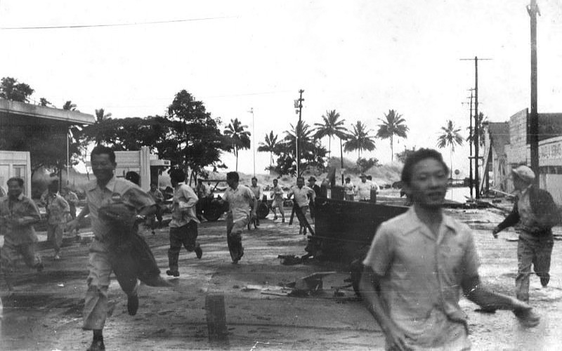
Fourth Avenue in Anchorage, Alaska,
looking east from near Barrow Street. The southern edge of one of
several landslides in Anchorage, this one covered an area of over a
dozen blocks, including 5 blocks along the north side of Fourth Avenue.
Most of the area was razed and made an urban renewal district
The 1964 Alaskan earthquake, also known as the Great Alaskan Earthquake, the Portage Earthquake and the Good Friday Earthquake, was a megathrust earthquake that began at 5:36 P.M. AST on Good Friday, March 27, 1964. Across south-central Alaska, ground fissures, collapsing structures, and tsunamis resulting from the earthquake caused about 143 deaths.
Lasting nearly three minutes, it was the most powerful recorded earthquake in U.S. and North American history, and the second most powerful ever measured by seismograph. It had a magnitude of 9.2, making it the second largest earthquake in recorded history.
The powerful earthquake produced earthquake liquefaction
in the region. Ground fissures and failures caused major structural
damage in several communities, much damage to property and several
landslides. Anchorage sustained great destruction or damage to many inadequately engineered
houses, buildings, and infrastructure (paved streets, sidewalks,
water and sewer mains, electrical systems, and other man-made
equipment), particularly in the several landslide zones along Knik
Arm. Two hundred miles southwest, some areas near Kodiak were
permanently raised by 30 feet (9.1 m). Southeast of Anchorage, areas
around the head of Turnagain Arm near Girdwood
and Portage dropped as much as 8 feet (2.4 m), requiring
reconstruction and fill to raise the Seward Highway above the new high tide mark.
In Prince William Sound, Port Valdez suffered a massive underwater
landslide, resulting in the deaths of 30 people between the collapse of
the Valdez city harbor and docks, and inside the ship that was docked there at the time. Nearby, a 27-foot (8.2 m) tsunami destroyed the village of Chenega,
killing 23 of the 68 people who lived there; survivors out-ran the
wave, climbing to high ground. Post-quake tsunamis severely affected
Whittier, Seward, Kodiak, and other Alaskan communities, as well as
people and property in British Columbia, Oregon, and California.
Tsunamis also caused damage in Hawaii and Japan. Evidence of motion
directly related to the earthquake was reported from all over the earth.

Geology
At 5:36 p.m. Alaska Standard Time (3:36 a.m. March 28, 1964 UTC), a fault between the Pacific and North American plates ruptured near College Fjord in Prince William Sound. The epicenter of the earthquake was 61.05°N 147.48°W, 12.4 mi (20 km) north of Prince William Sound, 78 miles (125 km) east of Anchorage and 40 miles (64 km) west of Valdez. The focus occurred at a depth of approximately 15.5 mi (25 km). Ocean floor shifts created large tsunamis
(up to 220 feet (67 m) in height), which resulted in many of the deaths
and much of the property damage. Large rockslides were also caused,
resulting in great property damage. Vertical displacement of up to 38 feet (11.5 m) occurred, affecting an area of 100,000 miles² (250,000 km²) within Alaska.
Studies of ground motion have led to a peak ground acceleration estimate of 0.14 - 0.18 g.
The Alaska Earthquake was a subduction zone earthquake (megathrust earthquake), caused by an oceanic plate sinking under a continental plate. The fault responsible was the Aleutian Megathrust,
a reverse fault caused by a compressional force. This caused much of
the uneven ground which is the result of ground shifted to the
opposite elevation.

Calculated travel time map for the tectonic tsunami produced by the 1964 Prince William Sound earthquake in Alaska
Death toll, damage and casualties
Various sources indicate that about 131 people died as a result of the
earthquake: nine as a result of earthquake itself, 106 from subsequent
tsunamis in Alaska and 16 from tsunamis in Oregon and California. Property damage was estimated at over $310 million ($2.25 billion in current U.S. dollars).
Most damage occurred in Anchorage, 75 mi (120 km) northwest of the epicenter. Anchorage was not hit by tsunamis, but downtown Anchorage was heavily damaged, and parts of the city built on sandy bluffs overlying "Bootlegger Cove clay" near Cook Inlet, most notably the Turnagain neighborhood, suffered landslide
damage. The neighborhood lost 75 houses in the landslide, and the
destroyed area has since been turned into Earthquake Park. The
Government Hill school suffered from the Government Hill landslide
leaving it in two jagged, broken pieces. Land overlooking the Ship Creek
valley near the Alaska Railroad yards also slid, destroying many
acres of buildings and city blocks in downtown Anchorage. Most other
areas of the city were only moderately damaged. The 60-foot concrete
control tower at Anchorage International Airport was not engineered to withstand earthquake activity and collapsed, killing one employee.
The house at 918 W. 10th Avenue suffered damage peripherally, but one
block away the recently completed and still unoccupied Four Seasons
Building on Ninth Avenue collapsed completely with one whole wing
sticking up out of the rubble like a seesaw.
The hamlets of Girdwood and Portage, located 30 and 40 mi (60 km) southeast of central Anchorage on the Turnagain Arm,
were destroyed by subsidence and subsequent tidal action. Girdwood
was relocated inland and Portage was abandoned. About 20 miles (32 km)
of the Seward Highway sank below the high-water mark of Turnagain
Arm; the highway and its bridges were raised and rebuilt in 1964-66.

Elsewhere in Alaska
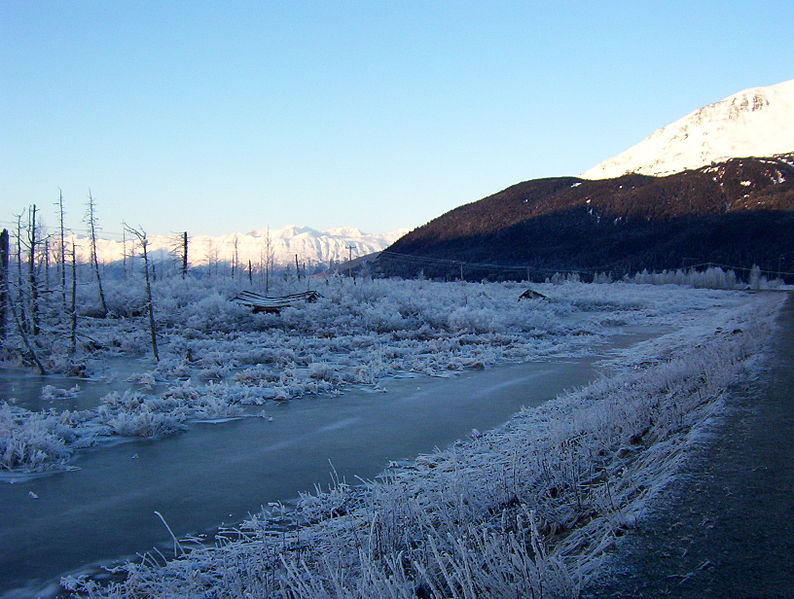
A winter scene of a "Ghost forest"
that was killed and preserved by salt water along with ruined
buildings at the site of the former town of Portage, 2011
Elsewhere in Alaska
Most coastal towns in the Prince William Sound, Kenai Peninsula, and Kodiak Island areas, especially the major ports of Seward, Whittier and Kodiak were heavily damaged by a combination of seismic activity, subsidence, post-quake tsunamis and/or earthquake-caused fires.
Valdez was not totally destroyed, but after three years, the town
relocated to higher ground 7 km (4 mi) west of its original site. Some Alaska native villages, including Chenega and Afognak, were destroyed or damaged. The earthquake caused the Cold-War era ballistic missile detection radar of Clear Air Force Station to go offline for six minutes, the only unscheduled interruption in its operational history. Near Cordova, the Million Dollar Bridge
crossing the Copper River also collapsed. The community of Girdwood
was also confined to the southern side of the Seward Highway when water
rushed into Turnagain Arm arm and flooded or destroyed any buildings
left standing to the north of the highway. Interestingly, only the
ground immediately along the highway and that on the north side of the
road dropped, prompting geologists to speculate that Girdwood may rest
upon an ancient cliff face, now covered by countless thousands of
years of sediment and glacial deposits.
Canada
A 4.5 ft (1.4 m) wave reached Prince Rupert, British Columbia, just south of the Alaska Panhandle, about three hours after the quake. The tsunami then reached Tofino, on the exposed west coast of Vancouver Island, and traveled up a fjord to hit Port Alberni twice, washing away 55 homes and damaging 375 others. The towns of Hot Springs Cove, Zeballos, and Amai also saw damage. The damage in British Columbia was estimated at $10 million Canadian ($65 million in 2006 Canadian dollars, or $56 million in 2006 U.S. dollars).
Elsewhere
Twelve people were killed by the tsunami in or near Crescent City, California, while four children were killed on the Oregon coast at Beverly Beach State Park. Other towns along the U.S. Pacific Northwest and Hawaii were damaged. Minor damage to boats reached as far south as Los Angeles.
As the entire planet vibrated as a result of the quake, minor effects were felt worldwide. Several fishing boats were sunk in Louisiana, and water sloshed in wells in Africa.
Aftershocks
There were thousands of aftershocks for three weeks, following the main shock. In the first day alone, eleven major aftershocks were recorded with a magnitude greater than 6.2. Nine more occurred over the next three weeks. It was not until more than a year later that the aftershocks were no longer noticed.
in Wikipédia


.jpg/1920px-Alaska_Purchase_(hi-res).jpg)