Mostrar mensagens com a etiqueta crise sísmica. Mostrar todas as mensagens

segunda-feira, março 28, 2022

A crise sísmico-vulcânica em S. Jorge - novo ponto da situação

  
São Jorge

Sismos sentidos na ilha de São Jorge - ponto de situação, 28.03.22, 10:00

O Centro de Informação e Vigilância Sismovulcânica dos Açores (CIVISA) informa que atividade sísmica que se tem vindo a registar desde as 16:05 (hora local = UTC-1) do dia 19 de março na parte central da ilha de São Jorge, mais concretamente ao longo de uma faixa com direção WNW-ESE, num setor compreendido entre Velas e Fajã do Ouvidor, continua acima do normal.

O sismo mais energético ocorreu no dia 19 de março, às 18:41 (hora local = UTC-1) e teve magnitude 3,3 (Richter).

Até ao momento foram identificados cerca de 207 sismos sentidos pela população. Desde as 22:00 do dia 27 de março às 10:00 do dia 28 de março, foram sentidos 5 sismos:
 
Dia Hora local Mag. Localização Int. (EMM) Freguesia
27/mar 23:02 1,9 1 km ENE Velas III Santo Amaro e Velas (Velas, S. Jorge)
27/mar 23:25 1,7 1 km NW Santo Amaro III Velas (Velas, S. Jorge)
28/mar 07:38 2,1 3 km NNW Urzelina III/IV Velas e Rosais (Velas, São Jorge)
28/mar 08:56 2,1 2 km WNW Velas III/IV Santo Amaro e Rosais (Velas, S. Jorge)
28/mar 08:57 2,6 2 km WNW Velas IV Velas e Santo Amaro (Velas, S. Jorge)
III Urzelina e Rosais (Velas, S. Jorge)
   
O CIVISA continua a acompanhar o evoluir da situação.


Fontes: IVAR/CIVISA

 
Nota: O IVAR solicita a todos os açorianos que participem num estudo sobre o domínio social do risco no arquipélago perante a eminência de sismo forte ou erupção vulcânica na Ilha de São Jorge. Será um contributo muito valioso para o conhecimento científico nesta matéria.

O estudo é da responsabilidade da equipa de Psicologia do IVAR. Os dados obtidos são anónimos e o preenchimento do questionário dura cerca de 8 minutos.

O questionário online está disponível no link:

domingo, março 27, 2022

Ponto da situação da crise sísmico-vulcânica em S. Jorge

 
São Jorge

Sismos sentidos na ilha de São Jorge - ponto de situação, 27.03.22, 10:00

O Centro de Informação e Vigilância Sismovulcânica dos Açores (CIVISA) informa que atividade sísmica que se tem vindo a registar desde as 16:05 (hora local = UTC-1) do dia 19 de março na parte central da ilha de São Jorge, mais concretamente ao longo de uma faixa com direção WNW-ESE, num setor compreendido entre Velas e Fajã do Ouvidor, continua acima do normal.

O sismo mais energético ocorreu no dia 19 de março, às 18:41 (hora local = UTC-1) e teve magnitude 3,3 (Richter).

Até ao momento foram identificados cerca de 198 sismos sentidos pela população. Desde as 22:00 do dia 26 de março às 10:00 do dia 27 de março, foram sentidos 7 sismos:
 
Dia Hora local Mag. Localização Int. (EMM) Freguesia
26/mar 22:07 2,4 3 km E Santo Amaro IV Velas (Velas, S. Jorge)
III/IV Calheta e Urzelina (Velas, S. Jorge)
26/mar 22:57 2,4 1 km WSW Beira IV Velas e Santo Amaro (Velas, S. Jorge)
III/IV Urzelina (Velas, S. Jorge)
27/mar 01:02 1,9 2 km E Santo Amaro III Urzelina (Velas, S. Jorge)
27/mar 01:42 2,5 1 km NW Santo Amaro III/IV Urzelina, Santo Amaro, Velas e Rosais (Velas, S. Jorge)
III Manadas (Velas, S. Jorge)
27/mar 01:46 2,3 1 km S Beira III Santo Amaro e Velas (Velas, S. Jorge)
27/mar 06:50 2 0,5 km E Velas III Velas (Velas, S. Jorge)
27/mar 09:47 1,7 3 km NNW Urzelina III Urzelina (Velas, S. Jorge)

O CIVISA continua a acompanhar o evoluir da situação.


Fontes: IVAR/CIVISA


sábado, março 26, 2022

Crise sísmico-vulcânica em S. Jorge - ponto da situação


São Jorge
Sismos sentidos na ilha de São Jorge - ponto de situação, 26-03-2022, 10:00


O Centro de Informação e Vigilância Sismovulcânica dos Açores (CIVISA) informa que atividade sísmica que se tem vindo a registar desde as 16:05 (hora local = UTC-1) do dia 19 de março na parte central da ilha de São Jorge, mais concretamente ao longo de uma faixa com direção WNW-ESE, num setor compreendido entre Velas e Fajã do Ouvidor, continua acima do normal.
O sismo mais energético ocorreu no dia 19 de março, às 18:41 (hora local = UTC-1) e teve magnitude 3,3 (Richter).
Vários sismos têm sido sentidos pela população. Desde as 22:00 do dia 25 de março às 10:00 do dia 26 de março, foram sentidos 4 sismos:
 

O CIVISA continua a acompanhar o evoluir da situação.


sexta-feira, março 25, 2022

Mais informações sobre a crise na ilha de São Jorge...

Foram detetadas "pequenas deformações no solo, que no início da semana não existiam", na zona da ilha de São Jorge "onde estão a ocorrer mais sismos". A revelação é feita à CNN Portugal por Nuno Dias, especialista em sismologia e professor no ISEL (Instituto Superior de Engenharia de Lisboa), e Pedro Terrinha, geólogo e investigador do IPMA.

Nuno Dias aponta que, nesta altura, a tendência dos sinais parece caminhar para “o lado da erupção”, mas ainda é cedo para ter a certeza. Os próximos dias serão determinantes.

São estas deformações no solo, juntamente com o mau tempo esperado na região para esta sexta-feira e sábado, que terão levado as autoridades a optar por retirar a população das fajãs do concelho das Velas, na ilha de São Jorge.

Pedro Terrinha confirmou à CNN Portugal que as equipas que estão “a monitorizar a deformação crustal encontraram alguma modificação no terreno”. Ou seja, foram detetadas “deformações localizadas numa zona específica da ilha, que é a zona onde estão a ocorrer mais sismos”, conclui. Mas ainda é cedo para saber ao certo o significado desta descoberta.

De resto, segundo Pedro Terrinha, o elevado nível de “sismicidade continua a acontecer, na mesma zona, com a mesma magnitude baixa e a mesma profundidade”. Nas últimas horas, não houve aumento da atividade sísmica, nem em quantidade, nem em intensidade.

Nuno Dias está a coordenar uma equipa no terreno, ligada ao Instituto D. Luís, que está "a instalar estações sísmicas temporárias". A chuva não está a facilitar a instalação das mesmas, mas já estão a recolher alguns dados e mais irão ser recolhidos.

O que significam estas fraturas nas rochas?

Que o magma que se movimenta por baixo da terra está a fazer pressão. “É como a rolha de uma garrafa. O gás faz pressão para a rolha saltar”, explica Nuno Dias.

No início da semana, não tinha sido detetada nenhuma alteração nos solos e agora a situação parece ter-se alterado ligeiramente. Todavia, Nuno Dias explica que as fraturas "não têm um sinal claro de magma” e estão ainda a grande profundidade, por isso, “o perigo não é iminente”. 

Será possível prever o aumento do perigo?

Para tal, “é preciso juntar vários indicadores” e só “tudo conjugado” poderá dar lugar a um alerta.

“Quando se evolui para uma erupção, há uma altura em que a situação evolui mais rápido”, mas “nunca menos de um, dois dias ou algumas horas”. Facto que dará tempo às autoridades para lançar um alerta à população.

Por norma, “também poderá haver um sismo mais forte, que antecederá uma erupção”. Nunca “será de grande intensidade”, mas “em terra, um sismo de magnitude 4 já causa estragos”.

E quais são esses sinais?

“Uma maior atividade sísmica, com maior intensidade; mais e maiores deformações no solo, com sinal de magma e o aumento da emissão de gases”, explica este especialista. Nuno Dias acredita que as fraturas detetadas levaram as autoridades a pedir a retirada de alguma população e justifica: “Peca-se por excesso, mas é melhor” quando há vidas em risco.

“Os próximos dois/três dias” vão ser determinantes “para se perceber melhor para que lado a situação vai pender”, no entanto, a tendência dos sinais parece caminhar para “o lado da erupção”, assume este sismólogo.

Mesmo assim, a natureza pode ser surpreendente, e é num instante que as certezas desaparecem. “Neste momento, os valores de emissão de gases estão no nível habitual”. Não houve aumento, por exemplo, “do CO2”, que seria um sinal de maior atividade vulcânica.

Este fenómeno sísmico é normal?

Segundo Nuno Dias, o que se está a passar “não é normal” e, desde domingo, que todos os especialistas da área estão a comunicar entre si. Todos querem enviar equipas e material, porque é importante estudar estes fenómenos. E ainda falta algumas equipas chegarem ao terreno.

Nuno Dias descreve a ilha de São Jorge "como um conjunto de pequenos vulcões que formam uma língua de terra”.

Esta região, dos Açores, está “numa junção tripla de placas”, o que a torna propícia a sismos. “É a junção da placa europeia, africana e americana”.

Apesar da região estar a viver uma situação semelhante ao que aconteceu em La Palma, nas Canárias, a sequência de eventos não tem de ser igual.
 
in TVI24

quinta-feira, março 24, 2022

Governo regional açoreano admite uma elevada probabilidade de haver uma erupção em São Jorge

Crise sísmica leva o presidente do governo regional à ilha de São Jorge


O presidente do Governo dos Açores, José Manuel Bolieiro, visitou esta quinta-feira São Jorge devido à crise sísmica que se regista desde sábado na ilha, que já levou à ativação do Plano Regional de Emergência


Na quarta-feira, a Proteção Civil dos Açores ativou o Plano Regional de Emergência, depois de na segunda-feira terem sido ativados os planos de emergência municipais dos dois concelhos de São Jorge, Calheta e Velas.
Também na quarta-feira, o Centro de Informação e Vigilância Sismovulcânica dos Açores (CIVISA) elevou o nível de alerta vulcânico na ilha de São Jorge para V4 (de um total de cinco), o que significa “possibilidade real de erupção”, segundo o Governo Regional.
Perante este cenário, o executivo açoriano recomendou à população com maiores vulnerabilidades da principal zona afetada na ilha de São Jorge que abandone as suas casas.
Desde sábado, já se registaram mais de 2.000 sismos na ilha de São Jorge, 142 dos quais sentidos pela população.

E a crise sísmica prossegue em São Jorge...

  
São Jorge 

Sismos sentidos na ilha de São Jorge (Ponto de situação - 24.03.2022)


O Centro de Informação e Vigilância Sismovulcânica dos Açores (CIVISA) informa que atividade sísmica que se tem vindo a registar desde as 16:05 (hora local = UTC-1) do dia 19 de março na parte central da ilha de São Jorge, mais concretamente ao longo de uma faixa com direção WNW-ESE, num setor compreendido entre Velas e Fajã do Ouvidor, continua acima do normal.


O sismo mais energético ocorreu no dia 1​9 de março, às 18:41 (hora local = UTC-1) e teve magnitude 3,3 (Richter).

Vários sismos têm sido sentidos pela população. Desde as 22:00 do dia 23 de março às 10:00 do dia 24 de março, foram sentidos 11 sismos:
 

Dia

Hora local

Mag.

Localização

Int. (EMM)

Freguesia

23.03

22:23

1,6

3 km NNW Urzelina

III

Urzelina (Velas, S. Jorge)

23.03

22:37

2,1

3 km NNW Urzelina

III/IV

Urzelina e Velas (Velas, S. Jorge)

23.03

22:53

1,9

3 km NW Urzelina

III

Urzelina e Velas (Velas, S. Jorge)

23.03

22:59

2,3

1 km NNW Velas

III/IV

Urzelina, Santo Amaro, Velas e Rosais (Velas, S. Jorge)

23.03

23:11

1,6

3 km N Urzelina

III

Velas (Velas, S. Jorge)

23.03

23:40

2

3 km NNW Urzelina

III/IV

Santo Amaro, Urzelina e Velas (Velas, S. Jorge)

III

Rosais (Velas, S. Jorge)

24.03

00:01

2,2

3 km E Santo Amaro

III/IV

Velas, Rosais, Urzelina e Norte Grande (Velas, S. Jorge)

24.03

00:03

2,2

3 km NNW Urzelina

III/IV

Rosais, Urzelina e Velas (Velas, S. Jorge)

24.03

00:34

1,7

1 km ESSE Beira

III

Velas (Velas, S. Jorge)

24.03

04:10

2

0,5 km NNW de Santo Amaro

III/IV

Velas (Velas, S. Jorge)

24.03

06:39

3,2

2 km WNW Velas

IV/V

Velas e Santo Amaro (Velas, S. Jorge)

IV

Urzelina e Manadas (Velas, S. Jorge)

III/IV

Norte Grande e Rosais (Velas, S. Jorge)

III/IV

Ribeira Seca (Calheta, S. Jorge)

III

Bandeiras (Madalena, Pico)

III

Lajes do Pico (Lajes do Pico, Pico)

III

Santo António, São Roque e Prainha (S. Roque, Pico)

III

Luz (Santa Cruz, Graciosa)


O CIVISA continua a acompanhar o evoluir da situação.

Fonte: IVAR/CIVISA 


quinta-feira, dezembro 16, 2021

A estranha crise sísmica de New Madrid começou há 210 anos

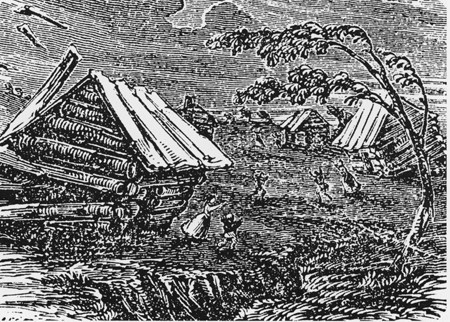
The Great Earthquake at New Madrid, a 19th-century woodcut from Devens' Our First Century (1877)
      
The 1811–1812 New Madrid earthquakes were an intense intraplate earthquake series beginning with an initial earthquake of moment magnitude (7,5 -7,9) on December 16, 1811 followed by a moment magnitude 7,4 aftershock on the same day. They remain the most powerful earthquakes to hit the contiguous United States east of the Rocky Mountains in recorded history. They, as well as the seismic zone of their occurrence, were named for the Mississippi River town of New Madrid, then part of the Louisiana Territory, now within Missouri.
There are estimates that the earthquakes were felt strongly over roughly 130,000 square kilometers, and moderately across nearly 3 million square kilometers. The 1906 San Francisco earthquake, by comparison, was felt moderately over roughly 16,000 km2.
  
New Madrid fault and earthquake-prone region considered at high risk today
  
 The three earthquakes and their major aftershocks
  • December 16, 1811, 08.15 UTC (2:15 a.m.); (M 7,5 -7,9) epicenter in northeast Arkansas. It caused only slight damage to manmade structures, mainly because of the sparse population in the epicentral area. The future location of Memphis, Tennessee, experienced level IX shaking on the Mercalli intensity scale. A seismic seiche propagated upriver, and Little Prairie (a village that was on the site of the former Fort San Fernando, near the site of present-day Caruthersville, Missouri) was heavily damaged by soil liquefaction.
  • December 16, 1811 (aftershock), 14.15 UTC (8:15 a.m.); (M 7,4) epicenter in northeast Arkansas. This shock followed the first earthquake by five hours and was similar in intensity.
  • January 23, 1812, 15.00 UTC (9:00 a.m.); (M 7,3 -7,6) epicenter in the Missouri Bootheel. The meizoseismal area was characterized by general ground warping, ejections, fissuring, severe landslides, and caving of stream banks. Johnson and Schweig attributed this earthquake to a rupture on the New Madrid North Fault. This may have placed strain on the Reelfoot Fault.
  • February 7, 1812, 09.45 UTC (3:45 a.m.); (M 7,5 -8,0) epicenter near New Madrid, Missouri. New Madrid was destroyed. In St. Louis, Missouri, many houses were severely damaged, and their chimneys were toppled. This shock was definitively attributed to the Reelfoot Fault by Johnston and Schweig. Uplift along a segment of this reverse fault created temporary waterfalls on the Mississippi at Kentucky Bend, created waves that propagated upstream, and caused the formation of Reelfoot Lake by obstructing streams in what is now Lake County, Tennessee.
Susan Hough, a seismologist of the United States Geological Survey (USGS), has estimated the earthquakes' magnitudes as around magnitude 7.
There were many more aftershocks including one magnitude 7 aftershock to December 16, 1811 earthquake which occurred on December 17, 1811 at 0600 UTC (12:00 a.m.) and one magnitude 7 aftershock to February 7, 1812 earthquake which occurred on the same day at 0440 UTC (10:40 p.m.).
  
Eyewitness accounts
John Bradbury, a Fellow of the Linnean Society, was on the Mississippi on the night of December 15, 1811, and describes the tremors in great detail in his Travels in the Interior of America in the Years 1809, 1810 and 1811, published in 1817.
After supper, we went to sleep as usual: about ten o'clock, and in the night I was awakened by the most tremendous noise, accompanied by an agitation of the boat so violent, that it appeared in danger of upsetting ... I could distinctly see the river as if agitated by a storm; and although the noise was inconceivably loud and terrific, I could distinctly hear the crash of falling trees, and the screaming of the wild fowl on the river, but found that the boat was still safe at her moorings.
By the time we could get to our fire, which was on a large flag in the stern of the boat, the shock had ceased; but immediately the perpendicular banks, both above and below us, began to fall into the river in such vast masses, as nearly to sink our boat by the swell they occasioned ... At day-light we had counted twenty-seven shocks.
Eliza Bryan in New Madrid, Territory of Missouri, wrote the following eyewitness account in March 1812.
On the 16th of December, 1811, about two o'clock, a.m., we were visited by a violent shock of an earthquake, accompanied by a very awful noise resembling loud but distant thunder, but more hoarse and vibrating, which was followed in a few minutes by the complete saturation of the atmosphere, with sulphurious vapor, causing total darkness. The screams of the affrighted inhabitants running to and fro, not knowing where to go, or what to do—the cries of the fowls and beasts of every species—the cracking of trees falling, and the roaring of the Mississippi— the current of which was retrograde for a few minutes, owing as is supposed, to an irruption in its bed— formed a scene truly horrible.
John Reynolds (February 26, 1788 – May 8, 1865) who was the 4th governor of Illinois, among other political posts, mentions the earthquake in his biography My Own Times: Embracing Also the History of My Life (1855):
On the night of 16th November [sic], 1811, an earthquake occurred, that produced great consternation amongst the people. The centre of the violence was in New Madrid, Missouri, but the whole valley of the Mississippi was violently agitated. Our family all were sleeping in a log cabin, and my father leaped out of bed crying aloud "the Indians are on the house" ... We laughed at the mistake of my father, but soon found out it was worse than the Indians. Not one in the family knew at the time that it was an earthquake. The next morning another shock made us acquainted with it, so we decided it was an earthquake. The cattle came running home bellowing with fear, and all animals were terribly alarmed on the occasion. Our house cracked and quivered, so we were fearful it would fall to the ground. In the American Bottom many chimneys were thrown down, and the church bell in Cahokia sounded by the agitation of the building. It is said the shock of an earthquake was felt in Kaskaskia in 1804, but I did not perceive it. The shocks continued for years in Illinois, and some have experienced it this year, 1855.
The Shaker diarist Samuel Swan McClelland described the effects of the earthquake on the Shaker settlement at West Union (Busro), Indiana, where the earthquakes contributed to the temporary abandonment of the westernmost Shaker community.
     
Reelfoot Rift
    
Geologic setting
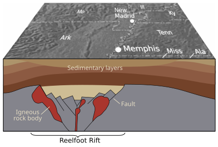
The underlying cause of the earthquakes is not well understood, but modern faulting seems to be related to an ancient geologic feature buried under the Mississippi River alluvial plain, known as the Reelfoot Rift. The New Madrid Seismic Zone (NMSZ) is made up of reactivated faults that formed when what is now North America began to split or rift apart during the breakup of the supercontinent Rodinia in the Neoproterozoic Era (about 750 million years ago). Faults were created along the rift and igneous rocks formed from magma that was being pushed towards the surface. The resulting rift system failed but has remained as an aulacogen (a scar or zone of weakness) deep underground.
In recent decades minor earthquakes have continued. The epicenters of over 4,000 earthquakes can be identified from seismic measurements taken since 1974. It can be seen that they originate from the seismic activity of the Reelfoot Rift. The zone which is colored in red on the map is called the New Madrid Seismic Zone. New forecasts estimate a 7 to 10 percent chance, in the next 50 years, of a repeat of a major earthquake like those that occurred in 1811–1812, which likely had magnitudes of between 7,6 and 8,0. There is a 25 to 40 percent chance, in a 50-year time span, of a magnitude 6,0 or greater earthquake.
In a report filed in November 2008, the U.S. Federal Emergency Management Agency warned that a serious earthquake in the New Madrid Seismic Zone could result in "the highest economic losses due to a natural disaster in the United States," further predicting "widespread and catastrophic" damage across Alabama, Arkansas, Illinois, Indiana, Kentucky, Mississippi, Missouri, and particularly Tennessee, where a 7,7 magnitude quake or greater would cause damage to tens of thousands of structures affecting water distribution, transportation systems, and other vital infrastructure.
    
4000 earthquake reports since 1974
      

quarta-feira, dezembro 16, 2020

A espetacular crise sísmica de New Madrid começou há 209 anos

The Great Earthquake at New Madrid, a 19th-century woodcut from Devens' Our First Century (1877)
   
The 1811–1812 New Madrid earthquakes were an intense intraplate earthquake series beginning with an initial earthquake of moment magnitude (7,5 -7,9) on December 16, 1811 followed by a moment magnitude 7,4 aftershock on the same day. They remain the most powerful earthquakes to hit the contiguous United States east of the Rocky Mountains in recorded history. They, as well as the seismic zone of their occurrence, were named for the Mississippi River town of New Madrid, then part of the Louisiana Territory, now within Missouri.
There are estimates that the earthquakes were felt strongly over roughly 130,000 square kilometers, and moderately across nearly 3 million square kilometers. The 1906 San Francisco earthquake, by comparison, was felt moderately over roughly 16,000 km2.


New Madrid fault and earthquake-prone region considered at high risk today

 The three earthquakes and their major aftershocks
  • December 16, 1811, 08.15 UTC (2:15 a.m.); (M 7,5 -7,9) epicenter in northeast Arkansas. It caused only slight damage to manmade structures, mainly because of the sparse population in the epicentral area. The future location of Memphis, Tennessee, experienced level IX shaking on the Mercalli intensity scale. A seismic seiche propagated upriver, and Little Prairie (a village that was on the site of the former Fort San Fernando, near the site of present-day Caruthersville, Missouri) was heavily damaged by soil liquefaction.
  • December 16, 1811 (aftershock), 14.15 UTC (8:15 a.m.); (M 7,4) epicenter in northeast Arkansas. This shock followed the first earthquake by five hours and was similar in intensity.
  • January 23, 1812, 15.00 UTC (9:00 a.m.); (M 7,3 -7,6) epicenter in the Missouri Bootheel. The meizoseismal area was characterized by general ground warping, ejections, fissuring, severe landslides, and caving of stream banks. Johnson and Schweig attributed this earthquake to a rupture on the New Madrid North Fault. This may have placed strain on the Reelfoot Fault.
  • February 7, 1812, 09.45 UTC (3:45 a.m.); (M 7,5 -8,0) epicenter near New Madrid, Missouri. New Madrid was destroyed. In St. Louis, Missouri, many houses were severely damaged, and their chimneys were toppled. This shock was definitively attributed to the Reelfoot Fault by Johnston and Schweig. Uplift along a segment of this reverse fault created temporary waterfalls on the Mississippi at Kentucky Bend, created waves that propagated upstream, and caused the formation of Reelfoot Lake by obstructing streams in what is now Lake County, Tennessee.
Susan Hough, a seismologist of the United States Geological Survey (USGS), has estimated the earthquakes' magnitudes as around magnitude 7.
There were many more aftershocks including one magnitude 7 aftershock to December 16, 1811 earthquake which occurred on December 17, 1811 at 0600 UTC (12:00 a.m.) and one magnitude 7 aftershock to February 7, 1812 earthquake which occurred on the same day at 0440 UTC (10:40 p.m.).
  
Eyewitness accounts
John Bradbury, a Fellow of the Linnean Society, was on the Mississippi on the night of December 15, 1811, and describes the tremors in great detail in his Travels in the Interior of America in the Years 1809, 1810 and 1811, published in 1817.
After supper, we went to sleep as usual: about ten o'clock, and in the night I was awakened by the most tremendous noise, accompanied by an agitation of the boat so violent, that it appeared in danger of upsetting ... I could distinctly see the river as if agitated by a storm; and although the noise was inconceivably loud and terrific, I could distinctly hear the crash of falling trees, and the screaming of the wild fowl on the river, but found that the boat was still safe at her moorings.
By the time we could get to our fire, which was on a large flag in the stern of the boat, the shock had ceased; but immediately the perpendicular banks, both above and below us, began to fall into the river in such vast masses, as nearly to sink our boat by the swell they occasioned ... At day-light we had counted twenty-seven shocks.
Eliza Bryan in New Madrid, Territory of Missouri, wrote the following eyewitness account in March 1812.
On the 16th of December, 1811, about two o'clock, a.m., we were visited by a violent shock of an earthquake, accompanied by a very awful noise resembling loud but distant thunder, but more hoarse and vibrating, which was followed in a few minutes by the complete saturation of the atmosphere, with sulphurious vapor, causing total darkness. The screams of the affrighted inhabitants running to and fro, not knowing where to go, or what to do—the cries of the fowls and beasts of every species—the cracking of trees falling, and the roaring of the Mississippi— the current of which was retrograde for a few minutes, owing as is supposed, to an irruption in its bed— formed a scene truly horrible.
John Reynolds (February 26, 1788 – May 8, 1865) who was the 4th governor of Illinois, among other political posts, mentions the earthquake in his biography My Own Times: Embracing Also the History of My Life (1855):
On the night of 16th November [sic], 1811, an earthquake occurred, that produced great consternation amongst the people. The centre of the violence was in New Madrid, Missouri, but the whole valley of the Mississippi was violently agitated. Our family all were sleeping in a log cabin, and my father leaped out of bed crying aloud "the Indians are on the house" ... We laughed at the mistake of my father, but soon found out it was worse than the Indians. Not one in the family knew at the time that it was an earthquake. The next morning another shock made us acquainted with it, so we decided it was an earthquake. The cattle came running home bellowing with fear, and all animals were terribly alarmed on the occasion. Our house cracked and quivered, so we were fearful it would fall to the ground. In the American Bottom many chimneys were thrown down, and the church bell in Cahokia sounded by the agitation of the building. It is said the shock of an earthquake was felt in Kaskaskia in 1804, but I did not perceive it. The shocks continued for years in Illinois, and some have experienced it this year, 1855.
The Shaker diarist Samuel Swan McClelland described the effects of the earthquake on the Shaker settlement at West Union (Busro), Indiana, where the earthquakes contributed to the temporary abandonment of the westernmost Shaker community.
   
Reelfoot Rift
  
Geologic setting
The underlying cause of the earthquakes is not well understood, but modern faulting seems to be related to an ancient geologic feature buried under the Mississippi River alluvial plain, known as the Reelfoot Rift. The New Madrid Seismic Zone (NMSZ) is made up of reactivated faults that formed when what is now North America began to split or rift apart during the breakup of the supercontinent Rodinia in the Neoproterozoic Era (about 750 million years ago). Faults were created along the rift and igneous rocks formed from magma that was being pushed towards the surface. The resulting rift system failed but has remained as an aulacogen (a scar or zone of weakness) deep underground.
In recent decades minor earthquakes have continued. The epicenters of over 4,000 earthquakes can be identified from seismic measurements taken since 1974. It can be seen that they originate from the seismic activity of the Reelfoot Rift. The zone which is colored in red on the map is called the New Madrid Seismic Zone. New forecasts estimate a 7 to 10 percent chance, in the next 50 years, of a repeat of a major earthquake like those that occurred in 1811–1812, which likely had magnitudes of between 7,6 and 8,0. There is a 25 to 40 percent chance, in a 50-year time span, of a magnitude 6,0 or greater earthquake.
In a report filed in November 2008, the U.S. Federal Emergency Management Agency warned that a serious earthquake in the New Madrid Seismic Zone could result in "the highest economic losses due to a natural disaster in the United States," further predicting "widespread and catastrophic" damage across Alabama, Arkansas, Illinois, Indiana, Kentucky, Mississippi, Missouri, and particularly Tennessee, where a 7,7 magnitude quake or greater would cause damage to tens of thousands of structures affecting water distribution, transportation systems, and other vital infrastructure.
  
4000 earthquake reports since 1974