Mostrar mensagens com a etiqueta erupção pliniana. Mostrar todas as mensagens

quinta-feira, junho 15, 2023

A erupção do Pinatubo, que afetou significativamente o clima da Terra, começou há 32 anos

The eruption column of Mount Pinatubo on June 12, 1991, three days before the climactic eruption
      
Mount Pinatubo is an active stratovolcano located on the island of Luzon, near the tripoint of the Philippine provinces of Zambales, Tarlac, and Pampanga. It is located in the Cabusilan Mountains separating the west coast of Luzon from the central plains. Before the volcanic activities of 1991, its eruptive history was unknown to most people. It was heavily eroded, inconspicuous and obscured from view. It was covered with dense forest which supported a population of several thousand indigenous people, the Aetas, who fled to the mountains during the Spanish conquest of the Philippines.
The volcano's Plinian/Ultra-Plinian eruption on June 15, 1991, produced the second largest terrestrial eruption of the 20th century after the 1912 eruption of Novarupta in the Alaska Peninsula. Complicating the eruption was the arrival of Typhoon Yunya bringing a lethal mix of ash and rain. Successful predictions at the onset of the climactic eruption led to the evacuation of tens of thousands of people from the surrounding areas, saving many lives, but the surrounding areas were severely damaged by pyroclastic flows, ash deposits, and subsequently, by the lahars caused by rainwaters re-mobilizing earlier volcanic deposits causing extensive destruction to infrastructure and altering the river systems months to years after the eruption.
The effects of the eruption were felt worldwide. It ejected roughly 10,000,000,000 tonnes  or 10 km3 of magma, and 20,000,000 tonnes of SO2, bringing vast quantities of minerals and metals to the surface environment. It injected large amounts of particulate into the stratosphere – more than any eruption since that of Krakatoa in 1883. Over the following months, the aerosols formed a global layer of sulfuric acid haze. Global temperatures dropped by about 0.5 °C and ozone depletion temporarily increased substantially.
    

quarta-feira, junho 15, 2022

A erupção do Pinatubo, que afetou significativamente o clima da Terra, começou há 31 anos

The eruption column of Mount Pinatubo on June 12, 1991, three days before the climactic eruption
    
Mount Pinatubo is an active stratovolcano located on the island of Luzon, near the tripoint of the Philippine provinces of Zambales, Tarlac, and Pampanga. It is located in the Cabusilan Mountains separating the west coast of Luzon from the central plains. Before the volcanic activities of 1991, its eruptive history was unknown to most people. It was heavily eroded, inconspicuous and obscured from view. It was covered with dense forest which supported a population of several thousand indigenous people, the Aetas, who fled to the mountains during the Spanish conquest of the Philippines.
The volcano's Plinian/Ultra-Plinian eruption on June 15, 1991, produced the second largest terrestrial eruption of the 20th century after the 1912 eruption of Novarupta in the Alaska Peninsula. Complicating the eruption was the arrival of Typhoon Yunya bringing a lethal mix of ash and rain. Successful predictions at the onset of the climactic eruption led to the evacuation of tens of thousands of people from the surrounding areas, saving many lives, but the surrounding areas were severely damaged by pyroclastic flows, ash deposits, and subsequently, by the lahars caused by rainwaters re-mobilizing earlier volcanic deposits causing extensive destruction to infrastructure and altering the river systems months to years after the eruption.
The effects of the eruption were felt worldwide. It ejected roughly 10,000,000,000 tonnes  or 10 km3 of magma, and 20,000,000 tonnes of SO2, bringing vast quantities of minerals and metals to the surface environment. It injected large amounts of particulate into the stratosphere – more than any eruption since that of Krakatoa in 1883. Over the following months, the aerosols formed a global layer of sulfuric acid haze. Global temperatures dropped by about 0.5 °C and ozone depletion temporarily increased substantially.
    

terça-feira, junho 15, 2021

Uma erupção do Pinatubo afetou significativamente o clima em toda a Terra há trinta anos

The eruption column of Mount Pinatubo on June 12, 1991, three days before the climactic eruption
    
Mount Pinatubo is an active stratovolcano located on the island of Luzon, near the tripoint of the Philippine provinces of Zambales, Tarlac, and Pampanga. It is located in the Cabusilan Mountains separating the west coast of Luzon from the central plains. Before the volcanic activities of 1991, its eruptive history was unknown to most people. It was heavily eroded, inconspicuous and obscured from view. It was covered with dense forest which supported a population of several thousand indigenous people, the Aetas, who fled to the mountains during the Spanish conquest of the Philippines.
The volcano's Plinian/Ultra-Plinian eruption on June 15, 1991, produced the second largest terrestrial eruption of the 20th century after the 1912 eruption of Novarupta in the Alaska Peninsula. Complicating the eruption was the arrival of Typhoon Yunya bringing a lethal mix of ash and rain. Successful predictions at the onset of the climactic eruption led to the evacuation of tens of thousands of people from the surrounding areas, saving many lives, but the surrounding areas were severely damaged by pyroclastic flows, ash deposits, and subsequently, by the lahars caused by rainwaters re-mobilizing earlier volcanic deposits causing extensive destruction to infrastructure and altering the river systems months to years after the eruption.
The effects of the eruption were felt worldwide. It ejected roughly 10,000,000,000 tonnes  or 10 km3 of magma, and 20,000,000 tonnes of SO2, bringing vast quantities of minerals and metals to the surface environment. It injected large amounts of particulate into the stratosphere – more than any eruption since that of Krakatoa in 1883. Over the following months, the aerosols formed a global layer of sulfuric acid haze. Global temperatures dropped by about 0.5 °C and ozone depletion temporarily increased substantially.
    

segunda-feira, junho 15, 2020

Começou há 29 anos uma erupção que afetou significativamente o clima em toda a Terra

The eruption column of Mount Pinatubo on June 12, 1991, three days before the climactic eruption
    
Mount Pinatubo is an active stratovolcano located on the island of Luzon, near the tripoint of the Philippine provinces of Zambales, Tarlac, and Pampanga. It is located in the Cabusilan Mountains separating the west coast of Luzon from the central plains. Before the volcanic activities of 1991, its eruptive history was unknown to most people. It was heavily eroded, inconspicuous and obscured from view. It was covered with dense forest which supported a population of several thousand indigenous people, the Aetas, who fled to the mountains during the Spanish conquest of the Philippines.
The volcano's Plinian/Ultra-Plinian eruption on June 15, 1991, produced the second largest terrestrial eruption of the 20th century after the 1912 eruption of Novarupta in the Alaska Peninsula. Complicating the eruption was the arrival of Typhoon Yunya bringing a lethal mix of ash and rain. Successful predictions at the onset of the climactic eruption led to the evacuation of tens of thousands of people from the surrounding areas, saving many lives, but the surrounding areas were severely damaged by pyroclastic flows, ash deposits, and subsequently, by the lahars caused by rainwaters re-mobilizing earlier volcanic deposits causing extensive destruction to infrastructure and altering the river systems months to years after the eruption.
The effects of the eruption were felt worldwide. It ejected roughly 10,000,000,000 tonnes  or 10 km3 of magma, and 20,000,000 tonnes of SO2, bringing vast quantities of minerals and metals to the surface environment. It injected large amounts of particulate into the stratosphere – more than any eruption since that of Krakatoa in 1883. Over the following months, the aerosols formed a global layer of sulfuric acid haze. Global temperatures dropped by about 0.5 °C and ozone depletion temporarily increased substantially.
    

sábado, junho 15, 2019

O Pinatubo, vulcão das Flipinas, teve há 28 anos uma erupção que afetou o clima terrestre

The eruption column of Mount Pinatubo on June 12, 1991, three days before the climactic eruption
Mount Pinatubo is an active stratovolcano located on the island of Luzon, near the tripoint of the Philippine provinces of Zambales, Tarlac, and Pampanga. It is located in the Cabusilan Mountains separating the west coast of Luzon from the central plains. Before the volcanic activities of 1991, its eruptive history was unknown to most people. It was heavily eroded, inconspicuous and obscured from view. It was covered with dense forest which supported a population of several thousand indigenous people, the Aetas, who fled to the mountains during the Spanish conquest of the Philippines.
The volcano's Plinian/Ultra-Plinian eruption on June 15, 1991, produced the second largest terrestrial eruption of the 20th century after the 1912 eruption of Novarupta in the Alaska Peninsula. Complicating the eruption was the arrival of Typhoon Yunya bringing a lethal mix of ash and rain. Successful predictions at the onset of the climactic eruption led to the evacuation of tens of thousands of people from the surrounding areas, saving many lives, but the surrounding areas were severely damaged by pyroclastic flows, ash deposits, and subsequently, by the lahars caused by rainwaters re-mobilizing earlier volcanic deposits causing extensive destruction to infrastructure and altering the river systems months to years after the eruption.
The effects of the eruption were felt worldwide. It ejected roughly 10,000,000,000 tonnes (1.1×10¹⁰short tons) or 10 km3 of magma, and 20,000,000 tonnes (22,000,000 short tons) of SO
2, bringing vast quantities of minerals and metals to the surface environment. It injected large amounts of particulate into the stratosphere – more than any eruption since that of Krakatoa in 1883. Over the following months, the aerosols formed a global layer of sulfuric acid haze. Global temperatures dropped by about 0.5 °C and ozone depletion temporarily increased substantially.
  

quarta-feira, abril 10, 2019

O Tambora explodiu há 204 anos

Topographic map of Tambora and Sumbawa
   
Mount Tambora (or Tamboro) is an active stratovolcano on the island of Sumbawa, Indonesia. Sumbawa is flanked both to the north and south by oceanic crust, and Tambora was formed by the active subduction zone beneath it. This raised Mount Tambora as high as 4.300 m, making it, in the 18th century, one of the tallest peaks in the Indonesian archipelago. After a large magma chamber inside the mountain filled over the course of several decades, volcanic activity reached a historic climax in the eruption of 10 April 1815. This eruption was approximately VEI-7, the only eruption unambiguously confirmed of that size since the Lake Taupo eruption in about AD 180. The Heaven Lake eruption of Baekdu Mountain, circa AD 969, may have also been VEI-7.
With an estimated ejecta volume of 160 km3, Tambora's 1815 outburst was the largest volcanic eruption in recorded history. The explosion was heard on Sumatra island more than 2,000 km (1,200 mi) away. Heavy volcanic ash falls were observed as far away as Borneo, Sulawesi, Java and Maluku islands. Most deaths from the eruption were from starvation and disease, as the eruptive fallout ruined agricultural productivity in the local region. The death toll was at least 71.000 people, of whom 11.000–12.000 were killed directly by the eruption; the often-cited figure of 92.000 people killed is believed to be overestimated.
The eruption caused global climate anomalies that included the phenomenon known as "volcanic winter": 1816 became known as the "Year Without a Summer" because of the effect on North American and European weather. Crops failed and livestock died in much of the Northern Hemisphere, resulting in the worst famine of the 19th century.
During an excavation in 2004, a team of archaeologists discovered cultural remains buried by the 1815 eruption. They were kept intact beneath the 3 m deep pyroclastic deposits. At the site, dubbed the Pompeii of the East, the artifacts were preserved in the positions they had occupied in 1815.

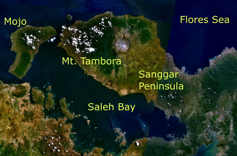
Mt. Tambora and its surroundings as seen from space
  
The 1815 eruption of Mount Tambora was one of the most powerful in recorded history and classified as a VEI-7 event. Mount Tambora is on the island of Sumbawa in Indonesia. The eruption that began on 10 April 1815 was preceded by between six months and three years of increased steaming and small phreatic eruptions. The eruption column lowered global temperatures, and some experts believe this led to global cooling and worldwide harvest failures, sometimes known as the Year Without a Summer.
  
Chronology of the eruption
Mount Tambora experienced several centuries of inactive dormancy before 1815, as the result of the gradual cooling of hydrous magma in a closed magma chamber. Inside the chamber at depths between 1.5–4.5 km (0.93–2.80 mi), the exsolution of a high-pressure fluid magma formed during cooling and crystallisation of the magma. Overpressure of the chamber of about 4.,000–5.000 bar was generated, and the temperature ranged from 700–850 °C. In 1812, the caldera began to rumble and generated a dark cloud.
On 5 April 1815, a moderate-sized eruption occurred, followed by thunderous detonation sounds, heard in Makassar on Sulawesi, 380 km away, Batavia (now Jakarta) on Java 1.260 km away, and Ternate on the Molucca Islands 1.400 km away. On the morning of 6 April, volcanic ash began to fall in East Java with faint detonation sounds lasting until 10 April. What was first thought to be sound of firing guns was heard on 10 April on Sumatra island more than 2,600 km away.
At about 7 p.m. on 10 April, the eruptions intensified. Three columns of flame rose up and merged. The whole mountain was turned into a flowing mass of "liquid fire". Pumice stones of up to 20 cm in diameter started to rain down at approximately 20.00, followed by ash at around 21.00 – 22.00. Pyroclastic flows cascaded down the mountain to the sea on all sides of the peninsula, wiping out the village of Tambora. Loud explosions were heard until the next evening, 11 April. The ash veil had spread as far as West Java and South Sulawesi. A "nitrous" odour was noticeable in Batavia and heavy tephra-tinged rain fell, finally receding between 11 and 17 April.
The explosion is estimated to have been VEI 7. It had roughly four times the energy of the 1883 Krakatoa eruption, meaning that it was equivalent to an 800 Mt explosion. An estimated 160 km3 of pyroclastic trachyandesite was ejected, weighing approximately 1.414 kg. This has left a caldera measuring 6–7 km across and 600–700 m deep. The density of fallen ash in Makassar was 636 kg/m². Before the explosion, Mount Tambora was approximately 4,300 m high, one of the tallest peaks in the Indonesian archipelago. After the explosion, it now measures only 2.851 m.
   

domingo, junho 15, 2014

O Pinatubo, vulcão das Flipinas, teve há 23 anos uma erupção que afetou o clima do mundo inteiro

The eruption column of Mount Pinatubo on June 12, 1991, three days before the climactic eruption

Mount Pinatubo is an active stratovolcano located on the island of Luzon, near the tripoint of the Philippine provinces of Zambales, Tarlac, and Pampanga. It is located in the Cabusilan Mountains separating the west coast of Luzon from the central plains. Before the volcanic activities of 1991, its eruptive history was unknown to most people. It was heavily eroded, inconspicuous and obscured from view. It was covered with dense forest which supported a population of several thousand indigenous people, the Aetas, who fled to the mountains during the Spanish conquest of the Philippines.
The volcano's Plinian/Ultra-Plinian eruption on June 15, 1991, produced the second largest terrestrial eruption of the 20th century after the 1912 eruption of Novarupta in the Alaska Peninsula. Complicating the eruption was the arrival of Typhoon Yunya bringing a lethal mix of ash and rain. Successful predictions at the onset of the climactic eruption led to the evacuation of tens of thousands of people from the surrounding areas, saving many lives, but the surrounding areas were severely damaged by pyroclastic flows, ash deposits, and subsequently, by the lahars caused by rainwaters re-mobilizing earlier volcanic deposits causing extensive destruction to infrastructure and altering the river systems months to years after the eruption.
The effects of the eruption were felt worldwide. It ejected roughly 10,000,000,000 tonnes (1.1×10¹⁰short tons) or 10 km3 of magma, and 20,000,000 tonnes (22,000,000 short tons) of SO
2, bringing vast quantities of minerals and metals to the surface environment. It injected large amounts of particulate into the stratosphere – more than any eruption since that of Krakatoa in 1883. Over the following months, the aerosols formed a global layer of sulfuric acid haze. Global temperatures dropped by about 0.5 °C and ozone depletion temporarily increased substantially.

quinta-feira, abril 10, 2014

Há 199 anos a maior explosão estudada por vulcanólogos aconteceu na Indonésia

Topographic map of Tambora and Sumbawa

Mount Tambora (or Tamboro) is an active stratovolcano on the island of Sumbawa, Indonesia. Sumbawa is flanked both to the north and south by oceanic crust, and Tambora was formed by the active subduction zone beneath it. This raised Mount Tambora as high as 4.300 m, making it, in the 18th century, one of the tallest peaks in the Indonesian archipelago. After a large magma chamber inside the mountain filled over the course of several decades, volcanic activity reached a historic climax in the eruption of 10 April 1815. This eruption was approximately VEI-7, the only eruption unambiguously confirmed of that size since the Lake Taupo eruption in about AD 180. The Heaven Lake eruption of Baekdu Mountain, circa AD 969, may have also been VEI-7.
With an estimated ejecta volume of 160 km3, Tambora's 1815 outburst was the largest volcanic eruption in recorded history. The explosion was heard on Sumatra island more than 2,000 km (1,200 mi) away. Heavy volcanic ash falls were observed as far away as Borneo, Sulawesi, Java and Maluku islands. Most deaths from the eruption were from starvation and disease, as the eruptive fallout ruined agricultural productivity in the local region. The death toll was at least 71.000 people, of whom 11.000–12.000 were killed directly by the eruption; the often-cited figure of 92.000 people killed is believed to be overestimated.
The eruption caused global climate anomalies that included the phenomenon known as "volcanic winter": 1816 became known as the "Year Without a Summer" because of the effect on North American and European weather. Crops failed and livestock died in much of the Northern Hemisphere, resulting in the worst famine of the 19th century.
During an excavation in 2004, a team of archaeologists discovered cultural remains buried by the 1815 eruption. They were kept intact beneath the 3 m deep pyroclastic deposits. At the site, dubbed the Pompeii of the East, the artifacts were preserved in the positions they had occupied in 1815.

Mt. Tambora and its surroundings as seen from space

The 1815 eruption of Mount Tambora was one of the most powerful in recorded history and classified as a VEI-7 event. Mount Tambora is on the island of Sumbawa in Indonesia. The eruption that began on 10 April 1815 was preceded by between six months and three years of increased steaming and small phreatic eruptions. The eruption column lowered global temperatures, and some experts believe this led to global cooling and worldwide harvest failures, sometimes known as the Year Without a Summer.
Chronology of the eruption
Mount Tambora experienced several centuries of inactive dormancy before 1815, as the result of the gradual cooling of hydrous magma in a closed magma chamber. Inside the chamber at depths between 1.5–4.5 km (0.93–2.80 mi), the exsolution of a high-pressure fluid magma formed during cooling and crystallisation of the magma. Overpressure of the chamber of about 4.,000–5.000 bar was generated, and the temperature ranged from 700–850 °C. In 1812, the caldera began to rumble and generated a dark cloud.
On 5 April 1815, a moderate-sized eruption occurred, followed by thunderous detonation sounds, heard in Makassar on Sulawesi, 380 km away, Batavia (now Jakarta) on Java 1.260 km away, and Ternate on the Molucca Islands 1.400 km away. On the morning of 6 April, volcanic ash began to fall in East Java with faint detonation sounds lasting until 10 April. What was first thought to be sound of firing guns was heard on 10 April on Sumatra island more than 2,600 km away.
At about 7 p.m. on 10 April, the eruptions intensified. Three columns of flame rose up and merged. The whole mountain was turned into a flowing mass of "liquid fire". Pumice stones of up to 20 cm in diameter started to rain down at approximately 20.00, followed by ash at around 21.00 – 22.00. Pyroclastic flows cascaded down the mountain to the sea on all sides of the peninsula, wiping out the village of Tambora. Loud explosions were heard until the next evening, 11 April. The ash veil had spread as far as West Java and South Sulawesi. A "nitrous" odour was noticeable in Batavia and heavy tephra-tinged rain fell, finally receding between 11 and 17 April.
The explosion is estimated to have been VEI 7. It had roughly four times the energy of the 1883 Krakatoa eruption, meaning that it was equivalent to an 800 Mt explosion. An estimated 160 km3 of pyroclastic trachyandesite was ejected, weighing approximately 1.414 kg. This has left a caldera measuring 6–7 km across and 600–700 m deep. The density of fallen ash in Makassar was 636 kg/m². Before the explosion, Mount Tambora was approximately 4,300 m high, one of the tallest peaks in the Indonesian archipelago. After the explosion, it now measures only 2.851 m.

sábado, maio 18, 2013

O Monte Santa Helena entrou em erupção há 33 anos

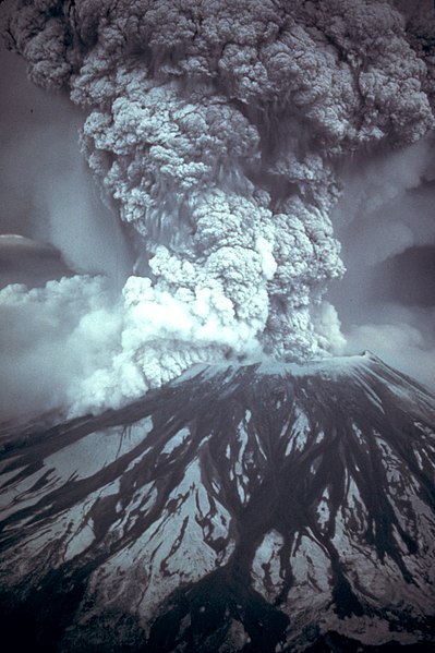
O Monte Santa Helena (em inglês Mount St. Helens) é um vulcão activo que fica no sudoeste do estado norte-americano de Washington, 160 quilómetros a sul de Seattle.
Após 127 anos de inatividade o vulcão entrou violentamente em erupção no dia 18 de maio de 1980, às 08.30 horas, matando 57 pessoas e ferindo muitas outras.
Após um tremor de terra de magnitude 5,1 na Escala de Richter, o lado norte do monte entrou em violenta erupção provocando danos ambientais numa área de 550 km². A cinza emanada da erupção provocou problemas respiratórios nos habitantes até 1550 quilómetros de distância do vulcão.
Como resultado da explosão a altura da cratera do vulcão diminuiu cerca de 400 metros, passando de 2950 para 2549 metros, e teve sua largura aumentada em cerca de dois quilómetros.

Map of eruption deposits

In 1980, a major volcanic eruption occurred at Mount St. Helens, a volcano located in Washington, in the United States. The eruption (which was a VEI 5 event) was the only significant one to occur in the contiguous 48 US states since the 1915 eruption of Lassen Peak in California. The eruption was preceded by a two-month series of earthquakes and steam-venting episodes, caused by an injection of magma at shallow depth below the volcano that created a huge bulge and a fracture system on Mount St. Helens' north slope.
Prior to the eruption, USGS scientists convinced local authorities to close Mount St. Helens to the general public and to maintain the closure in spite of pressure to re-open it; their work saved thousands of lives. An earthquake at 8:32:17 a.m. PDT (UTC−7) on Sunday, May 18, 1980, caused the entire weakened north face to slide away, suddenly exposing the partly molten, gas- and steam-rich rock in the volcano to lower pressure. The rock responded by exploding a hot mix of lava and pulverized older rock toward Spirit Lake so fast that it overtook the avalanching north face.
An eruption column rose 80,000 feet (24,400 m) into the atmosphere and deposited ash in 11 U.S. states. At the same time, snow, ice and several entire glaciers on the volcano melted, forming a series of large lahars (volcanic mudslides) that reached as far as the Columbia River, nearly 50 miles (80 km) to the southwest. Less severe outbursts continued into the next day only to be followed by other large but not as destructive eruptions later in 1980.
Fifty-seven people (including innkeeper Harry R. Truman, photographer Reid Blackburn and geologist David A. Johnston) perished. Hundreds of square miles were reduced to wasteland causing over a billion U.S. dollars in damage ($2.74 billion in 2011 dollars), thousands of game animals killed, and Mount St. Helens was left with a crater on its north side. At the time of the eruption, the summit of the volcano was owned by the Burlington Northern Railroad, but afterward the land passed to the United States Forest Service. The area was later preserved, as it was, in the Mount St. Helens National Volcanic Monument.