Mostrar mensagens com a etiqueta ano sem verão. Mostrar todas as mensagens

quarta-feira, abril 10, 2013

Há 198 anos ocorreu a maior erupção histórica na Terra

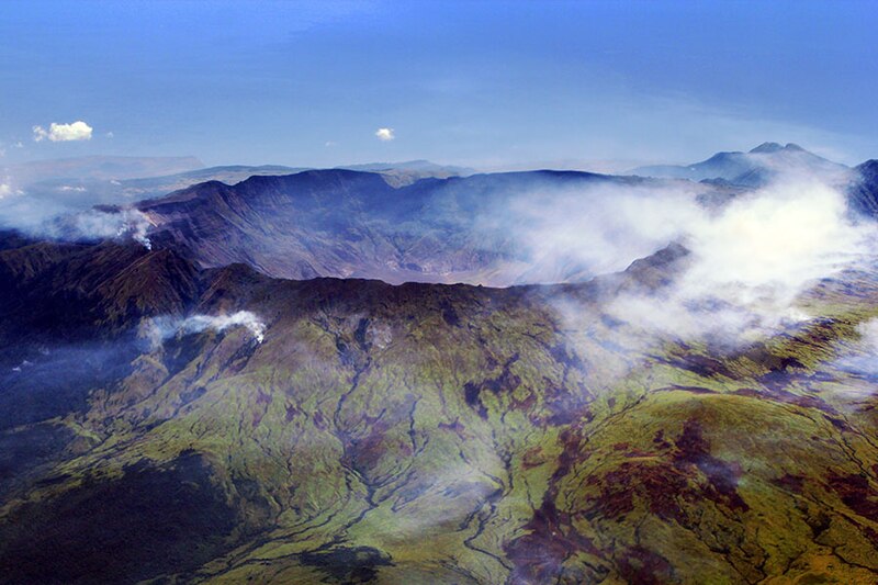
Vista aérea da caldeira do monte Tambora

O monte Tambora ou vulcão Tambora é um estratovulcão ou vulcão composto, ativo, na ilha de Sumbawa, Indonésia.
A ilha de Sumbawa é flanqueada tanto a norte como a sul por crosta oceânica e o Tambora foi formado pelas zonas de subducção ativas sob ele. Isto elevou o Monte Tambora a uma altura de 4300 m, fazendo-o uma das mais altas formações do arquipélago da Indonésia e injetando uma grande câmara magmática dentro da montanha. Demorando séculos para abastecer a sua câmara magmática, a sua atividade vulcânica atingindo o seu máximo em abril de 1815.
O monte Tambora entrou em erupção entre 5 e 10 de abril de 1815, atingindo o nível 7 no índice de explosividade vulcânica, realizando a maior erupção desde a erupção do lago Taupo, em 181 d.C. Esta erupção é considerada a maior registada na Terra, detendo o recorde do volume de matéria expelida: 180.000.000.000 m³ ou 180 km³.
A explosão foi ouvida na ilha de Samatra (a mais de 2000 km distante). Uma enorme queda de cinza vulcânica foi observada em locais distantes como nas ilhas de Bornéu, Celebes, Java e arquipélago das Molucas. A atividade começou três anos antes, de uma forma moderada, seguindo-se a enorme explosão que lançou material a uma altura de 33 km, que, no entanto, ainda não foi o ponto culminante da actividade. Cinco dias depois, houve material eruptivo lançado a 44 km de altura, escurecendo o céu num raio de 500 km durante três dias e matando cerca de 60.000 pessoas, havendo ainda estimativas de 71.000 mortos, das quais de 11 a 12 mil mortas diretamente pela erupção; a frequentemente citada estimativa de 92.000 mortos é considerada superestimada. A erupção criou anomalias climáticas globais, pois não houve verão no hemisfério norte, em consequência desta erupção, o que provocou a morte de milhares de pessoas devido a falta de alimentos, com registos estatísticos confiáveis especialmente na Europa, passando o ano de 1816 a ser conhecido no Hemisfério Norte como o ano sem Verão. Muitas culturas agrícolas colapsaram e o gado morreu, resultando na pior fome do século XIX. Durante uma escavação em 2004, uma equipa de arqueólogos descobriu artefatos da cultura que permaneceram enterrados pela erupção de 1815. Eles mantinham-se intactos, sob 3 metros de depósitos piroclásticos. Neste sítio arqueológico, apelidado "a Pompeia do Oriente", os artefatos foram preservados nas posições que ocupavam em 1815.
Depois da erupção, a montanha do vulcão ficou com metade da altura anterior e formou-se uma enorme caldeira, hoje contendo um lago.

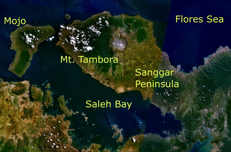
Imagem de satélite do Tambora

terça-feira, abril 10, 2012

A maior erupção histórica bem estudada ocorreu há 197 anos

Aerial view of the caldera of Mount Tambora

Mount Tambora (or Tamboro) is an active stratovolcano, also known as a composite volcano, on the island of Sumbawa, Indonesia. Sumbawa is flanked both to the north and south by oceanic crust, and Tambora was formed by the active subduction zone beneath it. This raised Mount Tambora as high as 4,300 m, making it formerly one of the tallest peaks in the Indonesian archipelago. After a large magma chamber inside the mountain filled over the course of several decades, volcanic activity reached a historic climax in the super-colossal eruption of April 1815. The 1815 eruption was approximately VEI 7, the only eruption of that size since the Lake Taupo eruption in about 180 CE.
With an estimated ejecta volume of 160 km3, Tambora's 1815 outburst was the largest volcanic eruption in recorded history. The explosion was heard on Sumatra island (more than 2,000 km away). Heavy volcanic ash falls were observed as far away as Borneo, Sulawesi, Java and Maluku islands. Most deaths from the eruption were from starvation and disease, as the eruptive fallout ruined agricultural productivity in the local region. The death toll was at least 71,000 people (the most deadly eruption in recorded history), of whom 11,000–12,000 were killed directly by the eruption; the often-cited figure of 92,000 people killed is believed to be overestimated.
The eruption created global climate anomalies that included the phenomenon known as "volcanic winter": 1816 became known as the "Year Without a Summer" because of the effect on North American and European weather. Agricultural crops failed and livestock died in much of the Northern Hemisphere, resulting in the worst famine of the 19th century. During an excavation in 2004, a team of archaeologists discovered cultural remains buried by the 1815 eruption. They were kept intact beneath the 3 m deep pyroclastic deposits. At the site, dubbed the Pompeii of the East, the artefacts were preserved in the positions they had occupied in 1815.

Mount Tambora is located on Sumbawa Island, part of the Lesser Sunda Islands. It is a segment of the Sunda Arc, a string of volcanic islands that forms the southern chain of the Indonesian archipelago. Tambora forms its own peninsula on Sumbawa, known as the Sanggar peninsula. At the north of the peninsula is the Flores Sea, and at the south is Saleh Bay, 86 km long and 36 km wide. At the mouth of Saleh Bay there is an islet called Moyo (Indonesian: Pulau Moyo)
Besides its interest for seismologists and volcanologists, who monitor the mountain's activity, Mount Tambora is an area of scientific studies for archaeologists and biologists. The mountain also attracts tourists for hiking and wildlife activities. The two nearest cities are Dompu and Bima. There are three concentrations of villages around the mountain slope. At the east is Sanggar village, to the northwest are Doro Peti and Pesanggrahan villages, and to the west is Calabai village.
There are two ascent routes to reach the caldera. The first route starts from Doro Mboha village southeast of the mountain. This route follows a paved road through a cashew plantation until it reaches 1,150 m above sea level. The end of this route is the southern part of the caldera at 1,950 m, reachable by a hiking track. This location is usually used as a base camp to monitor the volcanic activity, because it only takes one hour to reach the caldera. The second route starts from Pancasila village northwest of the mountain. Using the second route, the caldera is accessible only by foot.
In August 2011, the alert level for the volcano was raised from Level I to Level II after increasing activity was reported in the caldera, including earthquakes and smoke emissions. In September 2011 the alert level was raised to Level III after increasing activity.

Mt. Tambora and its surroundings as seen from space

Chronology of the eruption

Mount Tambora experienced several centuries of inactive dormancy before 1815, as the result of the gradual cooling of hydrous magma in a closed magma chamber. Inside the chamber at depths between 1,5 – 4,5 km, the exsolution of a high-pressure fluid magma formed during cooling and crystallisation of the magma. Overpressure of the chamber of about 4.000 – 5.000 bar was generated, and the temperature ranged from 700–850 °C.
In 1812, the caldera began to rumble and generated a dark cloud.
On 5 April 1815, a moderate-sized eruption occurred, followed by thunderous detonation sounds, heard in Makassar on Sulawesi, 380 km away, Batavia (now Jakarta) on Java 1,260 km away, and Ternate on the Molucca Islands 1,400 km away. On the morning of April 6, volcanic ash began to fall in East Java with faint detonation sounds lasting until 10 April. What was first thought to be sound of firing guns was heard on April 10 on Sumatra island (more than 2,600 km away).
At about 7 p.m. on 10 April, the eruptions intensified. Three columns of flame rose up and merged. The whole mountain was turned into a flowing mass of "liquid fire". Pumice stones of up to 20 cm in diameter started to rain down at approximately 8 p.m., followed by ash at around 9–10 p.m. Hot pyroclastic flows cascaded down the mountain to the sea on all sides of the peninsula, wiping out the village of Tambora. Loud explosions were heard until the next evening, 11 April. The ash veil had spread as far as West Java and South Sulawesi. A "nitrous" odour was noticeable in Batavia and heavy tephra-tinged rain fell, finally receding between 11 and 17 April.

The explosion is estimated to have been VEI 7. It had roughly four times the energy of the 1883 Krakatoa eruption, meaning that it was equivalent to an 800 megaton explosion. An estimated 160 km3 of pyroclastic trachyandesite was ejected, weighing approximately 1,414 kg. This has left a caldera measuring 6 – 7 km across and 600 – 700 m deep. The density of fallen ash in Makassar was 636 kg/m². Before the explosion, Mount Tambora was approximately 4,300 m high, one of the tallest peaks in the Indonesian archipelago. After the explosion, it now measures only 2,851 m.
The 1815 Tambora eruption is the largest observed eruption in recorded history.The explosion was heard 2,600 km away, and ash fell at least 1,300 km away. Pitch darkness was observed as far away as 600 km from the mountain summit for up to two days. Pyroclastic flows spread at least 20 km from the summit. Due to the eruption, Indonesia's Islands were attacked by tsunami waves reaching a height of up to 4 m.


 Aftermath

All vegetation on the island was destroyed. Uprooted trees, mixed with pumice ash, washed into the sea and formed rafts of up to 5 km across. One pumice raft was found in the Indian Ocean, near Calcutta on 1 and 3 October 1815. Clouds of thick ash still covered the summit on 23 April. Explosions ceased on 15 July, although smoke emissions were still observed as late as 23 August. Flames and rumbling aftershocks were reported in August 1819, four years after the event.
A moderate-sized tsunami struck the shores of various islands in the Indonesian archipelago on 10 April, with a height of up to 4 metres in Sanggar at around 10 p.m. A tsunami of 1 – 2 m in height was reported in Besuki, East Java, before midnight, and one of 2 metres in height in the Molucca Islands. The total death-toll has been estimated at around 4,600.
The eruption column reached the stratosphere, an altitude of more than 43 km. The coarser ash particles fell 1 to 2 weeks after the eruptions, but the finer ash particles stayed in the atmosphere from a few months up to a few years at an altitude of 10 – 30 km. Longitudinal winds spread these fine particles around the globe, creating optical phenomena. Prolonged and brilliantly colored sunsets and twilights were frequently seen in London, England between 28 June and 2 July 1815 and 3 September and 7 October 1815. The glow of the twilight sky typically appeared orange or red near the horizon and purple or pink above.
The estimated number of deaths varies depending on the source. Zollinger (1855) puts the number of direct deaths at 10,000, probably caused by pyroclastic flows. On Sumbawa island, there were 38,000 deaths due to starvation, and another 10,000 deaths occurred due to disease and hunger on Lombok island. Petroeschevsky (1949) estimated about 48,000 and 44,000 people were killed on Sumbawa and Lombok, respectively. Several authors use Petroeschevsky's figures, such as Stothers (1984), who cites 88,000 deaths in total. However, Tanguy et al. (1998) claimed Petroeschevsky's figures to be unfounded and based on untraceable references. Tanguy revised the number solely based on two credible sources, q.e., Zollinger, who himself spent several months on Sumbawa after the eruption, and Raffles's notes. Tanguy pointed out that there may have been additional victims on Bali and East Java because of famine and disease. Their estimate was 11,000 deaths from direct volcanic effects and 49,000 by post-eruption famine and epidemic diseases. Oppenheimer (2003) stated a modified number of at least 71,000 deaths in total.