Mostrar mensagens com a etiqueta Nova Orleães. Mostrar todas as mensagens

quinta-feira, agosto 29, 2024

O Furacão Katrina atingiu Nova Orleães há dezanove anos...

   
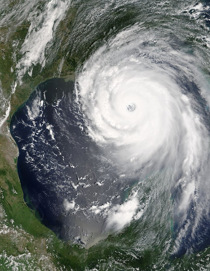
O Furacão Katrina foi uma tempestade tropical que alcançou a categoria 5 da escala de furacões de Saffir-Simpson (regredindo a 4 antes de chegar à costa sudeste dos Estados Unidos). Os ventos do furacão alcançaram mais de 280 quilómetros por hora e causaram grandes prejuízos na região litoral do sul dos Estados Unidos, especialmente em torno da região metropolitana de Nova Orleães, a 29 de agosto de 2005, de onde mais de um milhão de pessoas foram evacuadas. O furacão passou pelo sul da Flórida, causando em torno de dois mil milhões de dólares de prejuízo e causando seis mortes diretas. Foi a 11ª tempestade de 2005 a receber nome, sendo o quarto entre os furacões.
O Furacão Katrina causou aproximadamente mil e oitocentas mortes, sendo um dos furacões mais destrutivos a ter atingido os Estados Unidos. O furacão paralisou muito da extração de petróleo e gás natural dos Estados Unidos, uma vez que boa parte do petróleo americano é extraído no Golfo do México.
   
Impacto
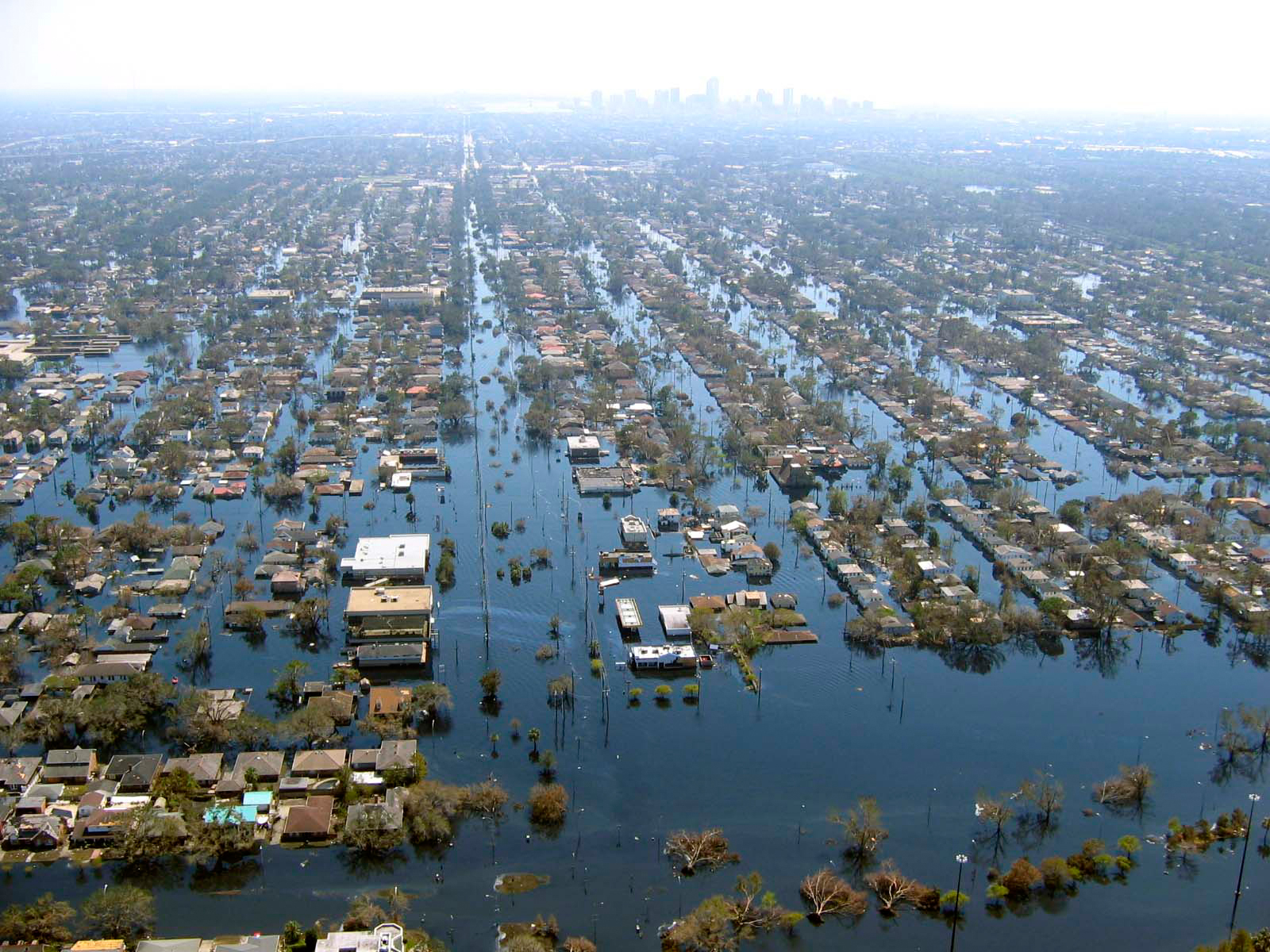
Em 29 de agosto, a maré ciclónica do Katrina causou 53 diferentes pontos de passagem de água nos diques da Grande Nova Orleães, submergindo oitenta por cento da cidade. Um relatório de junho de 2007 feito pela Sociedade Americana de Engenheiros Civis indicou que dois terços das inundações foram causadas pelas múltiplas falhas nas barreiras da cidade, mas não foram mencionadas as comportas que não foram fechadas. A tempestade também devastou as costas do Mississippi e do Alabama, tornando o Katrina o mais destrutivo e mais caro desastre natural na história dos Estados Unidos, e o mais mortal furacão desde o Okeechobee, em 1928. O dano total do Katrina é estimado em 81,2 mil milhões dólares americanos (em valores de 2005), quase o dobro do custo da tempestade até então mais cara, o furacão Andrew, quando ajustado pela inflação.
O número de mortos confirmados (total de mortes diretas e indiretas) é 1.836, principalmente nos estados da Luisiana (1577) e Mississipi (238), e ficaram 624 feridos. No entanto, 135 pessoas continuam classificadas como desaparecidas na Luisiana, e muitas das mortes são indiretas, mas é quase impossível determinar a causa exata de algumas das mortes. A relativa falta de status, poder e recursos colocaram muitas mulheres em risco de serem vítimas de violência sexual durante o furacão Katrina.
Os dados oficiais sobre o desastre fizeram que a área cobriu, nos Estados Unidos, de cerca de 233.000 quilómetros quadrados, uma área quase tão grande quanto o Reino Unido. O furacão deixou cerca de três milhões de pessoas sem eletricidade. Em 3 de setembro de 2005, Michael Chertoff, secretário da Homeland Security, descreveu, no rescaldo do furacão Katrina, que seria "provavelmente a pior catástrofe, ou conjunto de catástrofes", na história do país, referindo-se ao furacão em si e à inundação de Nova Orleães.
   
Imagem de radar da trajetória do Katrina à passagem pela Luisiana
   
Flooding in Venice, Louisiana
   
Katrina caused severe destruction along the Gulf coast from central Florida to Texas, much of it due to the storm surge. The most significant number of deaths occurred in New Orleans, Louisiana, which flooded as its levee system failed, in many cases hours after the storm had moved inland. Eventually 80% of the city and large tracts of neighboring parishes became flooded, and the floodwaters lingered for weeks. However, the worst property damage occurred in coastal areas, such as Mississippi beachfront towns; over 90 percent of these were flooded. Boats and casino barges rammed buildings, pushing cars and houses inland; water reached 6–12 miles (10–19 km) from the beach.
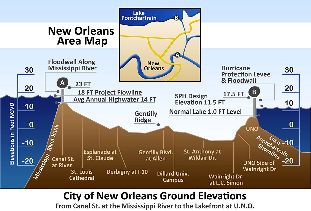
The hurricane surge protection failures in New Orleans are considered the worst civil engineering disaster in U.S. history, and prompted a lawsuit against the U.S. Army Corps of Engineers (USACE), the designers and builders of the levee system as mandated by the Flood Control Act of 1965. Responsibility for the failures and flooding was laid squarely on the Army Corps in January 2008 by Judge Stanwood Duval, U.S. District Court, but the federal agency could not be held financially liable because of sovereign immunity in the Flood Control Act of 1928. There was also an investigation of the responses from federal, state and local governments, resulting in the resignation of Federal Emergency Management Agency (FEMA) director Michael D. Brown, and of New Orleans Police Department (NOPD) Superintendent Eddie Compass. Many other government officials were criticized for their responses, especially New Orleans Mayor Ray Nagin, Louisiana Governor Kathleen Blanco, and President George W. Bush.
Several agencies including the United States Coast Guard (USCG), National Hurricane Center (NHC), and National Weather Service (NWS) were commended for their actions. They provided accurate hurricane weather tracking forecasts with sufficient lead time.
  
Vertical cross-section of New Orleans, showing maximum levee height of 23 feet (7 m) - vertical scale exaggerated
        
in Wikipédia

terça-feira, abril 30, 2024

Os Estados Unidos adquiriram o território da Louisiana há 221 anos

The modern United States, with Louisiana Purchase overlay (in green)
        
The Louisiana Purchase (French: Vente de la Louisiane - "Sale of Louisiana") was the acquisition by the United States of America in 1803 of 828,000 square miles (2,140,000 km2) of France's claim to the territory of Louisiana. The U.S. paid 50 million francs ($11,250,000) plus cancellation of debts worth 18 million francs ($3,750,000), for a total sum of 15 million dollars (less than 3 cents per acre) for the Louisiana territory ($230 million in 2012 dollars, less than 42 cents per acre).
The Louisiana territory encompassed all or part of 15 present U.S. states and two Canadian provinces. The land purchased contained all of present-day Arkansas, Missouri, Iowa, Oklahoma, Kansas, and Nebraska; parts of Minnesota that were west of the Mississippi River; most of North Dakota; most of South Dakota; northeastern New Mexico; northern Texas; the portions of Montana, Wyoming, and Colorado east of the Continental Divide; Louisiana west of the Mississippi River, including the city of New Orleans; and small portions of land that would eventually become part of the Canadian provinces of Alberta and Saskatchewan.
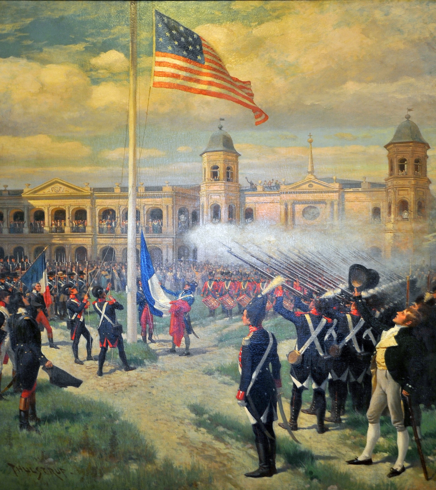
France controlled this vast area from 1699 until 1762, the year it gave the territory to its ally Spain. Under Napoleon Bonaparte, France took back the territory in 1800 in the hope of building an empire in North America. A slave revolt in Haiti and an impending war with Britain, however, led France to abandon these plans and sell the entire territory to the United States, who had originally intended only to seek the purchase of New Orleans and its adjacent lands.
The purchase of the territory of Louisiana took place during the presidency of Thomas Jefferson. At the time, the purchase faced domestic opposition because it was thought to be unconstitutional. Although he agreed that the U.S. Constitution did not contain provisions for acquiring territory, Jefferson decided to go ahead with the purchase anyway in order to remove France's presence in the region and to protect both U.S. trade access to the port of New Orleans and free passage on the Mississippi River.
   
(...)
   
Although the foreign minister Talleyrand opposed the plan, on April 10, 1803, Napoleon told the Treasury Minister François de Barbé-Marbois that he was considering selling the entire Louisiana Territory to the United States. On April 11, 1803, just days before Monroe's arrival, Barbé-Marbois offered Livingston all of Louisiana for $15 million, equivalent to about $230 million in present-day values.
The American representatives were prepared to pay up to $10 million for New Orleans and its environs, but were dumbfounded when the vastly larger territory was offered for $15 million. Jefferson had authorized Livingston only to purchase New Orleans. However, Livingston was certain that the United States would accept the offer.
The Americans thought that Napoleon might withdraw the offer at any time, preventing the United States from acquiring New Orleans, so they agreed and signed the Louisiana Purchase Treaty on April 30, 1803. On July 4, 1803, the treaty reached Washington, D.C.. The Louisiana Territory was vast, stretching from the Gulf of Mexico in the south to Rupert's Land in the north, and from the Mississippi River in the east to the Rocky Mountains in the west. Acquiring the territory would double the size of the United States at a sum of less than 3 cents per acre.
    

quarta-feira, fevereiro 07, 2024

Earl King nasceu há noventa anos...

     
Earl King (New Orleans, February 7, 1934 – New Orleans, April 17, 2003) was an American singer, guitarist, and songwriter, most active in blues music. A composer of well known standards such as "Come On" (covered by Jimi Hendrix and Stevie Ray Vaughan) and Professor Longhair's "Big Chief", he is an important figure in New Orleans R&B music.
   
Biography
King was born Earl Silas Johnson IV in New Orleans, Louisiana. His father, a local piano player, died when King was still a baby, and he was brought up by his mother. With his mother, he started going to church at an early age. In his youth he sang gospel music, but took the advice of a friend to switch to blues to make a better living.
King started to play guitar at age 15. Soon he started entering talent contests at local clubs including the Dew Drop Inn. It was at one of those clubs where he met his idol Guitar Slim. King started imitating Slim, and his presence gave a big impact on his musical directions. In 1954, when Slim was injured in an automobile accident (right around the time Slim had the #1 R&B hit with "The Things That I Used To Do"), King was deputized to continue Slim's band tour, representing himself as Slim. After succeeding in this role, King became a regular at the Dew Drop Inn.
His first recording came in 1953. He released a 78 "Have you Gone Crazy" b/w "Begging At Your Mercy" on Savoy label as Earl Johnson. The following year, talent scout Johnny Vincent introduced King to Specialty label, and he recorded some sides including "Mother's Love" which created a little stir locally. In 1955, King signed with Johnny Vincent's label, Ace. His first single from the label "Those Lonely, Lonely Nights" become hit reaching #7 on the US Billboard R&B chart. He continued to record during his five year stay at the label, and during that time, he also he started writing songs for other artists such as Roland Stone and Jimmy Clanton.
In 1960, Dave Bartholomew invited King to record for the Imperial Records. At the label, he was backed by host of musicians including Bob and George French, James Booker, and Wardell Quezergue. It was at this label he recorded his signature songs "Come On" and "Trick Bag". The former of which remained a much covered standard for decades especially for Jimi Hendrix, Stevie Ray Vaughan and Anson Funderburgh. The latter has also been widely covered including versions by The Meters and Robert Palmer.
King also co-wrote a number of songs with Bartholomew, either under his own name or under the pseudonyms of "Pearl King" and "E.C. King". One of the best known collaborations between Bartholomew and King is the rhythm and blues standard, "I Hear You Knocking", originally recorded in 1955. The latter song is variously credited to Pearl King and E.C King as the co-writer, with Bartholomew.
King recorded for Imperial till 1963, but he went without a recording contract for the remainder of the 1960s. During this time, he mostly concentrated in producing and songwriting for local labels NOLA and Watch. His compositions from this era includes Professor Longhair's "Big Chief", Willie Tee's "Teasin' You", and Lee Dorsey's "Do-Re-Mi". He also went to Detroit for an audition with Motown Records and recorded a few tracks in the mid 1960s. Three tracks from the session appeared on the Motown's Blue Evolution CD released in 1996.
In 1972, he was joined by Allen Toussaint and the Meters to record the album Street Parade. Though Atlantic initially showed interest in releasing it, they eventually declined. The title cut "Street Parade" was released as a single from Kansu label at the time, but the rest had to wait till 1982 to see the light of the day, when the album was finally released by Charly Records in the UK.
During the 1970s, he recorded another album That Good Old New Orleans Rock 'n Roll which was released by Sonet in 1977. He also appeared on the New Orleans Jazz & Heritage Festival 1976 album.
In the early 1980s, he also met Hammond Scott, co-owner of Black Top Records, and started to record for the label. The first album Glazed, backed up by Roomful of Blues was released in 1986, and a second album, Sexual Telepathy came in 1990. It featured Snooks Eaglin as a guest on two tracks, and also Ronnie Earl & The Broadcasters backed him up on some tracks. His third from the label Hard River To Cross (1993) was backed by George Porter, Jr., David Torkanowsky, and Herman V. Ernest, III.
In 2001, he was hospitalized for an illness during a tour to New Zealand, however, that did not stop him from performing. In December of the same year, he toured Japan, and he continued to perform off and on locally in New Orleans until his death.
He died on April 17, 2003, from diabetes related complications, just a week before the New Orleans Jazz & Heritage Festival. His funeral was held during the Festival period on April 30, and many musicians including Dr. John, Leo Nocentelli and Aaron Neville were in attendance. His Imperial recordings, which have been long out-of-print, were reissued on CD soon after he died. The June 2003 issue of a local music magazine OffBeat paid a tribute to King by doing a series of special articles on him.


terça-feira, agosto 29, 2023

O Furacão Katrina assolou Nova Orleães há dezoito anos...

   
O Furacão Katrina foi uma tempestade tropical que alcançou a categoria 5 da escala de furacões de Saffir-Simpson (regredindo a 4 antes de chegar à costa sudeste dos Estados Unidos). Os ventos do furacão alcançaram mais de 280 quilómetros por hora e causaram grandes prejuízos na região litoral do sul dos Estados Unidos, especialmente em torno da região metropolitana de Nova Orleães, a 29 de agosto de 2005, onde mais de um milhão de pessoas foram evacuadas. O furacão passou pelo sul da Flórida, causando em torno de dois mil milhões de dólares de prejuízo e causando seis mortes diretas. Foi a 11ª tempestade de 2005 a receber nome, sendo o quarto entre os furacões.
O Furacão Katrina causou aproximadamente mil e oitocentas mortes, sendo um dos furacões mais destrutivos a ter atingido os Estados Unidos. O furacão paralisou muito da extração de petróleo e gás natural dos Estados Unidos, uma vez que boa parte do petróleo americano é extraído no Golfo do México.
   
Impacto
Em 29 de agosto, a maré ciclónica do Katrina causou 53 diferentes pontos de passagem de água nos diques da Grande Nova Orleães, submergindo oitenta por cento da cidade. Um relatório de junho de 2007 feito pela Sociedade Americana de Engenheiros Civis indicou que dois terços das inundações foram causadas pelas múltiplas falhas nas barreiras da cidade, mas não foram mencionadas as comportas que não foram fechadas. A tempestade também devastou as costas do Mississippi e do Alabama, tornando o Katrina o mais destrutivo e mais caro desastre natural na história dos Estados Unidos, e o mais mortal furacão desde o Okeechobee, em 1928. O dano total do Katrina é estimado em 81,2 mil milhões dólares americanos (em valores de 2005), quase o dobro do custo da tempestade até então mais cara, o furacão Andrew, quando ajustado pela inflação.
O número de mortos confirmados (total de mortes diretas e indiretas) é 1.836, principalmente nos estados da Luisiana (1577) e Mississipi (238), e ficaram 624 feridos. No entanto, 135 pessoas continuam classificadas como desaparecidas na Luisiana, e muitas das mortes são indiretas, mas é quase impossível determinar a causa exata de algumas das mortes. A relativa falta de status, poder e recursos colocaram muitas mulheres em risco de serem vítimas de violência sexual durante o furacão Katrina.
Os dados oficiais sobre o desastre fizeram que a área cobriu, nos Estados Unidos, de cerca de 233.000 quilómetros quadrados, uma área quase tão grande quanto o Reino Unido. O furacão deixou cerca de três milhões de pessoas sem eletricidade. Em 3 de setembro de 2005, Michael Chertoff, secretário da Homeland Security, descreveu, no rescaldo do furacão Katrina, que seria "provavelmente a pior catástrofe, ou conjunto de catástrofes", na história do país, referindo-se ao furacão em si e à inundação de Nova Orleães.
   
Imagem de radar da trajetória do Katrina à passagem pela Luisiana
   
Flooding in Venice, Louisiana
   
Katrina caused severe destruction along the Gulf coast from central Florida to Texas, much of it due to the storm surge. The most significant number of deaths occurred in New Orleans, Louisiana, which flooded as its levee system failed, in many cases hours after the storm had moved inland. Eventually 80% of the city and large tracts of neighboring parishes became flooded, and the floodwaters lingered for weeks. However, the worst property damage occurred in coastal areas, such as Mississippi beachfront towns; over 90 percent of these were flooded. Boats and casino barges rammed buildings, pushing cars and houses inland; water reached 6–12 miles (10–19 km) from the beach.
The hurricane surge protection failures in New Orleans are considered the worst civil engineering disaster in U.S. history, and prompted a lawsuit against the U.S. Army Corps of Engineers (USACE), the designers and builders of the levee system as mandated by the Flood Control Act of 1965. Responsibility for the failures and flooding was laid squarely on the Army Corps in January 2008 by Judge Stanwood Duval, U.S. District Court, but the federal agency could not be held financially liable because of sovereign immunity in the Flood Control Act of 1928. There was also an investigation of the responses from federal, state and local governments, resulting in the resignation of Federal Emergency Management Agency (FEMA) director Michael D. Brown, and of New Orleans Police Department (NOPD) Superintendent Eddie Compass. Many other government officials were criticized for their responses, especially New Orleans Mayor Ray Nagin, Louisiana Governor Kathleen Blanco, and President George W. Bush.
Several agencies including the United States Coast Guard (USCG), National Hurricane Center (NHC), and National Weather Service (NWS) were commended for their actions. They provided accurate hurricane weather tracking forecasts with sufficient lead time.
  
Vertical cross-section of New Orleans, showing maximum levee height of 23 feet (7 m) - vertical scale exaggerated
        
in Wikipédia

domingo, abril 30, 2023

A França vendeu o território da Louisiana há duzentos e vinte anos

The modern United States, with Louisiana Purchase overlay (in green)
        
The Louisiana Purchase (French: Vente de la Louisiane "Sale of Louisiana") was the acquisition by the United States of America in 1803 of 828,000 square miles (2,140,000 km2) of France's claim to the territory of Louisiana. The U.S. paid 50 million francs ($11,250,000) plus cancellation of debts worth 18 million francs ($3,750,000), for a total sum of 15 million dollars (less than 3 cents per acre) for the Louisiana territory ($230 million in 2012 dollars, less than 42 cents per acre).
The Louisiana territory encompassed all or part of 15 present U.S. states and two Canadian provinces. The land purchased contained all of present-day Arkansas, Missouri, Iowa, Oklahoma, Kansas, and Nebraska; parts of Minnesota that were west of the Mississippi River; most of North Dakota; most of South Dakota; northeastern New Mexico; northern Texas; the portions of Montana, Wyoming, and Colorado east of the Continental Divide; Louisiana west of the Mississippi River, including the city of New Orleans; and small portions of land that would eventually become part of the Canadian provinces of Alberta and Saskatchewan.
France controlled this vast area from 1699 until 1762, the year it gave the territory to its ally Spain. Under Napoleon Bonaparte, France took back the territory in 1800 in the hope of building an empire in North America. A slave revolt in Haiti and an impending war with Britain, however, led France to abandon these plans and sell the entire territory to the United States, who had originally intended only to seek the purchase of New Orleans and its adjacent lands.
The purchase of the territory of Louisiana took place during the presidency of Thomas Jefferson. At the time, the purchase faced domestic opposition because it was thought to be unconstitutional. Although he agreed that the U.S. Constitution did not contain provisions for acquiring territory, Jefferson decided to go ahead with the purchase anyway in order to remove France's presence in the region and to protect both U.S. trade access to the port of New Orleans and free passage on the Mississippi River.
   
(...)
   
Although the foreign minister Talleyrand opposed the plan, on April 10, 1803, Napoleon told the Treasury Minister François de Barbé-Marbois that he was considering selling the entire Louisiana Territory to the United States. On April 11, 1803, just days before Monroe's arrival, Barbé-Marbois offered Livingston all of Louisiana for $15 million, equivalent to about $230 million in present-day values.
The American representatives were prepared to pay up to $10 million for New Orleans and its environs, but were dumbfounded when the vastly larger territory was offered for $15 million. Jefferson had authorized Livingston only to purchase New Orleans. However, Livingston was certain that the United States would accept the offer.
The Americans thought that Napoleon might withdraw the offer at any time, preventing the United States from acquiring New Orleans, so they agreed and signed the Louisiana Purchase Treaty on April 30, 1803. On July 4, 1803, the treaty reached Washington, D.C.. The Louisiana Territory was vast, stretching from the Gulf of Mexico in the south to Rupert's Land in the north, and from the Mississippi River in the east to the Rocky Mountains in the west. Acquiring the territory would double the size of the United States at a sum of less than 3 cents per acre.
    

segunda-feira, agosto 29, 2022

O Furacão Katrina assolou Nova Orleães há dezassete anos...

   
O Furacão Katrina foi uma tempestade tropical que alcançou a categoria 5 da escala de furacões de Saffir-Simpson (regredindo a 4 antes de chegar à costa sudeste dos Estados Unidos). Os ventos do furacão alcançaram mais de 280 quilómetros por hora e causaram grandes prejuízos na região litoral do sul dos Estados Unidos, especialmente em torno da região metropolitana de Nova Orleães, a 29 de agosto de 2005, onde mais de um milhão de pessoas foram evacuadas. O furacão passou pelo sul da Flórida, causando em torno de dois mil milhões de dólares de prejuízo e causando seis mortes diretas. Foi a 11ª tempestade de 2005 a receber nome, sendo o quarto entre os furacões.
O Furacão Katrina causou aproximadamente mil e oitocentas mortes, sendo um dos furacões mais destrutivos a ter atingido os Estados Unidos. O furacão paralisou muito da extração de petróleo e gás natural dos Estados Unidos, uma vez que boa parte do petróleo americano é extraído no Golfo do México.
   
Impacto
Em 29 de agosto, a maré ciclónica do Katrina causou 53 diferentes pontos de passagem de água nos diques da Grande Nova Orleães, submergindo oitenta por cento da cidade. Um relatório de junho de 2007 feito pela Sociedade Americana de Engenheiros Civis indicou que dois terços das inundações foram causadas pelas múltiplas falhas nas barreiras da cidade, mas não foram mencionadas as comportas que não foram fechadas. A tempestade também devastou as costas do Mississippi e do Alabama, tornando o Katrina o mais destrutivo e mais caro desastre natural na história dos Estados Unidos, e o mais mortal furacão desde o Okeechobee, em 1928. O dano total do Katrina é estimado em 81,2 mil milhões dólares americanos (em valores de 2005), quase o dobro do custo da tempestade até então mais cara, o furacão Andrew, quando ajustado pela inflação.
O número de mortos confirmados (total de mortes diretas e indiretas) é 1.836, principalmente nos estados da Luisiana (1577) e Mississipi (238), e ficaram 624 feridos. No entanto, 135 pessoas continuam classificadas como desaparecidas na Luisiana, e muitas das mortes são indiretas, mas é quase impossível determinar a causa exata de algumas das mortes. A relativa falta de status, poder e recursos colocaram muitas mulheres em risco de serem vítimas de violência sexual durante o furacão Katrina.
Os dados oficiais sobre o desastre fizeram que a área cobriu, nos Estados Unidos, de cerca de 233.000 quilómetros quadrados, uma área quase tão grande quanto o Reino Unido. O furacão deixou cerca de três milhões de pessoas sem eletricidade. Em 3 de setembro de 2005, Michael Chertoff, secretário da Homeland Security, descreveu, no rescaldo do furacão Katrina, que seria "provavelmente a pior catástrofe, ou conjunto de catástrofes", na história do país, referindo-se ao furacão em si e à inundação de Nova Orleães.
   
Imagem de radar da trajectória do Katrina à passagem pela Luisiana
   
Flooding in Venice, Louisiana
   
Katrina caused severe destruction along the Gulf coast from central Florida to Texas, much of it due to the storm surge. The most significant number of deaths occurred in New Orleans, Louisiana, which flooded as its levee system failed, in many cases hours after the storm had moved inland. Eventually 80% of the city and large tracts of neighboring parishes became flooded, and the floodwaters lingered for weeks. However, the worst property damage occurred in coastal areas, such as Mississippi beachfront towns; over 90 percent of these were flooded. Boats and casino barges rammed buildings, pushing cars and houses inland; water reached 6–12 miles (10–19 km) from the beach.
The hurricane surge protection failures in New Orleans are considered the worst civil engineering disaster in U.S. history, and prompted a lawsuit against the U.S. Army Corps of Engineers (USACE), the designers and builders of the levee system as mandated by the Flood Control Act of 1965. Responsibility for the failures and flooding was laid squarely on the Army Corps in January 2008 by Judge Stanwood Duval, U.S. District Court, but the federal agency could not be held financially liable because of sovereign immunity in the Flood Control Act of 1928. There was also an investigation of the responses from federal, state and local governments, resulting in the resignation of Federal Emergency Management Agency (FEMA) director Michael D. Brown, and of New Orleans Police Department (NOPD) Superintendent Eddie Compass. Many other government officials were criticized for their responses, especially New Orleans Mayor Ray Nagin, Louisiana Governor Kathleen Blanco, and President George W. Bush.
Several agencies including the United States Coast Guard (USCG), National Hurricane Center (NHC), and National Weather Service (NWS) were commended for their actions. They provided accurate hurricane weather tracking forecasts with sufficient lead time.
  
Vertical cross-section of New Orleans, showing maximum levee height of 23 feet (7 m) - vertical scale exaggerated
        
in Wikipédia

sábado, abril 30, 2022

Os Estados Unidos da América compraram o território da Louisiana há 219 anos

The modern United States, with Louisiana Purchase overlay (in green)
    
The Louisiana Purchase (French: Vente de la Louisiane "Sale of Louisiana") was the acquisition by the United States of America in 1803 of 828,000 square miles (2,140,000 km2) of France's claim to the territory of Louisiana. The U.S. paid 50 million francs ($11,250,000) plus cancellation of debts worth 18 million francs ($3,750,000), for a total sum of 15 million dollars (less than 3 cents per acre) for the Louisiana territory ($230 million in 2012 dollars, less than 42 cents per acre).
The Louisiana territory encompassed all or part of 15 present U.S. states and two Canadian provinces. The land purchased contained all of present-day Arkansas, Missouri, Iowa, Oklahoma, Kansas, and Nebraska; parts of Minnesota that were west of the Mississippi River; most of North Dakota; most of South Dakota; northeastern New Mexico; northern Texas; the portions of Montana, Wyoming, and Colorado east of the Continental Divide; Louisiana west of the Mississippi River, including the city of New Orleans; and small portions of land that would eventually become part of the Canadian provinces of Alberta and Saskatchewan.
France controlled this vast area from 1699 until 1762, the year it gave the territory to its ally Spain. Under Napoleon Bonaparte, France took back the territory in 1800 in the hope of building an empire in North America. A slave revolt in Haiti and an impending war with Britain, however, led France to abandon these plans and sell the entire territory to the United States, who had originally intended only to seek the purchase of New Orleans and its adjacent lands.
The purchase of the territory of Louisiana took place during the presidency of Thomas Jefferson. At the time, the purchase faced domestic opposition because it was thought to be unconstitutional. Although he agreed that the U.S. Constitution did not contain provisions for acquiring territory, Jefferson decided to go ahead with the purchase anyway in order to remove France's presence in the region and to protect both U.S. trade access to the port of New Orleans and free passage on the Mississippi River.
   
(...)
   
Although the foreign minister Talleyrand opposed the plan, on April 10, 1803, Napoleon told the Treasury Minister François de Barbé-Marbois that he was considering selling the entire Louisiana Territory to the United States. On April 11, 1803, just days before Monroe's arrival, Barbé-Marbois offered Livingston all of Louisiana for $15 million, equivalent to about $230 million in present-day values.
The American representatives were prepared to pay up to $10 million for New Orleans and its environs, but were dumbfounded when the vastly larger territory was offered for $15 million. Jefferson had authorized Livingston only to purchase New Orleans. However, Livingston was certain that the United States would accept the offer.
The Americans thought that Napoleon might withdraw the offer at any time, preventing the United States from acquiring New Orleans, so they agreed and signed the Louisiana Purchase Treaty on April 30, 1803. On July 4, 1803, the treaty reached Washington, D.C.. The Louisiana Territory was vast, stretching from the Gulf of Mexico in the south to Rupert's Land in the north, and from the Mississippi River in the east to the Rocky Mountains in the west. Acquiring the territory would double the size of the United States at a sum of less than 3 cents per acre.
    

domingo, agosto 29, 2021

O Furacão Katrina destruiu Nova Orleães há dezasseis anos

   
O Furacão Katrina foi uma tempestade tropical que alcançou a categoria 5 da escala de furacões de Saffir-Simpson (regredindo a 4 antes de chegar à costa sudeste dos Estados Unidos). Os ventos do furacão alcançaram mais de 280 quilómetros por hora e causaram grandes prejuízos na região litoral do sul dos Estados Unidos, especialmente em torno da região metropolitana de Nova Orleães, a 29 de agosto de 2005, onde mais de um milhão de pessoas foram evacuadas. O furacão passou pelo sul da Flórida, causando em torno de dois mil milhões de dólares de prejuízo e causando seis mortes diretas. Foi a 11ª tempestade de 2005 a receber nome, sendo o quarto entre os furacões.
O Furacão Katrina causou aproximadamente mil e oitocentas mortes, sendo um dos furacões mais destrutivos a ter atingido os Estados Unidos. O furacão paralisou muito da extração de petróleo e gás natural dos Estados Unidos, uma vez que boa parte do petróleo americano é extraído no Golfo do México.
   
Impacto
Em 29 de agosto, a maré ciclónica do Katrina causou 53 diferentes pontos de passagem de água nos diques da Grande Nova Orleães, submergindo oitenta por cento da cidade. Um relatório de junho de 2007 feito pela Sociedade Americana de Engenheiros Civis indicou que dois terços das inundações foram causadas pelas múltiplas falhas nas barreiras da cidade, mas não foram mencionadas as comportas que não foram fechadas. A tempestade também devastou as costas do Mississippi e do Alabama, tornando o Katrina o mais destrutivo e mais caro desastre natural na história dos Estados Unidos, e o mais mortal furacão desde o Okeechobee, em 1928. O dano total do Katrina é estimado em 81,2 mil milhões dólares americanos (em valores de 2005), quase o dobro do custo da tempestade até então mais cara, o furacão Andrew, quando ajustado pela inflação.
O número de mortos confirmados (total de mortes diretas e indiretas) é 1836, principalmente da Luisiana (1577) e Mississipi (238), e ficaram 624 feridos. No entanto, 135 pessoas continuam classificadas como desaparecidas na Luisiana, e muitas das mortes são indiretas, mas é quase impossível determinar a causa exata de algumas das mortes. A relativa falta de status, poder e recursos colocaram muitas mulheres em risco de serem vítimas de violência sexual durante o furacão Katrina.
Os dados oficiais sobre o desastre fizeram que a área cobriu, nos Estados Unidos, de cerca de 233.000 quilómetros quadrados, uma área quase tão grande quanto o Reino Unido. O furacão deixou cerca de três milhões de pessoas sem eletricidade. Em 3 de setembro de 2005, Michael Chertoff, secretário da Homeland Security, descreveu, no rescaldo do furacão Katrina, que seria "provavelmente a pior catástrofe, ou conjunto de catástrofes", na história do país, referindo-se ao furacão em si e à inundação de Nova Orleães.
   
Imagem de radar da trajectória do Katrina à passagem pela Luisiana
   
Flooding in Venice, Louisiana
   
Katrina caused severe destruction along the Gulf coast from central Florida to Texas, much of it due to the storm surge. The most significant number of deaths occurred in New Orleans, Louisiana, which flooded as its levee system failed, in many cases hours after the storm had moved inland. Eventually 80% of the city and large tracts of neighboring parishes became flooded, and the floodwaters lingered for weeks. However, the worst property damage occurred in coastal areas, such as Mississippi beachfront towns; over 90 percent of these were flooded. Boats and casino barges rammed buildings, pushing cars and houses inland; water reached 6–12 miles (10–19 km) from the beach.
The hurricane surge protection failures in New Orleans are considered the worst civil engineering disaster in U.S. history, and prompted a lawsuit against the U.S. Army Corps of Engineers (USACE), the designers and builders of the levee system as mandated by the Flood Control Act of 1965. Responsibility for the failures and flooding was laid squarely on the Army Corps in January 2008 by Judge Stanwood Duval, U.S. District Court, but the federal agency could not be held financially liable because of sovereign immunity in the Flood Control Act of 1928. There was also an investigation of the responses from federal, state and local governments, resulting in the resignation of Federal Emergency Management Agency (FEMA) director Michael D. Brown, and of New Orleans Police Department (NOPD) Superintendent Eddie Compass. Many other government officials were criticized for their responses, especially New Orleans Mayor Ray Nagin, Louisiana Governor Kathleen Blanco, and President George W. Bush.
Several agencies including the United States Coast Guard (USCG), National Hurricane Center (NHC), and National Weather Service (NWS) were commended for their actions. They provided accurate hurricane weather tracking forecasts with sufficient lead time.
  
Vertical cross-section of New Orleans, showing maximum levee height of 23 feet (7 m) - vertical scale exaggerated
      
in Wikipédia

sexta-feira, abril 30, 2021

Os Estados Unidos da América compraram o território da Louisiana há 218 anos

The modern United States, with Louisiana Purchase overlay (in green)
    
The Louisiana Purchase (French: Vente de la Louisiane "Sale of Louisiana") was the acquisition by the United States of America in 1803 of 828,000 square miles (2,140,000 km2) of France's claim to the territory of Louisiana. The U.S. paid 50 million francs ($11,250,000) plus cancellation of debts worth 18 million francs ($3,750,000), for a total sum of 15 million dollars (less than 3 cents per acre) for the Louisiana territory ($230 million in 2012 dollars, less than 42 cents per acre).
The Louisiana territory encompassed all or part of 15 present U.S. states and two Canadian provinces. The land purchased contained all of present-day Arkansas, Missouri, Iowa, Oklahoma, Kansas, and Nebraska; parts of Minnesota that were west of the Mississippi River; most of North Dakota; most of South Dakota; northeastern New Mexico; northern Texas; the portions of Montana, Wyoming, and Colorado east of the Continental Divide; Louisiana west of the Mississippi River, including the city of New Orleans; and small portions of land that would eventually become part of the Canadian provinces of Alberta and Saskatchewan.
France controlled this vast area from 1699 until 1762, the year it gave the territory to its ally Spain. Under Napoleon Bonaparte, France took back the territory in 1800 in the hope of building an empire in North America. A slave revolt in Haiti and an impending war with Britain, however, led France to abandon these plans and sell the entire territory to the United States, who had originally intended only to seek the purchase of New Orleans and its adjacent lands.
The purchase of the territory of Louisiana took place during the presidency of Thomas Jefferson. At the time, the purchase faced domestic opposition because it was thought to be unconstitutional. Although he agreed that the U.S. Constitution did not contain provisions for acquiring territory, Jefferson decided to go ahead with the purchase anyway in order to remove France's presence in the region and to protect both U.S. trade access to the port of New Orleans and free passage on the Mississippi River.
   
(...)
   
Although the foreign minister Talleyrand opposed the plan, on April 10, 1803, Napoleon told the Treasury Minister François de Barbé-Marbois that he was considering selling the entire Louisiana Territory to the United States. On April 11, 1803, just days before Monroe's arrival, Barbé-Marbois offered Livingston all of Louisiana for $15 million, equivalent to about $230 million in present-day values.
The American representatives were prepared to pay up to $10 million for New Orleans and its environs, but were dumbfounded when the vastly larger territory was offered for $15 million. Jefferson had authorized Livingston only to purchase New Orleans. However, Livingston was certain that the United States would accept the offer.
The Americans thought that Napoleon might withdraw the offer at any time, preventing the United States from acquiring New Orleans, so they agreed and signed the Louisiana Purchase Treaty on April 30, 1803. On July 4, 1803, the treaty reached Washington, D.C.. The Louisiana Territory was vast, stretching from the Gulf of Mexico in the south to Rupert's Land in the north, and from the Mississippi River in the east to the Rocky Mountains in the west. Acquiring the territory would double the size of the United States at a sum of less than 3 cents per acre.
    

sábado, agosto 29, 2020

O Furacão Katrina foi há quinze anos

   
O Furacão Katrina foi uma tempestade tropical que alcançou a categoria 5 da escala de furacões de Saffir-Simpson (regredindo a 4 antes de chegar à costa sudeste dos Estados Unidos). Os ventos do furacão alcançaram mais de 280 quilómetros por hora e causaram grandes prejuízos na região litoral do sul dos Estados Unidos, especialmente em torno da região metropolitana de Nova Orleães, a 29 de agosto de 2005, onde mais de um milhão de pessoas foram evacuadas. O furacão passou pelo sul da Flórida, causando em torno de dois mil milhões de dólares de prejuízo e causando seis mortes diretas. Foi a 11ª tempestade de 2005 a receber nome, sendo o quarto entre os furacões.
O Furacão Katrina causou aproximadamente mil e oitocentas mortes, sendo um dos furacões mais destrutivos a ter atingido os Estados Unidos. O furacão paralisou muito da extração de petróleo e gás natural dos Estados Unidos, uma vez que boa parte do petróleo americano é extraído no Golfo do México.
   
Impacto
Em 29 de agosto, a maré ciclónica do Katrina causou 53 diferentes pontos de passagem de água nos diques da Grande Nova Orleães, submergindo oitenta por cento da cidade. Um relatório de junho de 2007 feito pela Sociedade Americana de Engenheiros Civis indicou que dois terços das inundações foram causadas pelas múltiplas falhas nas barreiras da cidade, mas não foram mencionadas as comportas que não foram fechadas. A tempestade também devastou as costas do Mississippi e do Alabama, tornando o Katrina o mais destrutivo e mais caro desastre natural na história dos Estados Unidos, e o mais mortal furacão desde o Okeechobee, em 1928. O dano total do Katrina é estimado em 81,2 mil milhões dólares americanos (em valores de 2005), quase o dobro do custo da tempestade até então mais cara, o furacão Andrew, quando ajustado pela inflação.
O número de mortos confirmados (total de mortes diretas e indiretas) é 1836, principalmente da Luisiana (1577) e Mississipi (238), e ficaram 624 feridos. No entanto, 135 pessoas continuam classificadas como desaparecidas na Luisiana, e muitas das mortes são indiretas, mas é quase impossível determinar a causa exata de algumas das mortes. A relativa falta de status, poder e recursos colocaram muitas mulheres em risco de serem vítimas de violência sexual durante o furacão Katrina.
Os dados oficiais sobre o desastre fizeram que a área cobriu, nos Estados Unidos, de cerca de 233.000 quilómetros quadrados, uma área quase tão grande quanto o Reino Unido. O furacão deixou cerca de três milhões de pessoas sem eletricidade. Em 3 de setembro de 2005, Michael Chertoff, secretário da Homeland Security, descreveu, no rescaldo do furacão Katrina, que seria "provavelmente a pior catástrofe, ou conjunto de catástrofes", na história do país, referindo-se ao furacão em si e à inundação de Nova Orleães.
   
Imagem de radar da trajectória do Katrina à passagem pela Luisiana
   
Flooding in Venice, Louisiana
   
Katrina caused severe destruction along the Gulf coast from central Florida to Texas, much of it due to the storm surge. The most significant number of deaths occurred in New Orleans, Louisiana, which flooded as its levee system failed, in many cases hours after the storm had moved inland. Eventually 80% of the city and large tracts of neighboring parishes became flooded, and the floodwaters lingered for weeks. However, the worst property damage occurred in coastal areas, such as Mississippi beachfront towns; over 90 percent of these were flooded. Boats and casino barges rammed buildings, pushing cars and houses inland; water reached 6–12 miles (10–19 km) from the beach.
The hurricane surge protection failures in New Orleans are considered the worst civil engineering disaster in U.S. history, and prompted a lawsuit against the U.S. Army Corps of Engineers (USACE), the designers and builders of the levee system as mandated by the Flood Control Act of 1965. Responsibility for the failures and flooding was laid squarely on the Army Corps in January 2008 by Judge Stanwood Duval, U.S. District Court, but the federal agency could not be held financially liable because of sovereign immunity in the Flood Control Act of 1928. There was also an investigation of the responses from federal, state and local governments, resulting in the resignation of Federal Emergency Management Agency (FEMA) director Michael D. Brown, and of New Orleans Police Department (NOPD) Superintendent Eddie Compass. Many other government officials were criticized for their responses, especially New Orleans Mayor Ray Nagin, Louisiana Governor Kathleen Blanco, and President George W. Bush.
Several agencies including the United States Coast Guard (USCG), National Hurricane Center (NHC), and National Weather Service (NWS) were commended for their actions. They provided accurate hurricane weather tracking forecasts with sufficient lead time.
  
Vertical cross-section of New Orleans, showing maximum levee height of 23 feet (7 m) - vertical scale exaggerated
    
in Wikipédia