Mostrar mensagens com a etiqueta Caraíbas. Mostrar todas as mensagens

domingo, outubro 25, 2026

A Invasão de Granada foi há 43 anos

https://upload.wikimedia.org/wikipedia/commons/1/14/US_Army_Rangers_parachute_into_Grenada_during_Operation_Urgent_Fury.jpg?utm_source=pt.wikipedia.org&utm_campaign=imageinfo&utm_content=thumbnail_unscaled
Rangers do Exército dos Estados Unidos saltam de paraquedas em Granada durante a Operação Fúria Urgente


Data25 de outubro – 2 de novembro de 1983 (8 dias)
LocalGranada
DesfechoVitória dos Estados Unidos e de seus aliados
Beligerantes

 Estados Unidos
Granada Oposição Granadina

Aliados:
 Antígua e Barbuda
 Barbados
Dominica
 Jamaica
Santa Lúcia
São Vicente e Granadinas
Organização dos Estados Americanos

Granada Governo Revolucionário de Granada
 Cuba

Conselheiros militares:
 União Soviética
 Alemanha Oriental
Coreia do Norte
Líbia Líbia

Comandantes

Estados Unidos Ronald Reagan
Estados Unidos Vice-almirante Joseph Metcalf III
Estados Unidos Major-general Norman Schwarzkopf
Granada Nicholas Brathwaite

Granada Hudson Austin  Rendição (militar)
Cuba Pedro Tórtolo  Rendição (militar)

Forças

Estados Unidos 7 300 soldados
OEA: 353 combatentes

Granada ~1 500 soldados
Cuba 722 soldados

Baixas

Estados Unidos 19 mortos e 116 feridos

Granada 45 mortos e 358 feridos
Cuba 24 mortos (dos quais dois eram militares profissionais), 59 feridos e 638 capturados

24–67 civis mortos (18 dos quais no bombardeio acidental de um hospital psiquiátrico pela Força Aérea dos Estados Unidos)

A Invasão de Granada (nome de código: Operação Fúria Urgente) foi uma invasão da nação insular de Granada por forças militares dos Estados Unidos e outros países, em resposta a um golpe de estado liderado pelo vice-primeiro-ministro Bernard Coard, que depôs o então primeiro-ministro granadino, Maurice Bishop, posteriormente executado.
Em 25 de outubro de 1983, os Estados Unidos, Barbados, Jamaica e membros da Organização de Estados das Caraíbas Orientais desembarcaram navios em Granada, derrotaram a resistência granadina e derrubaram o governo de Coard. O dia 25 de outubro é um dia de festa nacional em Granada, chamada Dia de Ação de Graças, para comemorar este acontecimento.
 
https://thumb.wikimedia.org/wikipedia/commons/thumb/f/f5/CH-53D_HMM-261_Grenada_Okt1983.jpeg/960px-CH-53D_HMM-261_Grenada_Okt1983.jpeg?utm_source=pt.wikipedia.org&utm_campaign=imageinfo&utm_content=thumbnail 

Um helicóptero americano CH-53D pousando ao lado de uma metralhadora ZU-23-2 abandonada pelos granadinos


in Wikipédia

domingo, junho 07, 2026

Um terramoto arrasou a antiga capital da Jamaica há 334 anos

Old map of Port Royal
  
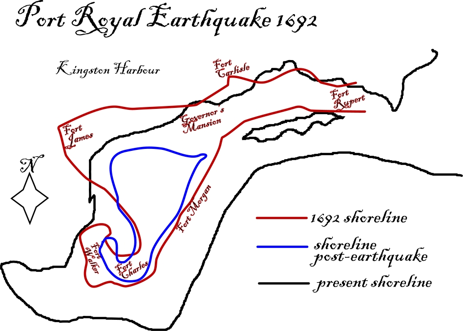
The 1692 Jamaica earthquake struck Port Royal, Jamaica on June 7. A stopped pocket watch found in the harbor in 1969 indicated that it occurred around 11:43 a.m. Port Royal was, at the time, the unofficial capital of Jamaica, and one of the busiest and wealthiest ports in the West Indies. It was known both as the "storehouse and treasury of the West Indies" and "one of the wickedest places on earth", being a common home port for the many privateers and pirates operating within the Caribbean Sea. The earthquake caused most of the city to sink below sea level and about 2,000 people died as a result of the earthquake and the following tsunami. About 3,000 people died in the days following the earthquakes due to injuries and disease.
   
Map of Port Royal showing shorelines before and after the earthquake
      
The island of Jamaica lies on the boundary between the Caribbean Plate and the Gonâve Microplate. The Gonâve microplate is a 1,100 km (680 mi) long strip of mainly oceanic crust formed by the Cayman spreading ridge within a strike-slip pull-apart basin on the northern transform margin of the Caribbean Plate with the North American Plate. Jamaica was formed by uplift associated with a restraining bend along this strike-slip structure. The focal mechanisms of earthquakes around Jamaica are primarily sinistral strike-slip along WSW-ENE trending faults and minor reverse or thrust motion on NW-SE trending faults. The 1692 event is thought to have occurred on one of these strike-slip faults.
  
The Gonâve microplate, showing the main fault zones that bound it
    
in Wikipédia

sábado, junho 07, 2025

Um sismo arrasou a antiga capital da Jamaica há 333 anos

Old map of Port Royal
  
The 1692 Jamaica earthquake struck Port Royal, Jamaica on June 7. A stopped pocket watch found in the harbor in 1969 indicated that it occurred around 11:43 a.m. Port Royal was, at the time, the unofficial capital of Jamaica, and one of the busiest and wealthiest ports in the West Indies. It was known both as the "storehouse and treasury of the West Indies" and "one of the wickedest places on earth", being a common home port for the many privateers and pirates operating within the Caribbean Sea. The earthquake caused most of the city to sink below sea level and about 2,000 people died as a result of the earthquake and the following tsunami. About 3,000 people died in the days following the earthquakes due to injuries and disease.
   
Map of Port Royal showing shorelines before and after the earthquake
      
The island of Jamaica lies on the boundary between the Caribbean Plate and the Gonâve Microplate. The Gonâve microplate is a 1,100 km (680 mi) long strip of mainly oceanic crust formed by the Cayman spreading ridge within a strike-slip pull-apart basin on the northern transform margin of the Caribbean Plate with the North American Plate. Jamaica was formed by uplift associated with a restraining bend along this strike-slip structure. The focal mechanisms of earthquakes around Jamaica are primarily sinistral strike-slip along WSW-ENE trending faults and minor reverse or thrust motion on NW-SE trending faults. The 1692 event is thought to have occurred on one of these strike-slip faults.
  
The Gonâve microplate, showing the main fault zones that bound it
    
in Wikipédia

sexta-feira, junho 07, 2024

Um sismo arrasou a antiga capital da Jamaica há 332 anos

Old map of Port Royal
  
The 1692 Jamaica earthquake struck Port Royal, Jamaica on June 7. A stopped pocket watch found in the harbor in 1969 indicated that it occurred around 11:43 a.m. Port Royal was, at the time, the unofficial capital of Jamaica, and one of the busiest and wealthiest ports in the West Indies. It was known both as the "storehouse and treasury of the West Indies" and "one of the wickedest places on earth", being a common home port for the many privateers and pirates operating within the Caribbean Sea. The earthquake caused most of the city to sink below sea level and about 2,000 people died as a result of the earthquake and the following tsunami. About 3,000 people died in the days following the earthquakes due to injuries and disease.
   
Map of Port Royal showing shorelines before and after the earthquake
      
The island of Jamaica lies on the boundary between the Caribbean Plate and the Gonâve Microplate. The Gonâve microplate is a 1,100 km (680 mi) long strip of mainly oceanic crust formed by the Cayman spreading ridge within a strike-slip pull-apart basin on the northern transform margin of the Caribbean Plate with the North American Plate. Jamaica was formed by uplift associated with a restraining bend along this strike-slip structure. The focal mechanisms of earthquakes around Jamaica are primarily sinistral strike-slip along WSW-ENE trending faults and minor reverse or thrust motion on NW-SE trending faults. The 1692 event is thought to have occurred on one of these strike-slip faults.
  
The Gonâve microplate, showing the main fault zones that bound it
    
in Wikipédia

quarta-feira, junho 07, 2023

Um terramoto destruiu a antiga capital da Jamaica há 331 anos

Old map of Port Royal
  
The 1692 Jamaica earthquake struck Port Royal, Jamaica on June 7. A stopped pocket watch found in the harbor in 1969 indicated that it occurred around 11:43 a.m. Port Royal was, at the time, the unofficial capital of Jamaica, and one of the busiest and wealthiest ports in the West Indies. It was known both as the "storehouse and treasury of the West Indies" and "one of the wickedest places on earth", being a common home port for the many privateers and pirates operating within the Caribbean Sea. The earthquake caused most of the city to sink below sea level and about 2,000 people died as a result of the earthquake and the following tsunami. About 3,000 people died in the days following the earthquakes due to injuries and disease.
   
Map of Port Royal showing shorelines before and after the earthquake
      
The island of Jamaica lies on the boundary between the Caribbean Plate and the Gonâve Microplate. The Gonâve microplate is a 1,100 km (680 mi) long strip of mainly oceanic crust formed by the Cayman spreading ridge within a strike-slip pull-apart basin on the northern transform margin of the Caribbean Plate with the North American Plate. Jamaica was formed by uplift associated with a restraining bend along this strike-slip structure. The focal mechanisms of earthquakes around Jamaica are primarily sinistral strike-slip along WSW-ENE trending faults and minor reverse or thrust motion on NW-SE trending faults. The 1692 event is thought to have occurred on one of these strike-slip faults.
  
The Gonâve microplate, showing the main fault zones that bound it
    
in Wikipédia

terça-feira, junho 07, 2022

A antiga capital da Jamaica foi arrasada por um sismo há 330 anos

Old map of Port Royal
  
The 1692 Jamaica earthquake struck Port Royal, Jamaica on June 7. A stopped pocket watch found in the harbor in 1969 indicated that it occurred around 11:43 a.m. Port Royal was, at the time, the unofficial capital of Jamaica, and one of the busiest and wealthiest ports in the West Indies. It was known both as the "storehouse and treasury of the West Indies" and "one of the wickedest places on earth", being a common home port for the many privateers and pirates operating within the Caribbean Sea. The earthquake caused most of the city to sink below sea level and about 2,000 people died as a result of the earthquake and the following tsunami. About 3,000 people died in the days following the earthquakes due to injuries and disease.
   
Map of Port Royal showing shorelines before and after the earthquake
      
The island of Jamaica lies on the boundary between the Caribbean Plate and the Gonâve Microplate. The Gonâve microplate is a 1,100 km (680 mi) long strip of mainly oceanic crust formed by the Cayman spreading ridge within a strike-slip pull-apart basin on the northern transform margin of the Caribbean Plate with the North American Plate. Jamaica was formed by uplift associated with a restraining bend along this strike-slip structure. The focal mechanisms of earthquakes around Jamaica are primarily sinistral strike-slip along WSW-ENE trending faults and minor reverse or thrust motion on NW-SE trending faults. The 1692 event is thought to have occurred on one of these strike-slip faults.
  
The Gonâve microplate, showing the main fault zones that bound it
    
in Wikipédia

segunda-feira, junho 07, 2021

Um sismo arrasou e fez desaparecer a antiga capital da Jamaica há 329 anos

Old map of Port Royal
  
The 1692 Jamaica earthquake struck Port Royal, Jamaica on June 7. A stopped pocket watch found in the harbor in 1969 indicated that it occurred around 11:43 a.m. Port Royal was, at the time, the unofficial capital of Jamaica, and one of the busiest and wealthiest ports in the West Indies. It was known both as the "storehouse and treasury of the West Indies" and "one of the wickedest places on earth", being a common home port for the many privateers and pirates operating within the Caribbean Sea. The earthquake caused most of the city to sink below sea level and about 2,000 people died as a result of the earthquake and the following tsunami. About 3,000 people died in the days following the earthquakes due to injuries and disease.
Map of Port Royal showing shorelines before and after the earthquake
  
The island of Jamaica lies on the boundary between the Caribbean Plate and the Gonâve Microplate. The Gonâve microplate is a 1,100 km (680 mi) long strip of mainly oceanic crust formed by the Cayman spreading ridge within a strike-slip pull-apart basin on the northern transform margin of the Caribbean Plate with the North American Plate. Jamaica was formed by uplift associated with a restraining bend along this strike-slip structure. The focal mechanisms of earthquakes around Jamaica are primarily sinistral strike-slip along WSW-ENE trending faults and minor reverse or thrust motion on NW-SE trending faults. The 1692 event is thought to have occurred on one of these strike-slip faults.
  
The Gonâve microplate, showing the main fault zones that bound it
    
in Wikipédia