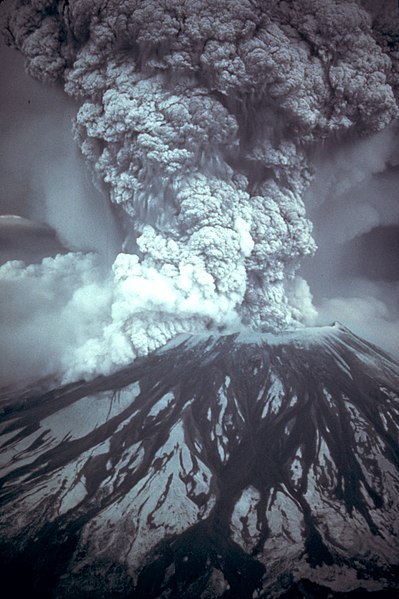
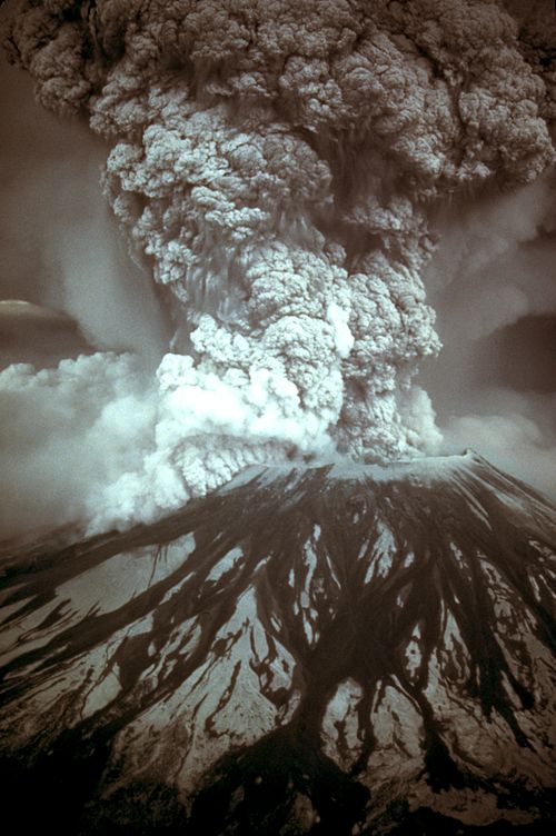
David Alexander Johnston (Chicago, December 18, 1949 – Mount St. Helens, May 18, 1980) was an American United States Geological Survey (USGS) volcanologist who was killed by the 1980 eruption of Mount St. Helens in the U.S. state of Washington. A principal scientist on the USGS monitoring team, Johnston was killed in the eruption while manning an observation post six miles (10 km) away on the morning of May 18, 1980. He was the first to report the eruption, transmitting "Vancouver! Vancouver! This is it!" before he was swept away by a lateral blast; despite a thorough search, Johnston's body was never found, but state highway workers discovered remnants of his USGS trailer in 1993.
Johnston's career took him across the United States, where he studied the Augustine Volcano in Alaska, the San Juan volcanic field in Colorado, and long-extinct volcanoes in Michigan. Johnston was a meticulous and talented scientist, known for his analyses of volcanic gases and their relationship to eruptions. This, along with his enthusiasm and positive attitude, made him liked and respected by many co-workers. After his death, other scientists lauded his character, both verbally and in dedications and letters. Johnston felt scientists must do what is necessary, including taking risks, to help protect the public from natural disasters. His work, and that of fellow USGS scientists, convinced authorities to close Mount St. Helens to the public before the 1980 eruption. They maintained the closure despite heavy pressure to re-open the area; their work saved thousands of lives. His story became intertwined with the popular image of volcanic eruptions and their threat to society, and a part of volcanology's history. To date, Johnston, along with his mentee Harry Glicken, is one of two American volcanologists known to have died in a volcanic eruption.

in Wikipédia


.jpg)