Irrupção silenciosa de magma elevou ilha açoriana 6,35 cm e parou de súbito sob a superfície

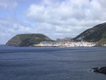
Morro Grande, na ilha de São Jorge, nos Açores
Uma série de sismos na ilha de São Jorge, nos Açores, revelou magma acumulado a apenas 1,6 quilómetros de profundidade. Segundo um novo estudo, falhas subterrâneas impediram a erupção. Tratou-se de uma quase-erupção, que nunca chegou a concretizar-se.
Em março de 2022, a pequena ilha açoriana de São Jorge foi subitamente atingida por uma série de sismos, após quase 60 anos sem atividade sísmica significativa.
Os tremores prolongaram-se durante meses, com micro-sismos a persistirem ao longo de dois anos, mas o que se estava a passar nas profundezas do subsolo da ilha açoriana continuava a ser um mistério.
Num novo estudo, uma equipa internacional de investigadores acredita ter clarificado a cadeia de eventos que na altura teve lugar.
O estudo, publicado na quinta-feira na revista Nature Communications, descreve como o magma irrompeu em direção à superfície em apenas dois dias, num volume equivalente a aproximadamente 32.000 piscinas olímpicas.
Ao analisarem dados sísmicos recolhidos em terra e no fundo do mar, juntamente com imagens de satélite, os investigadores concluíram que o magma subiu a partir de mais de 19 km de profundidade, acabando por estancar a cerca de 1,6 km abaixo da superfície.
Resumindo, tratou-se de uma quase-erupção que nunca chegou a concretizar-se, dizem os autores do estudo.
“Esta foi uma intrusão furtiva”, afirmou Stephen Hicks, investigador da University College London e autor principal do estudo, num comunicado publicado no EurekAlert.
“O magma deslocou-se rapidamente através da crosta, mas grande parte do seu percurso foi silenciosa, o que dificultou a previsão sobre se ocorreria ou não uma erupção”, acrescenta o investigador.
Acumulação subterrânea de magma fez a ilha crescer
Quando o magma empurra para cima através das camadas da crosta terrestre, frequentemente provoca erupções vulcânicas. Mas nem sempre. Por vezes, estanca a diversas profundidades, sem conseguir romper a superfície, explica a Discover Magazine.
Foi exatamente o que aconteceu sob São Jorge. Os Açores situam-se ao longo do Rift da Terceira, onde as placas tectónicas euroasiática e africana se afastam lentamente uma da outra, tornando a atividade sísmica relativamente comum.
A própria ilha, com apenas cerca de 56 km de comprimento e e cerca de 6,4 km de largura, tem um historial de sismos poderosos, incluindo um evento de magnitude 7,5 em 1757, um dos maiores sismos registados nos Açores.
Após o início dos sismos de 2022, os investigadores reconstituíram a atividade subterrânea recorrendo a uma combinação de registos sísmicos, medições por GPS e dados de satélite
Estes instrumentos revelaram que o solo se tinha elevado cerca de 6,35 cm - uma evidência forte de que o magma tinha penetrado na crosta superficial. Em escalas temporais longas, este tipo de soerguimento é, na verdade, uma das formas como as ilhas ganham altitude.
Os autores do estudo descobriram ainda que o magma se deslocou ao longo de um importante sistema de falhas que atravessa a ilha, conhecido como a Zona de Falha do Pico do Carvão.
As falhas podem guiar o magma e reduzir a pressão
As falhas e fraturas na crosta terrestre podem funcionar como vias de passagem para o magma ascendente, embora os cientistas continuem a trabalhar para compreender plenamente esta relação. No caso de São Jorge, o sistema de falhas parece ter desempenhado um papel surpreendentemente complexo.
Estudos anteriores já tinham demonstrado que esta zona de falha era capaz de produzir grandes sismos no passado. Durante a crise sísmica de 2022, em vez de um grande sismo, os investigadores observaram numerosos sismos de menor magnitude, agrupados ao longo da falha, desencadeados pelo movimento do magma em profundidade.
Segundo os investigadores, a falha funcionou como uma espécie de guia, facilitando a irrupção do magma. Ao mesmo tempo, poderá ter permitido que gases e fluidos escapassem lateralmente, reduzindo a pressão no interior do magma e impedindo, em última instância, a erupção.
“A falha funcionou simultaneamente como uma autoestrada e como uma fuga“, explica Pablo González, investigador do Conselho Superior de Investigações Científicas de Espanha e o coautor do estudo, no comunicado. “Ajudou o magma a subir, mas pode também ter impedido uma erupção”.
Compreender como o magma se desloca abaixo da superfície é fundamental para interpretar a agitação vulcânica e prever o que poderá acontecer a seguir.
Os Açores são um raro laboratório natural, onde sistemas magmáticos ativos se cruzam com grandes falhas geradoras de sismos, o que facilita o estudo, por parte dos cientistas, da interação em tempo real entre estruturas tectónicas e rocha fundida.
As observações dos eventos de São Jorge sugerem que irrupções maciças de magma podem desenvolver-se rapidamente e sem aviso prévio, mas revelam também de que forma as falhas geológicas influenciam se esse magma atinge a superfície ou fica retido em profundidade.
Ambas as conclusões são cruciais para tornar a atividade vulcânica mais previsível.
“Este estudo apoiou as autoridades locais na avaliação de uma potencial ameaça vulcânica”, explica Ricardo Ramalho, investigador da Universidade de Cardiff e também coautor do estudo, no comunicado.
“O estudo evidencia o valor de combinar dados geofísicos em terra e no mar para uma deteção e localização precisas de eventos sísmicos e de deformação do solo”, conclui o investigador português.
in ZAP


.jpg)


.jpg)